
Makian, known to local people as Mount Kie Besi, is a volcanic island, one of the Maluku Islands within the province of North Maluku in Indonesia. It lies near the southern end of a chain of volcanic islands off the western coast of the province's major island, Halmahera, and lies between the islands of Moti and Tidore to the north and Kayoa and the Bacan Group to the south. The island, which forms two districts within South Halmahera Regency of North Maluku Province, covers an area of 84.36 sq.km, and had a population of 12,394 at the 2010 Census, which rose to 14,000 at the 2020 Census.

The Barat Daya Islands are a group of islands in the Maluku province of Indonesia. The Indonesian phrase barat daya means 'south-west'.

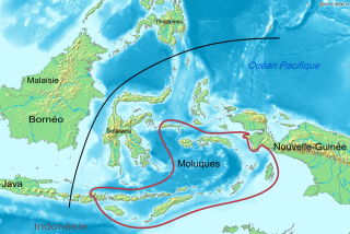
Maluku is a province of Indonesia. It comprises the central and southern regions of the Maluku Islands. The main city and capital of Maluku province is Ambon on the small Ambon Island. The land area is 46,150.92 km2, and the total population of this province at the 2010 census was 1,533,506 people, rising to 1,848,923 at the 2020 census. The official estimate as at mid 2022 was 1,881,727. Maluku is located in Eastern Indonesia. It is directly adjacent to North Maluku, Southwest Papua, and West Papua in the north, Central Sulawesi, and Southeast Sulawesi in the west, Banda Sea, East Timor and East Nusa Tenggara in the south and Arafura Sea, Central Papua and South Papua in the east.

UTC+09:00 is an identifier for a time offset from UTC of +09:00.

Kisar, also known as Yotowawa, is a small island in the Southwestern Moluccas in Indonesia, located to the northeast of Timor Island. Most of the island is included within the Southernmost Islands District within the Southwest Islands Regency of Maluku Province. The District previously also includes the larger Romang Island further north, but this with its own outliers was subsequently split off to form its own district. The rest of the island forms the North Kisar District within the regency. It is one of the 92 officially listed outlying islands of Indonesia. The principal town is Wonreli, with 6,652 inhabitants at the 2010 Census.
Liran is a small island off the southwest coast of Wetar Island, Indonesia. Administratively it is part of West Wetar District within the Southwest Maluku Regency. The East Timorese island Atauro is 12 km to the southwest. Liran is the westernmost of the Barat Daya Islands in the province of Maluku. It covers an area of 39.14 km2 and had 841 inhabitants in 2019.

The Letti Islands of Indonesia are part of the Maluku Islands, in southwest Maluku Province. They are also called the "Lemola" Archipelago, from the initial two letters of each of the three main islands, Letti, Moa and Lakor; each of the three islands now constitutes a separate administrative district (kecamatan) within the Maluku Barat Daya Regency
The Central Malayo-Polynesian languages (CMP) are a proposed branch in the Malayo-Polynesian subgroup of the Austronesian language family. The languages are spoken in the Lesser Sunda and Maluku Islands of the Banda Sea, in an area corresponding closely to the Indonesian provinces of East Nusa Tenggara and Maluku and the nation of East Timor, but with the Bima language extending to the eastern half of Sumbawa Island in the province of West Nusa Tenggara and the Sula languages of the Sula archipelago in the southwest corner of the province of North Maluku. The principal islands in this region are Sumbawa, Sumba, Flores, Timor, Buru, and Seram. The numerically most important languages are Bima, Manggarai of western Flores, Uab Meto of West Timor, and Tetum, the national language of East Timor.

Romang is an island, part of Barat Daya Islands in Indonesia, located at 7.5833333°S 127.4333333°E, east of Wetar Island. Alternate names in use are Roma, Romonu and Fataluku. It is included within the Terselatan Islands District within the Barat Daya Islands Regency of the Maluku Province; the District also includes the smaller Kisar Island further south.
Leti is an Austronesian language spoken on the island of Leti in Maluku. Although it shares much vocabulary with the neighboring Luang language, it is marginally mutually intelligible.
The Timoric languages are a group of Austronesian languages spoken on the islands of Timor, neighboring Wetar, and Southwest Maluku to the east.

Southwest Maluku Regency is a regency of Maluku Province, Indonesia. It comprises a number of islands and island groups in the south of the province, including Lirang Island, Wetar Island, Kisar Island, Romang Island, the Letti Islands, the Damer Islands, Mdona Hyera and the Babar Islands. The administrative centre lies at Tiakur on Moa Island, but the largest town is Wonreli.
Leti is an Indonesian island, the westernmost of the Leti Islands, and one of the 92 officially listed outlying islands of Indonesia. Leti is located in southwest Maluku province. The main town is Sewaru.
Luang, also known as Literi Lagona, is an Austronesian language spoken in the Leti Islands and the Babar Islands in Maluku, Indonesia. It is closely related to the neighboring Leti language, with 89% shared basic vocabulary.

Manipa Island is an island in West Seram Regency, Maluku Province, Indonesia. It is located 8 km off the western coast of Kelang at the western end of Seram Island and 25 km off the western coast of Buru. Including adjacent small islands, it covers an area of 159.71 km2. The inhabitants speak the Manipa language, as well as Indonesian and Ambonese Malay.
Jos Orno Imsula Airport is an airport serving the town of Tiakur, on the Moa island in the Southwest Maluku Regency of the Maluku province, Indonesia.
Aone van Engelenhoven is a Dutch linguist and anthropologist who teaches at Leiden University. He conducts research in the field of linguistics and anthropology, with a focus on smaller languages from Indonesia. He has carried out extensive research about languages and traditions of Maluku and East Timor.

Tiakur is a town, kelurahan, and the regency seat of Southwest Maluku Regency in Maluku, Indonesia. The town was purposely-built as the capital of the new Southwest Maluku Regency following its creation in 2008. It is a relatively new town located in Moa Island as the result of a political debate during the creation of the regency and smaller than largest and more developed town of the regency, Wonreli in Kisar Island. The town is located mainly within the boundaries of Tiakur urban village with population of 4,227 as of 2022.

