Makian, known to local people as Mount Kie Besi, is a volcanic island, one of the Maluku Islands within the province of North Maluku in Indonesia. It lies near the southern end of a chain of volcanic islands off the western coast of the province's major island, Halmahera, and lies between the islands of Moti and Tidore to the north and Kayoa and the Bacan Group to the south. The island, which forms two districts within South Halmahera Regency of North Maluku Province, covers an area of 84.36 sq.km, and had a population of 12,394 at the 2010 Census, which rose to 14,000 at the 2020 Census. The official estimate as at mid 2022 was 13,833.

The Barat Daya Islands are a group of islands in the Maluku province of Indonesia. The Indonesian phrase barat daya means 'south-west'.

Maluku is a province of Indonesia. It comprises the central and southern regions of the Maluku Islands. The largest city and capital of Maluku province is Ambon on the small Ambon Island. It is directly adjacent to North Maluku, Southwest Papua, and West Papua in the north, Central Sulawesi, and Southeast Sulawesi in the west, Banda Sea, Australia, East Timor and East Nusa Tenggara in the south and Arafura Sea, Central Papua and South Papua in the east. The land area is 46,150.92 km2, and the total population of this province at the 2010 census was 1,533,506 people, rising to 1,848,923 at the 2020 census, the official estimate as at mid 2022 was 1,881,727. Maluku is located in Eastern Indonesia.
Roma or Romang is a Malayo-Polynesian language spoken by about 1,700 people in Jersusu village on Romang island in Maluku, Indonesia.

The Babar Islands(Indonesian: Kepulauan Babar) are located in Maluku Province, Indonesia between latitudes 7 degrees 31 minutes South to 8 degrees 13 minutes South and from longitudes 129 degrees 30 minutes East to 130 degrees 05 minutes East. The group now constitutes five districts (kecamatan) within the Maluku Barat Daya Regency of Maluku province.
Wetar is a tropical island which belongs to the Indonesian province of Maluku and is the largest island of the Maluku Barat Daya Islands Regency of the Maluku Islands. It lies east of the Lesser Sunda Islands, which include nearby Alor and Timor, but it is politically part of the Maluku Islands. To the south, across the Wetar Strait, lies the island of Timor; at its closest it is 50 km away. To the west, across the Ombai Strait, lies the island of Alor. To the southwest is the very small island of Liran, which is also part of West Wetar District and, further southwest, the small East Timorese island of Atauro. To the north is the Banda Sea and to the east lie Romang and Damar Islands, while to the southeast lie the other principal islands of the Barat Daya Islands. Including Liran and other small offshore islands, Wetar has an area of 2,651.8 km2, and had a population of 7,916 at the 2010 Census and 8,622 at the 2020 Census; the official estimate as at mid 2023 was 11,109. Administratively, Wetar is divided into four of the districts (kecamatan) of the Maluku Barat Daya Regency.
Kisar, also known as Yotowawa, is a small island in the Southwestern Moluccas in Indonesia, located to the northeast of Timor Island. The island now forms two districts within the Southwest Islands Regency of Maluku Province. South Kisar District was previously called Kecamatan Pulau Pulau Terselatan and at one time included the larger Roma or Romang Island further north, but this with its own outliers was subsequently split off to form its own district. The rest of the island forms the North Kisar District within the regency. It is one of the 92 officially listed outlying islands of Indonesia. The principal town is Wonreli, with 6,652 inhabitants at the 2010 Census.
Liran is a small island off the southwest coast of Wetar Island, Indonesia. Administratively it is part of West Wetar District within the Southwest Maluku Regency. The East Timorese island Atauro is 12 km to the southwest. Liran is the westernmost of the Barat Daya Islands in the province of Maluku. It covers an area of 39.14 km2 and had 841 inhabitants in 2019.

The Letti Islands of Indonesia are part of the Maluku Islands, in southwest Maluku Province. They are also called the "Lemola" Archipelago, from the initial two letters of each of the three main islands, Letti, Moa and Lakor; each of the three islands now constitutes a separate administrative district (kecamatan) within the Maluku Barat Daya Regency

Alor Regency is a regency (kabupaten) in East Nusa Tenggara (NTT) province of Indonesia. Established in 1958, Alor Regency administers the Alor Archipelago with its seat (capital) in Kalabahi on Alor Island.
South Halmahera Regency is a regency of North Maluku Province, Indonesia. It lies partly on Halmahera Island and partly on smaller islands to the west and south of Halmahera. It covers a land area of 8,779.32 km2, and at the 2010 Census it had a population of 198,911 people, while the 2020 Census showed that this had risen to 248,395 and the official estimate in mid 2022 was 253,331. The capital lies at the town of Labuha on Bacan Island.

Southwest Maluku Regency is a regency of Maluku Province, Indonesia. Geographically it forms the most eastern portion of the Lesser Sunda Islands, although it has never been administratively included with them, and politically has always comprised a part of the Maluku Province. It comprises a number of islands and island groups in the south of the province, including Lirang Island, Wetar Island, Kisar Island, Romang Island, the Letti Islands, the Damer Islands, the Sermata Islands and the Babar Islands. The total land area is 4,581.06 km2, and the population was 70,714 at the 2010 Census and 81,928 at the 2020 Census; the official estimate as at mid 2023 was 93,766.
Pulau-Pulau Terselatan is a district (Kecamatan) in the Maluku Barat Daya regency (kabupaten) of the province of Maluku, Indonesia. The district includes the islands of Kisar and Romang, with the surrounding small islands of Njata, Mitan, Tellang, Limtutu, Loud, Kital, Maopora and Djuha; all lie to the east of the larger island of Wetar. The main town is Wonreli on Kisar Island.
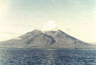
Damer, or Damar,, also called Kenli Island, is a small volcanic island in the Barat Daya Islands group in Indonesia's Maluku province, on the southern side of the Banda Sea. It is flanked by four smaller uninhabited islands - one to the east (Layeni), one to the west and two to the south. Together they are called the Damar Islands, and constitute one administrative district within the Maluku Barat Daya Regency. The district has a land area of 201.80 km2 and had a population of 5,718 at the 2020 Census; the official estimate as at mid 2023 was 6,362, all on Damer Island itself.
Wetan Island is an island, part of the Babar Islands, in the Moluccas, Indonesia. Its people speak the Wetan language. A species of moth was discovered on the island and named for it.
Jemaja Island is the most westerly of the main islands in the Anambas Islands Regency, part of the province of Riau Islands within Indonesia. The island is administered as three districts of the regency.
Nyata is an island in the Barat Daya Islands in the Banda Sea. It is northwest of Romang, in the Banda Sea.

Tiakur is a kelurahan and the regency seat of Southwest Maluku Regency in Maluku, Indonesia. The town was purposely built as the capital of the Southwest Maluku Regency following its creation in 2008. It was created as the result of a political debate during the creation of the regency, although smaller than the larger and more developed town of the regency, Wonreli on Kisar Island. The town is located mainly within the boundaries of Tiakur kelurahan, with a population of 4,227 as of 2022.

