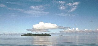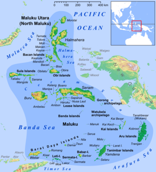
The Banda Sea is one of four seas that surround the Maluku Islands of Indonesia, connected to the Pacific Ocean, but surrounded by hundreds of islands, including Timor, as well as the Halmahera and Ceram Seas. It is about 1000 km (600 mi) east to west, and about 500 km (300 mi) north to south.

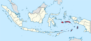
Maluku is a province of Indonesia. It comprises the central and southern regions of the Maluku Islands. The largest city and capital of Maluku province is Ambon on the small Ambon Island. It is directly adjacent to North Maluku, Southwest Papua, and West Papua in the north, Central Sulawesi, and Southeast Sulawesi in the west, Banda Sea, Australia, East Timor and East Nusa Tenggara in the south and Arafura Sea, Central Papua and South Papua in the east. The land area is 57803.81 km2, and the total population of this province at the 2010 census was 1,533,506 people, rising to 1,848,923 at the 2020 census, the official estimate as at mid 2023 was 1,908,753. Maluku is located in Eastern Indonesia.

The Babar Islands(Indonesian: Kepulauan Babar) are located in Maluku Province, Indonesia between latitudes 7 degrees 31 minutes South to 8 degrees 13 minutes South and from longitudes 129 degrees 30 minutes East to 130 degrees 05 minutes East. The group now constitutes five districts (kecamatan) within the Maluku Barat Daya Regency of Maluku province.

Wetar is a tropical island which belongs to the Indonesian province of Maluku and is the largest island of the Maluku Barat Daya Islands Regency of the Maluku Islands. It lies east of the Lesser Sunda Islands, which include nearby Alor and Timor, but it is politically part of the Maluku Islands. To the south, across the Wetar Strait, lies the island of Timor; at its closest it is 50 km away. To the west, across the Ombai Strait, lies the island of Alor. To the southwest is the very small island of Liran, which is also part of West Wetar District and, further southwest, the small East Timorese island of Atauro. To the north is the Banda Sea and to the east lie Romang and Damar Islands, while to the southeast lie the other principal islands of the Barat Daya Islands. Including Liran and other small offshore islands, Wetar has an area of 2,651.8 km2, and had a population of 7,916 at the 2010 Census and 8,622 at the 2020 Census; the official estimate as at mid 2023 was 11,109. Administratively, Wetar is divided into four of the districts (kecamatan) of the Maluku Barat Daya Regency.

Kisar, also known as Yotowawa, is a small island in the Southwestern Moluccas in Indonesia, located to the northeast of Timor Island. The island now forms two districts within the Southwest Islands Regency of Maluku Province. South Kisar District was previously called Kecamatan Pulau Pulau Terselatan and at one time included the larger Roma or Romang Island further north, but this with its own outliers was subsequently split off to form its own district. The rest of the island forms the North Kisar District within the regency. It is one of the 92 officially listed outlying islands of Indonesia. The principal town is Wonreli, with 6,652 inhabitants at the 2010 Census.

Liran is a small island off the southwest coast of Wetar Island, Indonesia. Administratively it is part of West Wetar District within the Southwest Maluku Regency. The East Timorese island Atauro is 12 km to the southwest. Liran is the westernmost of the Barat Daya Islands in the province of Maluku. It covers an area of 39.14 km2 and had 841 inhabitants in 2019.

The Letti Islands of Indonesia are part of the Maluku Islands, in southwest Maluku Province. They are also called the "Lemola" Archipelago, from the initial two letters of each of the three main islands, Letti, Moa and Lakor; each of the three islands now constitutes a separate administrative district (kecamatan) within the Maluku Barat Daya Regency

Romang is an island, part of the Barat Daya Islands in Indonesia, located at 7.5833333°S 127.4333333°E, east of Wetar Island. Alternate names in use are Roma, Romonu and Fataluku. The group includes neighbouring smaller islands including Nyata to the west, Mitan to the south, and Maopora, Tellang, Laut, Limtutu and Djuha Islands to the east. Together they form the Kepulauan Roma District within the Barat Daya Islands Regency of the Maluku Province. The district covers a land area of 194.30 km2 and had a population of 4,430 in mid 2023.

The rose-crowned fruit dove, also known as pink-capped fruit dove or Swainson's fruit dove, is a medium-sized fruit dove that is found in parts of southern Indonesia, northern Australia and eastern Australia.
The Timoric languages are a group of Austronesian languages spoken on the islands of Timor, neighboring Wetar, and Southwest Maluku to the east.

The Banda Sea Islands moist deciduous forests is a tropical moist forest ecoregion in Indonesia. The ecoregion includes several island groups in the southwestern Banda Sea, including the Tanimbar Islands, Kai Islands, and the Barat Daya Islands except for Wetar.
South Halmahera Regency is a regency of North Maluku Province, Indonesia. It lies partly on Halmahera Island and partly on smaller islands to the west and south of Halmahera. It covers a land area of 8,779.32 km2, and at the 2010 Census it had a population of 198,911 people, while the 2020 Census showed that this had risen to 248,395 and the official estimate in mid 2023 was 255,384 The capital lies at the town of Labuha on Bacan Island.

Southwest Maluku Regency is a regency of Maluku Province, Indonesia. Geographically it forms the most eastern portion of the Lesser Sunda Islands, although it has never been administratively included with them, and politically has always comprised a part of the Maluku Province. It comprises a number of islands and island groups in the south of the province, including Lirang Island, Wetar Island, Kisar Island, Romang Island, the Letti Islands, the Damer Islands, the Sermata Islands and the Babar Islands. The total land area is 4,581.06 km2, and the population was 70,714 at the 2010 Census and 81,928 at the 2020 Census; the official estimate as at mid 2023 was 93,766.

Tanimbar Islands Regency is a regency of Maluku province, Indonesia, consisting primarily of the Tanimbar Islands. The Regency covers a land area of 10,102 km2, and it had a population of 105,341 at the 2010 Census and 123,572 at the 2020 Census; the official estimate as at mid 2022 was 124,787. The principal town and administrative centre lies at Saumlaki in Tanimbar Selatan District.

Troides staudingeri is a birdwing butterfly in the genus Troides in the family Papilionidae. It is known from Leti Island, Moa Island, Kisar Island, Babar Island and Wetar Island.
Pulau-Pulau Terselatan is a district (Kecamatan) in the Maluku Barat Daya regency (kabupaten) of the province of Maluku, Indonesia. The district includes the islands of Kisar and Romang, with the surrounding small islands of Njata, Mitan, Tellang, Limtutu, Loud, Kital, Maopora and Djuha; all lie to the east of the larger island of Wetar. The main town is Wonreli on Kisar Island.

Damer, or Damar,, also called Kenli Island, is a small volcanic island in the Barat Daya Islands group in Indonesia's Maluku province, on the southern side of the Banda Sea. It is flanked by four smaller uninhabited islands - one to the east (Layeni), one to the west and two to the south. Together they are called the Damar Islands, and constitute one administrative district within the Maluku Barat Daya Regency, lying on the undersea ridge which forms the most easterly extension of the Lesser Sunda Islands. Continuing the line of the ridge further to the northeast are several small and remote islands at increasing distances from Damer Island; these are Teon Island, Nila Island, tiny 'Nil Desperandum' islet, Serua Island and - far to the north and administered as part of Maluku Tengah Regency - Manuk Island; all of these far-flung islands are isolated stratovolcanoes and are uninhabited. The district has a combined land area of 201.80 km2 and had a population of 5,718 at the 2020 Census; the official estimate as at mid 2023 was 6,362, all on Damer Island itself.

Tiakur is a kelurahan and the regency seat of Southwest Maluku Regency in Maluku, Indonesia. The town was purposely built as the capital of the Southwest Maluku Regency following its creation in 2008. It was created as the result of a political debate during the creation of the regency, although smaller than the larger and more developed town of the regency, Wonreli on Kisar Island. The town is located mainly within the boundaries of Tiakur kelurahan, with a population of 4,227 as of 2022.


