Related Research Articles

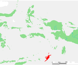
The Banda Islands are a volcanic group of ten small volcanic islands in the Banda Sea, about 140 km (87 mi) south of Seram Island and about 2,000 km (1,243 mi) east of Java, and constitute an administrative district (kecamatan) within the Central Maluku Regency in the Indonesian province of Maluku. The islands rise out of 4-to-6-kilometre deep ocean and have a total land area of approximately 172 square kilometres (66 sq mi). They had a population of 18,544 at the 2010 Census and 20,924 at the 2020 Census. Until the mid-19th century the Banda Islands were the world's only source of the spices nutmeg and mace, produced from the nutmeg tree. The islands are also popular destinations for scuba diving and snorkeling. The main town and administrative centre is Bandanaira, located on the island of the same name.

Nisswa is a city in Crow Wing County, Minnesota, United States. The population was 1,971 at the 2010 census. Nisswa is part of the Brainerd Micropolitan Statistical Area, near Gull Lake.
The Tanimbar Islands, also called Timur Laut, are a group of about 65 islands in the Maluku province of Indonesia. The largest and most central of the islands is Yamdena; others include Selaru to the southwest of Yamdena, Larat and Fordata to the northeast, Maru and Molu to the north, and Seira, Wuliaru, Selu, Wotap and Makasar to the west. The Indonesian phrase timur laut means "east of the sea" or "northeast".

The Barat Daya Islands are a group of islands in the Maluku province of Indonesia. The Indonesian phrase barat daya means 'south-west'.

The Savu Sea is a small sea within Indonesia named for the island of Savu (Sawu) on its southern boundary. It is bounded by Savu and Rai Jua to the south, the islands of Rote and Timor to the east, Flores and the Alor archipelago to the north/northwest, and the island of Sumba to the west/northwest. Between these islands, it flows into the Indian Ocean to the south and west, the Flores Sea to the north, and the Banda Sea to the northeast.
Jökulsárgljúfur National Park is a former national park situated in the north of Iceland around the river Jökulsá á Fjöllum. It lies to the north of the Dettifoss waterfall. On 7 June 2008, it became a part of the larger Vatnajökull National Park.

The Banda Sea is one of four seas that surround the Maluku Islands of Indonesia, connected to the Pacific Ocean, but surrounded by hundreds of islands, including Timor, as well as the Halmahera and Ceram Seas. It is about 1000 km (600 mi) east to west, and about 500 km (300 mi) north to south.

Hamyang County (Hamyang-gun) is a county in South Gyeongsang Province, South Korea.

The Flores Sea covers 240,000 square kilometres (93,000 sq mi) of water in Indonesia. The sea is bounded on the north by the island of Celebes and on the south by Sunda Islands of Flores and Sumbawa.

The Letti Islands of Indonesia are part of the Maluku Islands, in southwest Maluku Province. They are also called the "Lemola" Archipelago, from the initial two letters of each of the three main islands, Letti, Moa and Lakor; each of the three islands now constitutes a separate administrative district (kecamatan) within the Maluku Barat Daya Regency
Isola dei Pescatori is an island in Lake Maggiore in northern Italy. As the most northerly of the three principal Borromean Islands it is also known as Isola Superiore and, with a population of 25 in 2018, it is the only one to be inhabited all year round. Unlike Isola Bella and Isola Madre, the island has never belonged to the Borromeo family.
The 1938 Banda Sea earthquake occurred on February 1 with an estimated magnitude of 8.4 on the moment magnitude scale and a Rossi–Forel intensity of VII. This oblique-slip event generated destructive tsunamis of up to 1.5 metres in the Banda Sea region, but no human lives were lost.

The Banda Sea Plate is a minor tectonic plate underlying the Banda Sea in southeast Asia. This plate also carries a portion of Sulawesi Island, the entire Seram Island, and the Banda Islands. Clockwise from the east it is bounded by the Bird's Head Plate of western New Guinea, Australian Plate, Timor Plate, Sunda Plate, and the Molucca Sea Collision Zone.
Tapilkajmy is a village in the administrative district of Gmina Bartoszyce, within Bartoszyce County, Warmian-Masurian Voivodeship, in northern Poland, close to the border with the Kaliningrad Oblast of Russia. It lies approximately 11 kilometres (7 mi) north-west of Bartoszyce and 57 km (35 mi) north of the regional capital Olsztyn.
The Timor Trough is an oceanic trough that is a continuation of the Sunda Trench that marks the boundary between the Indo-Australian Plate and the Timor Plate. It is separated from the Sunda Trench by a sag near Sumba Island at the Scott Plateau and the North Australian Basin, and on the other end becomes the Tanimbar Trough southeast of the Tanimbar Islands, continuing on to the Aru Trough east of the Kai Islands near the Bird's Head Peninsula on New Guinea. Lining the north of the trough are numerous islands, of which Timor is the largest. Further west are the Weber Basin and the Banda Trench. Oil and natural gas have been found in the Bonaparte Basin south of the trough and the region is geologically active with numerous earthquakes.

The Großer Jasmunder Bodden belongs to the Northern Rügener Boddens and is a water body on the southern edge of the Baltic Sea in the German state of Mecklenburg-Vorpommern. It is a bodden, a type of lagoon that occurs in northern Europe especially on the coast of Pomerania. It lies within the island of Rügen, is around 14 kilometres long, an average of six kilometres wide and is up to nine metres deep with an average depth of 5.3m. The Großer Jasmunder Bodden has an area of 58.6 square kilometres; if the Breetzer Bodden, Breeger Bodden, Lebbiner Bodden, Neuendorfer Wiek and Tetzitzer See are included the total area of water comes to over 94 square kilometres.
The 1629 Banda Sea earthquake struck the Banda Sea, Indonesia on August 1. Its epicentre is believed to have been in the Seram Trough. A megathrust earthquake caused a 15 m (49 ft) tsunami, which was recorded to have affected the Banda Islands about 30 minutes after the quake. The effects of the tsunami were reported as far as 230 kilometres (140 mi) away in Ambon. Many trees in the Banda Islands were reported to have been uprooted.
Marionia elongoreticulata is a species of sea slug, a dendronotid nudibranch, a marine gastropod mollusc in the family Tritoniidae.
The 1852 Banda Sea earthquake struck on 26 November 1852 at 07:40 local time, affecting coastal communities on the Banda Islands. The earthquake had an estimated moment magnitude of 7.5 or 8.4–8.8. It caused violent shaking lasting five minutes, and was assigned IX on the Modified Mercalli intensity scale in the Maluku Islands. A tsunami measuring up to 8 meters slammed into the islands of Banda Neira, Saparua, Haruku and Ceram. The tsunami caused major damage, washing away many villages, ships and residents. At least 60 people were killed in the earthquake and tsunami.
References
Coordinates: 07°31′14″S127°17′19″E / 7.52056°S 127.28861°E
| | This article about an island is a stub. You can help Wikipedia by expanding it. |
| | This article about a location in Maluku Province is a stub. You can help Wikipedia by expanding it. |