Flores is one of the Lesser Sunda Islands, a group of islands in the eastern half of Indonesia. Including Komodo Island off its west coast, the land area is 15,530.58 km2, and the population was 1,878,875 in the 2020 Census ; the official estimate as at mid 2022 was 1,919,395. The largest towns are Maumere and Ende. The name Flores is of Portuguese origin, meaning "Flowers".

Indonesia is an archipelagic country located in Southeast Asia and Oceania, lying between the Indian Ocean and the Pacific Ocean. It is located in a strategic location astride or along major sea lanes connecting East Asia, South Asia and Oceania. Indonesia is the largest archipelago in the world. Indonesia's various regional cultures have been shaped—although not specifically determined—by centuries of complex interactions with its physical environment.

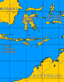
Sumbawa is an Indonesian island, located in the middle of the Lesser Sunda Islands chain, with Lombok to the west, Flores to the east, and Sumba further to the southeast. Along with Lombok, it forms the province of West Nusa Tenggara, but there have been plans by the Indonesian government to split the island off into a separate province. Traditionally, the island is known as the source of sappanwood, as well as honey and sandalwood. Its savanna-like climate and vast grasslands are used to breed horses and cattle, as well as to hunt deer.

Timor is an island at the southern end of Maritime Southeast Asia, in the north of the Timor Sea. The island is divided between the sovereign states of East Timor on the eastern part and Indonesia on the western part. The Indonesian part, known as West Timor, constitutes part of the province of East Nusa Tenggara. Within West Timor lies an exclave of East Timor called Oecusse District. The island covers an area of 30,777 square kilometres. The name is a variant of timur, Malay for "east"; it is so called because it lies at the eastern end of the Lesser Sunda Islands. Mainland Australia is less than 500 km away, separated by the Timor Sea.

Alor is the largest island in the Alor Archipelago and is one of the 92 officially listed outlying islands of Indonesia. It is located at the eastern Lesser Sunda Islands that runs through southeastern Indonesia, which from the west include such islands as Bali, Lombok, Sumbawa, Komodo, and Flores.

West Nusa Tenggara is a province of Indonesia. It comprises the western portion of the Lesser Sunda Islands, with the exception of Bali which is its own province. Mataram, on Lombok, is the capital and largest city of the province. It shares maritime borders with Bali to the west and East Nusa Tenggara to the east. The 2010 census recorded the population at 4,500,212; the total rose to 4,830,118 at the 2015 Intermediate Census and 5,320,092 at the 2020 census; the official estimate as at mid 2022 was 5,473,671. The province's area is 20,153.15 km2. The two largest islands by far in the province are Lombok in the west and the larger Sumbawa island in the east.

The Sunda Islands are a group of islands in the Malay Archipelago. They consist of the Greater Sunda Islands and the Lesser Sunda Islands

The Barat Daya Islands are a group of islands in the Maluku province of Indonesia. The Indonesian phrase barat daya means 'south-west'.

Wallacea is a biogeographical designation for a group of mainly Indonesian islands separated by deep-water straits from the Asian and Australian continental shelves. Wallacea includes Sulawesi, the largest island in the group, as well as Lombok, Sumbawa, Flores, Sumba, Timor, Halmahera, Buru, Seram, and many smaller islands. The islands of Wallacea lie between the Sunda Shelf to the west, and the Sahul Shelf including Australia and New Guinea to the south and east. The total land area of Wallacea is 347,000 km2 (134,000 sq mi).

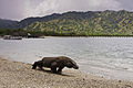
Komodo is one of the 17,508 islands that comprise the Republic of Indonesia. It is particularly notable as the habitat of the Komodo dragon, the largest lizard on Earth, which is named after the island. Komodo Island has a surface area of 291 square kilometres, and had a human population of about 1,800 in 2020.
Geologically, the Sunda Shelf is a south-eastern extension of the continental shelf of Mainland Southeast Asia. Major landmasses on the shelf include Bali, Borneo, Java, Madura, and Sumatra, as well as their surrounding smaller islands. It covers an area of approximately 1.85 million km2. Sea depths over the shelf rarely exceed 50 metres and extensive areas are less than 20 metres resulting in strong bottom friction and strong tidal friction. Steep undersea gradients separate the Sunda Shelf from the Philippines, Sulawesi, and the Lesser Sunda Islands.
The Central Malayo-Polynesian languages (CMP) are a proposed branch in the Malayo-Polynesian subgroup of the Austronesian language family. The languages are spoken in the Lesser Sunda and Maluku Islands of the Banda Sea, in an area corresponding closely to the Indonesian provinces of East Nusa Tenggara and Maluku and the nation of East Timor, but with the Bima language extending to the eastern half of Sumbawa Island in the province of West Nusa Tenggara and the Sula languages of the Sula archipelago in the southwest corner of the province of North Maluku. The principal islands in this region are Sumbawa, Sumba, Flores, Timor, Buru, and Seram. The numerically most important languages are Bima, Manggarai of western Flores, Uab Meto of West Timor, and Tetum, the national language of East Timor.

Trimeresurus insularis or Indonesian pit viper, Lesser Sunda Islands pit viper, Sunda white-lipped pit viper, red-tailed pit viper is a venomous pit viper species found in eastern Java and the Lesser Sunda Islands, Indonesia.

The Alas Strait is a strait that separates Lombok and Sumbawa, two islands of Indonesia in West Nusa Tenggara province.

The Lesser Sundas deciduous forests is a tropical dry forest ecoregion in Indonesia. The ecoregion includes the islands of Lombok, Sumbawa, Komodo, Flores, and Alor, along with the many adjacent smaller islands.
The Timor and Wetar deciduous forests is a tropical dry forest ecoregion in Indonesia and East Timor. The ecoregion includes the islands of Timor, Wetar, Rote, Savu, and adjacent smaller islands.