
Oceanic trenches are prominent, long, narrow topographic depressions of the ocean floor. They are typically 50 to 100 kilometers wide and 3 to 4 km below the level of the surrounding oceanic floor, but can be thousands of kilometers in length. There are about 50,000 km (31,000 mi) of oceanic trenches worldwide, mostly around the Pacific Ocean, but also in the eastern Indian Ocean and a few other locations. The greatest ocean depth measured is in the Challenger Deep of the Mariana Trench, at a depth of 10,920 m (35,830 ft) below sea level.
Subduction is a geological process in which the oceanic lithosphere and some continental lithosphere is recycled into the Earth's mantle at convergent boundaries. Where the oceanic lithosphere of a tectonic plate converges with the less dense lithosphere of a second plate, the heavier plate dives beneath the second plate and sinks into the mantle. A region where this process occurs is known as a subduction zone, and its surface expression is known as an arc-trench complex. The process of subduction has created most of the Earth's continental crust. Rates of subduction are typically measured in centimeters per year, with rates of convergence as high as 11 cm/year.
Obduction is a geological process whereby denser oceanic crust is scraped off a descending ocean plate at a convergent plate boundary and thrust on top of an adjacent plate. When oceanic and continental plates converge, normally the denser oceanic crust sinks under the continental crust in the process of subduction. Obduction, which is less common, normally occurs in plate collisions at orogenic belts or back-arc basins.

The Ring of Fire is a tectonic belt of volcanoes and earthquakes.

A convergent boundary is an area on Earth where two or more lithospheric plates collide. One plate eventually slides beneath the other, a process known as subduction. The subduction zone can be defined by a plane where many earthquakes occur, called the Wadati–Benioff zone. These collisions happen on scales of millions to tens of millions of years and can lead to volcanism, earthquakes, orogenesis, destruction of lithosphere, and deformation. Convergent boundaries occur between oceanic-oceanic lithosphere, oceanic-continental lithosphere, and continental-continental lithosphere. The geologic features related to convergent boundaries vary depending on crust types.

The Barat Daya Islands are a group of islands in the Maluku province of Indonesia. The Indonesian phrase barat daya means 'south-west'.

The Banda Sea is one of four seas that surround the Maluku Islands of Indonesia, connected to the Pacific Ocean, but surrounded by hundreds of islands, including Timor, as well as the Halmahera and Ceram Seas. It is about 1000 km (600 mi) east to west, and about 500 km (300 mi) north to south.

The Australian Plate is a major tectonic plate in the eastern and, largely, southern hemispheres. Originally a part of the ancient continent of Gondwana, Australia remained connected to India and Antarctica until approximately 100 million years ago when India broke away and began moving north. Australia and Antarctica had begun rifting by 96 million years ago and completely separated a while after this, some believing as recently as 45 million years ago, but most accepting presently that this had occurred by 60 million years ago.
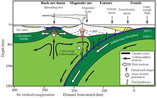
Forearc is a plate tectonic term referring to a region in a subduction zone between an oceanic trench and the associated volcanic arc. Forearc regions are present along convergent margins and eponymously form 'in front of' the volcanic arcs that are characteristic of convergent plate margins. A back-arc region is the companion region behind the volcanic arc.
A volcanic arc is a belt of volcanoes formed above a subducting oceanic tectonic plate, with the belt arranged in an arc shape as seen from above. Volcanic arcs typically parallel an oceanic trench, with the arc located further from the subducting plate than the trench. The oceanic plate is saturated with water, mostly in the form of hydrous minerals such as micas, amphiboles, and serpentines. As the oceanic plate is subducted, it is subjected to increasing pressure and temperature with increasing depth. The heat and pressure break down the hydrous minerals in the plate, releasing water into the overlying mantle. Volatiles such as water drastically lower the melting point of the mantle, causing some of the mantle to melt and form magma at depth under the overriding plate. The magma ascends to form an arc of volcanoes parallel to the subduction zone.
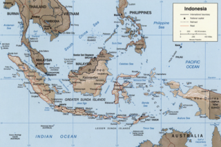
The Sunda Arc is a volcanic arc that produced the volcanoes that form the topographic spine of the islands of Sumatra, Nusa Tenggara, Java, the Sunda Strait, and the Lesser Sunda Islands. The Sunda Arc begins at Sumatra and ends at Flores, and is adjacent to the Banda Arc. The Sunda Arc is formed via the subduction of the Indo-Australian Plate beneath the Sunda and Burma plates at a velocity of 63–70 mm/year.

The Sunda Plate is a minor tectonic plate straddling the Equator in the Eastern Hemisphere on which the majority of Southeast Asia is located.
In geology, continental collision is a phenomenon of plate tectonics that occurs at convergent boundaries. Continental collision is a variation on the fundamental process of subduction, whereby the subduction zone is destroyed, mountains produced, and two continents sutured together. Continental collision is only known to occur on Earth.

Located in the western Pacific Ocean near Indonesia, the Molucca Sea Plate has been classified by scientists as a fully subducted microplate that is part of the Molucca Sea Collision Complex. The Molucca Sea Plate represents the only known example of divergent double subduction (DDS), which describes the subduction on both sides of a single oceanic plate.
This is a list of articles related to plate tectonics and tectonic plates.

In the geology of the Philippines, the Philippine Mobile Belt is a complex portion of the tectonic boundary between the Eurasian Plate and the Philippine Sea Plate, comprising most of the country of the Philippines. It includes two subduction zones, the Manila Trench to the west and the Philippine Trench to the east, as well as the Philippine Fault System. Within the Belt, a number of crustal blocks or microplates which have been shorn off the adjoining major plates are undergoing massive deformation.
The Antarctic Peninsula, roughly 1,000 kilometres (650 mi) south of South America, is the northernmost portion of the continent of Antarctica. Like the associated Andes, the Antarctic Peninsula is an excellent example of ocean-continent collision resulting in subduction. The peninsula has experienced continuous subduction for over 200 million years, but changes in continental configurations during the amalgamation and breakup of continents have changed the orientation of the peninsula itself, as well as the underlying volcanic rocks associated with the subduction zone.

The Kutai sedimentary basin extends from the central highlands of Borneo, across the eastern coast of the island and into the Makassar Strait. With an area of 60,000 km2, and depths up to 15 km, the Kutai is the largest and deepest Tertiary age basin in Indonesia. Plate tectonic evolution in the Indonesian region of SE Asia has produced a diverse array of basins in the Cenozoic. The Kutai is an extensional basin in a general foreland setting. Its geologic evolution begins in the mid Eocene and involves phases of extension and rifting, thermal sag, and isostatic subsidence. Rapid, high volume, sedimentation related to uplift and inversion began in the Early Miocene. The different stages of Kutai basin evolution can be roughly correlated to regional and local tectonic events. It is also likely that regional climate, namely the onset of the equatorial ever wet monsoon in early Miocene, has affected the geologic evolution of Borneo and the Kutai basin through the present day. Basin fill is ongoing in the lower Kutai basin, as the modern Mahakam River delta progrades east across the continental shelf of Borneo.

The Lesser Sunda Islands, also known as Nusa Tenggara Islands, are an archipelago in Maritime Southeast Asia, most of the Lesser Sunda Islands are located within the Wallacea region, except for the Bali province which is west of the Wallace Line and is within the Sunda Shelf. Together with the Greater Sunda Islands to the west they make up the Sunda Islands. The islands are part of a volcanic arc, the Sunda Arc, formed by subduction along the Sunda Trench in the Java Sea. Slightly over 20 million people live on the islands. Etymologically, Nusa Tenggara means "Southeast Islands" from the words of nusa which means 'island' from Old Javanese language and tenggara means 'southeast'.
Flores Back Arc Thrust Fault is a major system of west–east trending thrust faults that extend eastwards from west of Lombok just south of where Sunda Shelf ends at Bali Sea, towards the islands of Sumbawa, Flores, and Alor, with a total length of at least 800 km., entering the Weber Basin and Aru Basin adjacent Sahul Shelf of the Australian plate. The thrust faults are south-dipping and lie within the back arc region of the Sunda-Banda Arc, which is related to the ongoing subduction of the Australian Plate beneath the Sunda and Banda Sea Plates. The thrust fault system developed as a result of the onset of continental collision as continental crust of the Australian Plate reached the Sunda Trench. The eastern part of the fault system is also known as the Wetar thrust. Above the main thrust fault are a series of imbricate (overlapping) thrust faults. These imbricate thrust faults are shallower in depth than the main Flores thrust. Although the exact thrust faults have not been established, these faults were thought to be responsible for the 2018 Lombok earthquakes.

