Rote Island

Last updated
Rote Island
Rote (Island) 123.05527E 10.71620S.png
Satellite photo of Rote.
Rote Island en.png
Map of Rote.
Rote Island
Geography
Location Southeast Asia
Administration
Province East Nusa Tenggara
Regency Rote Ndao
Additional information
Time zone

Rote Island (Indonesian : Pulau Rote, also spelled Roti) is an island of Indonesia, part of the East Nusa Tenggara province of the Lesser Sunda Islands. According to legend, this island got its name accidentally when a lost Portuguese sailor arrived and asked a farmer where he was. The surprised farmer, who could not speak Portuguese, introduced himself, "Rote".

Contents

Geography

Rote lies 500 km (310.686 miles) northwest of the Australian coast and 150 km (105.633 miles) north of the Ashmore and Cartier Islands. The island is situated to the southwest of the larger island of Timor. To the north is the Savu Sea, and to the south is the Timor Sea. To the west lie Savu and Sumba. The uninhabited Pamana (or Ndana) island, just south of Rote, with an area of 14 km2 (5 sq mi), is the southernmost island of Indonesia. Along with some other nearby small islands, such as Nuse Island and Ndao island to the west of Rote, it forms the kabupaten (regency) of Rote Ndao Regency, which in the 2020 decennial census recorded a population of 143,764; [1] the official estimate as at mid 2022 was 148,811. [2] Rote island has an area of 1,280.10 km2 (494 sq mi) (including offshore islands).

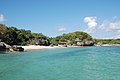
The main town, Ba'a, is located on the northern side of the island. Rote has a good surf area in the south, around the village of Nembrala.

For the most part, the island is covered by grassland and palms. This island experiences tropical savanna climate (Aw) with dry months for much of the year because of the dry winds that blow from mainland Australia. The main rainfall usually occurs between November and March. Between 80% and 95% of all rain falls during the wet west monsoon period and with little or no rain falling between July and October. The mean rainfall for Rote Island is around 1,200 to 1,300 mm annually. During the dry season, many streams and rivers run dry and local inhabitants must rely only on wells for their water supplies.

Geology

Rote is the youngest island of the Banda Fore Arc. The Banda Fore Arc is an accretionary wedge forming in response to an arc continent collision between oceanic crust of the Eurasian Plate and the Australian Plate. As the Australian continental shelf subducts under the Banda Arc, marine sediment is transferred to the upper plate, forming and accretionary wedge. Most of the wedge is submarine, but some parts are exposed above sea level forming the islands of Sumba, Savu, Rote and Timor [3] .

Rote and Savu are the youngest of these islands. Researchers have investigated the biostratigraphy of microfossils to time the uplift of these islands and the rate at which they rose from below sea level. Planktonic microorganisms called Foraminifera build shells of calcite. When they die, their shells accumulate on the seafloor as thick sequences of chalk. Chalk forms in deep marine, low energy environments. The Neogene Batu Putih Formation is a deposit of chalk, 100s of meters thick, that accumulated on top of the Banda Fore Arc accretionary wedge. This chalk is exposed at the surface on Rote and Savu [3] .

By studying the faunal succession and thickness of chalk deposits, researchers have determined that the accretionary wedge began forming at least 5.6 million years ago. Rote rose to the surface around 200,000 years ago, half a million years after nearby Savu, from a depth of at least 2.5 km below sea level, at an average rate of 0.6 mm/year over the past 5.2 million years. Over the last 125,000 years that rate has increased to almost 1.4 mm/year. Changes in the rates in uplift is hypothesized to be a consequence of the subduction of the Scott Plateau of the Australian passive margin. More work is needed to understand the crustal and tectonic mechanisms that are at play in the development of the Rote and Savu islands [3] .

Transportation

There is a daily ferry to the island from Kupang, the provincial capital on West Timor, which provides transport for local passengers and goods as well as tourists. The trip between Kupang and Ba'a takes around two hours. The ferry leaves at 8.30 AM and costs 80,000 Indonesian rupiah. Fare in 2023 is 202,000 IDR. [4]

Wings Air operates daily flights between Rote's David Constantijn Saudale Airport and Kupang's El Tari International Airport. Flight time is about 30 minutes.

Rote consists of rolling hills, terraced plantations, acacia palm, savanna and some forests.

Economy

Town Market in Ba'a, Rote Baa Market Rote.jpg
Town Market in Ba'a, Rote

The Rotinese depend, like the Savunese, on the lontar palm not only for basic survival but also as a supplement to their income from fishing and jewelry making.

Agriculture is the main form of employment. Fishing is also important, especially in the eastern village of Papela (east of Londalusi in the map), which has led to disputes with Australia over the water between them. [5]

Tourist attractions

Rote has many historical relics including fine antique Chinese porcelain, as well as ancient arts and traditions. Several prominent Indonesian figures were born in Rote. A popular music instrument, Sasando, is made of palm leaves.

In the eastern part of the island is a pond in Landu Village that has non-poisonous jellyfish. The pond also has a white sandy beach. [6]

Rote Island, also known as Rote Ndao, is an island consisting of 96 small islands and 6 of them are inhabited. Many islands have natural beaches and other natural and frequent tourism, but so far only local tourists often come to Rote. 10 of the most famous tourist attractions in Rote that are Bo'a beach, Nemberala beach, [7] Lutu Babatu beach, Falii water located in West Rote, Oesosole beach in East Rote, Termanu stone in central Rote, Laguna Nirwana in Southwest Rote, Oekode Waterfall, Zero Point Rote and Inaoe beach in South Rote. [8]

Culture

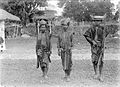
The ti'i langga is a traditional hat with a horn-like protrusion at the top that is a symbol of Rote cultural identity. [9]

There are many languages spoken on the island, all related to the languages on nearby Timor island. These languages are: Bilba, Dengka, Lole, Ringgou, Dela-Oenale, Termanu, and Tii.

Trivia

The critically endangered Rote Island snake-necked turtle is endemic to Rote Island.

The US-born Australian scholar, James J. Fox, has written extensively about Rotinese culture.

See also

Related Research Articles

<span class="mw-page-title-main">Timor</span> Island in Indonesia and East Timor

Timor is an island at the southern end of Maritime Southeast Asia, in the north of the Timor Sea. The island is divided between the sovereign states of East Timor on the eastern part and Indonesia on the western part. The Indonesian part, known as West Timor, constitutes part of the province of East Nusa Tenggara. Within West Timor lies an exclave of East Timor called Oecusse District. The island covers an area of 30,777 square kilometres. The name is a variant of timur, Malay for "east"; it is so called because it lies at the eastern end of the Lesser Sunda Islands. Mainland Australia is less than 500 km away, separated by the Timor Sea.

<span class="mw-page-title-main">East Nusa Tenggara</span> Province of Indonesia

East Nusa Tenggara is the southernmost province of Indonesia. It comprises the eastern portion of the Lesser Sunda Islands, facing the Indian Ocean in the south and the Flores Sea in the north. It consists of more than 500 islands, with the largest ones being Sumba, Flores, and the western part of Timor; the latter shares a land border with the separate nation of East Timor. The province is subdivided into twenty-one regencies and the regency-level city of Kupang, which is the capital and largest city.

<span class="mw-page-title-main">Sunda Islands</span> Island group in the Malay Archipelago

The Sunda Islands are a group of islands in the Malay Archipelago. They consist of the Greater Sunda Islands and the Lesser Sunda Islands.

<span class="mw-page-title-main">Savu Sea</span> A small sea within Indonesia

The Savu Sea is a small sea within Indonesia named for the island of Savu (Sawu) on its southern boundary. It is bounded by Savu and Rai Jua to the south, the islands of Rote and Timor to the east, Flores and the Alor archipelago to the north/northwest, and the island of Sumba to the west/northwest. Between these islands, it flows into the Indian Ocean to the south and west, the Flores Sea to the north, and the Banda Sea to the northeast.

<span class="mw-page-title-main">Banda Sea</span> A sea between Sulawesi and Maluku

The Banda Sea is one of four seas that surround the Maluku Islands of Indonesia, connected to the Pacific Ocean, but surrounded by hundreds of islands, including Timor, as well as the Halmahera and Ceram Seas. It is about 1000 km (600 mi) east to west, and about 500 km (300 mi) north to south.

<span class="mw-page-title-main">Forearc</span> The region between an oceanic trench and the associated volcanic arc

Forearc is a plate tectonic term referring to a region in a subduction zone between an oceanic trench and the associated volcanic arc. Forearc regions are present along convergent margins and eponymously form 'in front of' the volcanic arcs that are characteristic of convergent plate margins. A back-arc region is the companion region behind the volcanic arc.

<span class="mw-page-title-main">Kisar</span> Island in Indonesia

Kisar, also known as Yotowawa, is a small island in the Southwestern Moluccas in Indonesia, located to the northeast of Timor Island. Most of the island is included within the Southernmost Islands District within the Southwest Islands Regency of Maluku Province. The District previously also includes the larger Romang Island further north, but this with its own outliers was subsequently split off to form its own district. The rest of the island forms the North Kisar District within the regency. It is one of the 92 officially listed outlying islands of Indonesia. The principal town is Wonreli, with 6,652 inhabitants at the 2010 Census.

<span class="mw-page-title-main">Savu</span> Island in Indonesia

Savu is the largest of a group of three islands, situated midway between Sumba and Rote, west of Timor, in Indonesia's eastern province, East Nusa Tenggara. Ferries connect the islands to Waingapu on Sumba, Ende on Flores, and Kupang in West Timor. Flying to Savu through Susi Air from Kupang, Ende, and Waingapu is also possible.

<span class="mw-page-title-main">Derawan Islands</span> Island group in Indonesia

The Derawan Islands are in the province of East Kalimantan in Indonesia. They consist of 31 islands, most well known among these are the islands of Derawan, Kakaban, Maratua, and Sangalaki. There are also numerous submerged reefs and islets. They are located in the Sulawesi Sea, on the coastal shelf of East Kalimantan. The islands are part of the Berau Regency.

<span class="mw-page-title-main">Weh Island</span> Island in Aceh, Indonesia

Weh Island, also known as Sabang after the city from which the whole island is administered, is a small active volcanic island to the northwest of Sumatra, 45 minutes by fast regular ship or 2 hours by ferry from mainland, Banda Aceh. It was originally connected to the Sumatran mainland and became separated by sea after the volcano's last eruption in the Pleistocene era. The island is situated in the Andaman Sea.

<span class="mw-page-title-main">Kupang Regency</span> Regency in Lesser Sunda Islands, Indonesia

Kupang Regency is a regency in East Nusa Tenggara province of Indonesia. It occupies the far western end of Timor Island, together with the small offshore island of Semau. Other islands to the southwest and west which were formerly part of Kupang Regency have been separated administratively - the Rote Islands Group on 10 April 2002, and the Savu Islands on 29 October 2008. The capital of Kupang Regency is at Oelamasi.

<span class="mw-page-title-main">Rote Ndao Regency</span> Southernmost Regency in Indonesia

Rote Ndao Regency is a regency in East Nusa Tenggara province of Indonesia, consisting primarily of the island of Rote, situated south-west of the western tip of West Timor with an area of 978.54 km2, together with minor offshore islands including Usu, Ndana, Ndao, Landu and Nuse; the total area including the minor offshore islands is 1,280.10 km2. The regency seat is in the village of Ba'a, which is situated in Lobalain District. The population of the Regency was 119,908 as of the 2010 census and 143,764 at the 2020 Census; the official estimate as at mid 2022 was 148,811.

<span class="mw-page-title-main">Savu people</span>

The Savunesepeople, also known as orangSabu or Sawu or douHawu, are the people of Savu and smaller neighbouring Raijua in East Nusa Tenggara, Indonesia.

<span class="mw-page-title-main">Ndao Island</span> Island in Indonesia

Ndao is one of the southernmost islands of the Indonesian archipelago. It is part of Lesser Sunda Islands and is located west of the island of Rote Island, 500 km (310 mi) from the coast Australia and 170 km (110 mi) from the Ashmore and Cartier Islands.

<span class="mw-page-title-main">Banda Arc</span> Set of island arcs in eastern Indonesia

The Banda Arc is a dual chain of islands in eastern Indonesia that is around 2,300 km long. It is the result of the collision of a continent and an intra-oceanic island arc.

<span class="mw-page-title-main">Nias Basin</span>

The Nias Basin is a forearc basin located off the western coast of Sumatra, Indonesia, in the Indian Ocean. The name is derived from the island that bounds its western edge, the island of Nias. The Nias Basin, the island of Nias, and the offshore, submarine accretionary complex, together form a Forearc region on the Sunda Plate/Indo-Australian Plate collisional/subduction boundary. The Forearc region is the area between an oceanic trench and its associated volcanic arc. The oceanic trench associated with the Nias Basin is the Sunda Trench, and the associated volcanic arc is the Sunda Arc.

David Constantijn Saudale Airport, formerly known as Lekunik Airport, is an airport located in Rote Ndao Regency, East Nusa Tenggara, Indonesia. It serves Ba'a, the capital city of Rote Ndao Regency as well as the largest town in Rote Island. The airport serves as one of the main points of entry to Rote Island. Currently, the airport has a runway length of 1650 m × 30 m with a taxiway of 75 m × 17 m and aprons measuring 120 m × 85 m. The airport currently can only accommodate small aircraft such as the ATR-72. It has a 1,170 square meter passenger terminal and an operational building consisting of office buildings, NDB flight navigation building, workshop building, ATC tower, PKP-PK building and PH building. Wings Air is currently the only airline serving the airport, operating two daily flights to and from Kupang.

<span class="mw-page-title-main">Rotenese people</span>

Rotenese people are one of the native inhabitants of Rote Island, while part of them reside in Timor. Apart from that, the Rotenese people also settled in islands surrounding Rote Island, such as Ndao Island, Nuse Island, Pamana Island, Doo Island, Heliana Island, Landu Island, Manuk Island, and other smaller islands. There are some who believed that the Rotenese people originally migrated from Seram Island, Maluku. They were thought to have arrived on the Rote Island during the reign of the Majapahit kingdom in the late 13th-16th century. It was during this time that there were references to the rulers of the Rotenese people. Initially, the Rotenese people founded settlements on the island of Timor, where they engaged in manual slash-and-burn farming and used irrigation system.

Cornelis Feoh was an Indonesian politician and member of the Golkar Party of East Nusa Tenggara. Feoh, who was from Rote Island in Rote Ndao Regency, served in the East Nusa Tenggara Regional People's Representative Council (DPRD) from 2019 until his death in office on January 3, 2021.

The Delha Affair, sometimes known as the Nusak Delha Affair, was a civil conflict and dispute that led to an uprising in May 1960 in Rote Ndao Regency, East Nusa Tenggara, Indonesia. The cause of the conflict was a dispute about the amount of taxation owed by villagers to the government. The villagers — led by ex-army officer Matheos Petrus — argued for a lower taxation rate. The matter escalated further when the Indonesian National Party (PNI) became involved and supported the cause of the villagers, resulting in a demonstration against the governor of the province during his visit. Later, the Communist Party of Indonesia (PKI) also became involved and supported Matheos' cause in return of being allowed to establish a branch in the village. It culminated in a clash between local officials escorted by police that visited the village attacked and the villagers, resulting in the deaths of two police officers and two villagers. At the end, fearing reprisals from police, the villagers scorched down their village causing brief waves of refugees to neighbouring villages. While some officials accused PKI as the cause of the conflict, it was later found that PKI's involvement was minimal.

References

  1. Badan Pusat Statistik, Jakarta, 2021.
  2. Badan Pusat Statistik, Jakarta, 2023.
  3. 1 2 3 Roosmawati, Nova; Harris, Ron (2009). "Surface uplift history of the incipient Banda arc-continent collision: Geology and synorogenic foraminifera of Rote and Savu Islands, Indonesia". Tectonophysics Journal. 479 (1–2): 95–110. doi:10.1016/j.tecto.2009.04.009 via Elsevier Science Direct.
  4. "Rote Island — West-Timor.Info". west-timor.info. Archived from the original on 2018-10-05.
  5. Jill Elliott, 1996, "Fishing in Australian Waters," Inside Indonesia vol. 46 http://www.insideindonesia.org/fishing-in-australian-waters; Richard Tanter, 2000, "After fear, before justice: Indonesia and Australia over the long haul, as if ethics mattered." Inside Indonesia vol. 61 http://www.insideindonesia.org/after-fear-before-justice-3
  6. "Tujuh Danau Ubur-Ubur Unik di Indonesia" . Retrieved November 5, 2014.
  7. Caratri, Endah (2019-06-17). "Indahnya Pantai Nembrala di Pulau Rote". Berita Daerah. Retrieved 2021-03-16.
  8. "Most Famous Tourist Attractions In Rote Island Indonesia" . Retrieved August 7, 2019.
  9. Caratri, Endah (2021-01-27). "Tiga Fakta Unik Pulau Rote". Berita Daerah. Retrieved 2021-03-15.

Further reading

10°45′S123°08′E / 10.750°S 123.133°E / -10.750; 123.133