East Nusa Tenggara (Indonesian: Nusa Tenggara Timur) is the southernmost province of Indonesia. It comprises the eastern portion of the Lesser Sunda Islands, facing the Indian Ocean in the south and the Flores Sea in the north, with a total land area of 46,446.64 km2. It consists of more than 500 islands, with the largest ones being Sumba, Flores, and the western part of Timor; the latter shares a land border with the separate nation of East Timor. The province is subdivided into twenty-one regencies and the regency-level city of Kupang, which is the capital and largest city.
Archaeological research shows that Liang Bua cave in East Nusa Tenggara has been inhabited by humans since about 190,000 years ago. The site was home to early humans, including Homo floresiensis, who were found in the cave's archaeological layers.[7]
East Nusa Tenggara is known for its natural beauty such as Komodo National Park, Labuan Bajo, Lake Kelimutu, and exotic beaches.[8] The province is rich in culture, with diverse tribes, languages, and traditions such as ikat weaving and the Pasola ceremony in Sumba.[9][10] East Nusa Tenggara also has a strong missionary history, seen from the majority Catholic population and one of two Indonesian provinces where Roman Catholicism is the predominant religion, alongside South Papua.[4] In addition, its marine ecosystem is very rich, making it a popular destination for divers.[11]
In 1950, United States of Indonesia dissolved itself into a unitary state and began to divide its component area into provinces. In 1958, by Indonesian law (Undang-Undang) No. 64/1958, three provinces were established in the Lesser Sunda Islands: Bali, West Nusa Tenggara and East Nusa Tenggara.[13] The area of East Nusa Tenggara province included the western part of Timor island, Flores, Sumba and many smaller islands in the region.
The province was originally (from 1958) sub-divided into twelve regencies,[14] but on 11 April 1996, the City of Kupang, was separated from Kupang Regency and given regency-level status. Then, following the fall of the Suharto regime in 1998 and the passage of a new regional autonomy law, there was a dramatic subdividing (known as pemekaran) of regional governments across Indonesia, at both provincial and regency level. Between 1999 and 2012, nine new regencies were created in East Nusa Tenggara by the division of existing regencies:
On 2 January 2007, the administration of East Nusa Tenggara province was expanded by the establishment of three new regencies – Nagekeo (53.16) was cut out of Ngada Regency, and Central Sumba (53.17) and Southwest Sumba (53.18) were both cut out of West Sumba Regency.
On 29 October 2008 a further regency – Sabu Raijua (53.20) (comprising the Savu Islands group) – was formed from part of the remaining Kupang Regency.
On 14 December 2012 yet another regency – Malaka (53.21) – was created out of the southern half of Belu Regency.
Therefore, as from early 2013, there are twenty-one regencies plus the one autonomous city (Kupang) in the province.
Government and administrative divisions
East Nusa Tenggara Governor's Office
The province is divided into twenty-one regencies and one independent city (Kupang). These are listed below with their areas and their populations at the 2010 Census[18] and the 2020 Census,[19] together with the official estimates as at mid 2024.[20]
Notes: (a) includes Alor and Pantar islands. (b) East Flores Regency includes Adonara and Solor islands as well as the eastern part of Flores Island. (c) West Manggarai Regency includes Komodo and Rinca islands off the west coast of Flores.
The province comprises two of Indonesia's 84 national electoral districts to elect members to the People's Representative Council. The East Nusa Tenggara I Electoral District consists of the 10 regencies jn the Northern (Flores) group, and elects 6 members to the People's Representative Council. The East Nusa Tenggara II Electoral District consists of the 7 regencies in the Southeastern (Timor) group and the 4 regencies in the Southwestern (Sumba) group, together with the city of Kupang, and elects 7 members to the People's Representative Council.[23]
List of provincial governors
Below is a list of governors who have held office in the East Nusa Tenggara.
Located in the east of Lesser Sunda Islands, East Nusa Tenggara faces the Indian Ocean in the south and the Flores Sea in the north. This province borders East Timor (Timor-Leste) in the western part of Timorisland, and is also close to the province of West Nusa Tenggara (Nusa Tenggara Barat) and the province of Maluku.
The Census population of the province was 4,683,827 in 2010[18] and 5,325,566 in 2020,[19]
Based on the latest data from the Central Statistics Agency (BPS), the population of East Nusa Tenggara Province has reached around 5.656 million people.[20] Population growth in East Nusa Tenggara is at a fairly stable level, although variations in growth rates are seen in various districts and cities. Kupang City as the provincial capital is the city with the largest population, followed by other large regencys such as Sikka and Manggarai.[26]
The average population density in East Nusa Tenggara is around 110 people per km², but the population distribution is uneven. Urban areas such as Kupang City have a much higher density than rural areas spread across the outer islands, such as Alor, Rote, or Savu.
Ethnicity and religion
East Nusa Tenggara Province is known for its very rich ethnic and cultural diversity. Ethnicity in East Nusa Tenggara consists of several main groups, including the Flores tribe, Sumba tribe, Timor tribe, Rote tribe, Alor tribe, and Sabu tribe, foreign ethnic groups such as the Chinese, Arabs, as well as Eurasians (primarily of Portuguese and Dutch ancestry) are also present in the province. Each tribe in East Nusa Tenggara has its own regional language that is different from each other, including Manggarai language, Ngada language, Sikka language, Sabu language, Rote language, and various other dialects. Indonesian is used as the official language in administration and education, but regional languages are still used in daily life in many local communities.[27]
East Nusa Tenggara Province is one of the provinces in Indonesia with a majority Christian population, both Catholic and Protestant. The influence of Christianity is very strong in East Nusa Tenggara, especially in the Flores and Sumba regions, which were influenced by the arrival of European missionaries, especially from Portugal and the Netherlands, centuries ago. In Flores, around 85% of the population is Catholic, making it one of the areas with the largest Catholic population in Indonesia.
However, East Nusa Tenggara also has a significant Muslim community, especially in Kupang City and certain regencies such as in coastal areas or on islands such as Alor and Timor. In addition, there are also Hindus, as well as local beliefs that are still adhered to by some people, especially in Sumba and Timor.[28][29]
Economy
The economy of East Nusa Tenggara Province is dominated by the agriculture, fisheries, and tourism sectors. Most of the East Nusa Tenggara population works in the agricultural sector, with main crops such as corn, rice, cassava, beans, and coconuts. The livestock sector also plays an important role, especially in areas such as Sumba and Timor, where many residents raise cattle, horses, and pigs.
In addition, the fisheries sector is one of the main sources of livelihood for people in coastal areas and small islands. Fish, seaweed, and other marine products are important commodities developed by local communities.
A resort along Nihiwatu Beach
On the other hand, the tourism sector in East Nusa Tenggara has experienced rapid development in recent years, especially with the increasing popularity of tourist destinations such as Labuan Bajo and Komodo National Park which attract tourists from within and outside the country. The stunning natural beauty such as exotic beaches, volcanoes, and underwater biodiversity are the main attractions for tourists.
Economic activity
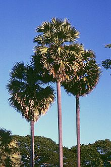
The Lontar palm has high significance in local agriculture
East Nusa Tenggara Province has a diverse economy with agriculture, fisheries, forestry, and cultivation as its main pillars. Subsistence farming dominates economic activity, with corn and smallholder plantation crops such as coffee being the main products. Local plants such as the lontar palm (Borassus flabellifer) and the sugar palm (Arenga pinnata) also play an important role in the local economy.[30]
On Sumba Island, palm trees play a major role in providing wood, roofing materials, and producing food in the form of fruits and palm sugar obtained from tapping the fruit stems. In other areas such as West Manggarai, palm trees are also a source of raw materials and processed products that are useful for local communities. Products from palm and palm trees can even be processed into alcoholic beverages through traditional fermentation, which is part of the local economy.[31]
In addition, the forestry sector also plays an important role in supporting the provincial economy. Forests in East Nusa Tenggara provide important resources such as firewood, building materials, and other non-timber products used by local communities. Forestry managed with sustainable principles not only contributes to the economy, but also helps maintain ecosystems and environmental balance, which is very important for communities that depend on natural resources.
Seaweed farming is one of the fastest growing economic sectors in coastal and island areas. In the Alor Islands, for example, informal village-based seaweed farming has become an important source of additional income for the community. Much of this seaweed is exported in its raw form to countries such as Japan, indicating greater economic potential in this sector.[32]
Fisheries are also a mainstay sector for coastal communities. Marine products such as fish, shrimp, and various other marine products are not only a source of food for local communities but also have great potential as export products. This fisheries activity makes a significant contribution to the local economy.
Overall, the economy of East Nusa Tenggara is highly dependent on the use of natural resources traditionally managed by local communities. With agriculture, fisheries, forestry, and seaweed farming as the backbone of the economy, the province continues to develop its potential while preserving the environment and local cultural richness. Through sustainable management of natural resources, East Nusa Tenggara seeks to improve the welfare of its people and strengthen its contribution to the national economy.
Poverty and Alleviation in East Nusa Tenggara (NTT)
NTT is known as one of the poorest provinces in Indonesia, with various factors causing chronic poverty in this region. The arid geographical conditions and consisting of remote islands make access to basic resources and services difficult. Agriculture, which is the main livelihood, is often hampered by less fertile soil and prolonged drought, resulting in low agricultural productivity. In addition, limited infrastructure worsens people's access to education, health, and markets.[33]
The low level of education in NTT is also one of the main causes of poverty. Limited access to education, especially in rural areas, means that many children cannot continue their education, thus hampering their ability to get better jobs. This is exacerbated by poor health conditions, where many residents cannot access basic health services due to the lack of medical facilities, health workers, and remote access.
The government and various organizations have made a number of efforts to alleviate poverty in NTT. Some of these include the development of infrastructure such as roads, bridges, and health facilities, which aim to open access and improve connectivity throughout the region. Programs to improve the quality of education such as building schools and sending teachers to remote areas are also being implemented to increase school participation rates.[34]
Efforts to empower the community's economy include skills training and access to micro-credit to encourage small and medium enterprises. The tourism sector, which has great potential in NTT, has also begun to be developed as an alternative source of income. In addition, the government has launched social assistance programs such as the Family Hope Program (PKH) and Non-Cash Food Assistance (BPNT) to support poor families in meeting their basic needs.[35]
Although various programs have been implemented, challenges still exist. Corruption, slow bureaucracy, and lack of community involvement in development often hinder the effectiveness of the program. In addition, the impact of climate change on agriculture adds to the complexity of the problem. However, with a sustainable approach and active community participation, there is hope that poverty in NTT can be reduced significantly, bringing prosperity to its residents.[36][37]
Infrastructure
Although infrastructure development in East Nusa Tenggara continues to grow, the province still faces challenges in terms of inter-island connectivity. Land, sea, and air transportation continue to be improved to connect remote areas, but some areas are still difficult to reach, especially during the rainy season when road conditions become less good. On the other hand, the construction of roads, bridges, ports, and airports has been carried out in stages to improve mobility and accessibility, as well as support economic and tourism development in the province.[38]
Education
Education in East Nusa Tenggara continues to improve despite various challenges. Accessibility to education is still difficult, especially in remote areas and islands, where many schools lack basic facilities such as proper buildings, laboratories, and libraries. The quality of teaching also needs to be improved due to the uneven distribution of teachers and the lack of qualified teaching staff in rural areas. Efforts to improve this sector continue to be carried out through government programs such as scholarships and the construction of new schools, although infrastructure and teaching staff challenges remain major issues.[39][40]
Health
The health sector in East Nusa Tenggara sees major challenges in terms of access to and quality of health services. Many remote areas are difficult to reach, and health facilities are often inadequate with limited equipment and medicines. The shortage of medical personnel, especially in rural areas, further exacerbates this situation. Major health problems in NTT (East Nusa Tenggara) include malnutrition, high maternal and infant mortality rates, and infectious diseases such as malaria and tuberculosis. Efforts to improve are being made through the construction of new health facilities, national health programs, and interventions from non-governmental organizations, although geographic and logistical challenges remain major obstacles.[41][42][43]
Tourism
Komodo dragon, a large species of lizard, lives in this province
East Nusa Tenggara is a province rich in diverse and fascinating tourist attractions, and the provincial government is actively working to promote tourism.[44][45] Although the basic infrastructure for the sector, such as transport, accommodation, and information services, still needs strengthening, there are several unique and appealing destinations for visitors to explore:[46]
Komodo Island – Home to the world-famous Komodo dragon.[47]
Kelimutu Volcano – Located on Flores, featuring three striking crater lakes of varying colors.
Mount Mutis – East of Kupang, the province's highest point, popular for hiking and bird-watching.[48]
Semana Santa in Larantuka – A religious tradition celebrated annually.
Sumba Island – Known for traditional housing and the Pasola festival.[49]
Alor Island – A renowned diving destination with rich marine biodiversity.
Nemberalla Beach – Situated in Rote Ndao, popular for its pristine waters and surfing.
Pink Beach – Located on Padar Island, famous for its unique pink sand.
17 islands National Park – On Riung Island, known for its natural beauty and tranquility.
Many local community groups continue to strive to further develop and promote the tourism industry.[50] However, more support and investment are needed to fully unlock the province's tourism potential and ensure that these destinations reach a wider audience. With enhanced infrastructure and sustained promotion, East Nusa Tenggara has the potential to become one of Indonesia's premier tourist hotspots.[51]
Well-known figures
Well-known figures from the province include the following:
↑ excluding population of Malaka Regency (created 2012)
↑ Law No. 7/2017 (UU No. 7 Tahun 2017) as amended by Government Regulation in Lieu of Law No. 1/2022 and Regulation of General Elections Commission No. 6/2023.
↑ Abidin, Zainal, et al. "Poverty Alleviation Through Village Fund Policy in East Nusa Tenggara." Proceedings of the 1st International Conference on Social Sciences, Humanities, Economics, and Law (ICoSHEL), 30 Oct. 2019, European Union Digital Library, doi:10.4108/eai.30-10-2019.2299419. Accessed 2024-08-30.
↑ Nalle, F. W., Seran, S., & Bria, F. (2022). Analisis Determinan Kemiskinan Propinsi Nusa Tenggara Timur. Jurnal Samudra Ekonomi Dan Bisnis, 13(2), 206-220. https://doi.org/10.33059/jseb.v13i2.4962
↑ Celebrating its 75th anniversary, WHO calls for health for all from East Nusa Tenggara
↑ A useful guide to NTT which is in Indonesian but which, nevertheless, has much accessible information and maps about NTT is by Gagas Ulung (2011), Exotic NTT: 200 tempat paling menantang dan eksotis di provinsi Nusa Tenggara Timur: wisata alam, bahari, budaya, dan tradisi [Exotic NTT: 200 of the most challenging and exotic places in Nusa Tenggara Timur: tourism for nature, the sea, culture, and tradition], PT Gramedia Pustaka Utama, Jakarta.
↑ Tim Gudang Ilmu (2011), Pahlawan Indonesia & profilnya: edisi terlengkap [Profiles of heroes of Indonesia; a complete edition], Gudang Ilmu, Jakarta.
The NTT website of the Indonesian Central Statistics Bureau (Badan Pusat Statistik or BPS) which provides data on a range of matters in the province. Especially helpful is the annual publication NTT dalam Angka [NTT in Figures] which provides very extensive statistics about a wide range of issues.
This page is based on this Wikipedia article Text is available under the CC BY-SA 4.0 license; additional terms may apply. Images, videos and audio are available under their respective licenses.