Kupang Regency

Last updated
Kupang Regency
Kabupaten Kupang
Lambang Kabupaten Kupang.png
Lokasi Nusa Tenggara Timur Kabupaten Kupang.svg
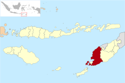
Location within East Nusa Tenggara
Timor.png
Red pog.svg
Kupang Regency
Indonesia Lesser Sunda Islands location map.svg
Red pog.svg
Kupang Regency
Kupang Regency (Lesser Sunda Islands)
Indonesia location map.svg
Red pog.svg
Kupang Regency
Kupang Regency (Indonesia)
Coordinates: 10°18′S123°43′E / 10.300°S 123.717°E / -10.300; 123.717 Coordinates: 10°18′S123°43′E / 10.300°S 123.717°E / -10.300; 123.717
Country Flag of Indonesia.svg  Indonesia
Region Lesser Sunda Islands
Province Flag of East Nusa Tenggara.svg  East Nusa Tenggara
Capital Oelamasi  [ id ]
Government
  RegentKorinus Masneno
  Vice RegentJerry Manafe
Area
  Total2,045.62 sq mi (5,298.13 km2)
Population
 (mid 2022 estimate)
  Total379,464
  Density190/sq mi (72/km2)
  [1]
Time zone UTC+8 (ICST)
Area code (+62) 380
Website

Kupang Regency is a regency in East Nusa Tenggara province of Indonesia. It occupies the far western end of Timor Island (apart from the area of Kupang city, which has been administratively separated from the Regency since 11 April 1996), together with the small offshore island of Semau (off the western tip of Timor). Other islands to the southwest and west which were formerly part of Kupang Regency have been separated administratively - the Rote Islands Group on 10 April 2002 (to form Rote Ndao Regency), and the Savu Islands on 29 October 2008 (to form Sabu Raijua Regency). The capital of Kupang Regency is at Oelamasi. [2]

Contents

Administration

The regency is divided into twenty-four districts (kecamatan), tabulated below with their areas and their populations at the 2010 Census [3] and the 2020 Census, [4] together with the official estimates as at mid 2022. [5] The table also includes the locations of the district administrative centres, the number of villages (rural desa / urban kelurahan) in each district, and its post code.

NameEnglish nameArea
in
km2
Population
Census
2010
Population
Census
2020
Population
Estimate
mid 2022
Admin
centre
No.
of
desa /
kelurahan
Post
code
SemauSemau Island (North)143.426,6887,6147,798Uitao8 / -85352
Semau SelatanSemau Island (South)153.004,7315,3965,528Akle6 / -85353
Totals Semau IslandSemau Island296.4211,41913,01013,32614 / -
Kupang BaratWest Kupang149.7215,41718,27018,858Batakte10 / 285351
Nekamese128.409,01011,52412,072Oemasi11 / -85390
Kupang TengahCentral Kupang88.6433,80545,70948,400Tarus7 / 185361
Taebenu106.4214,59418,16618,930Baumata8 / -85360
Amarasi154.9015,27917,88118,411Oekabiti8 / 185367
Amarasi BaratWest Amarasi246.4714,37516,84617,062Teunbaun7 / 185376
Amarasi SelatanSouth Amarasi172.7110,27611,83912,153Buraen3 / 285377
Amarasi TimurEast Amarasi162.927,0548,9359,342Pakubaun4 / -85378
Kupang TimurEast Kupang338.6040,52551,03253,297Babau8 / 585362
Amabi Oefeto TimurEast Amabi Oefeto236.7213,05913,27713,304Oemofa10 / -85363
Amabi OefetoAmabi Oefeto123.907,7478,6118,778Fatuknutu7 / -85362
& 85363
Sulamu141.1814,28017,39418,049Sulamu6 / 185368
Fatuleu351.5223,00726,84927,631Camplong9 / 185371
Fatuleu BaratWest Fatuleu496.478,3999,0709,195Poto5 / -85323
Fatuleu TengahCentral Fatuleu107.854,8855,7365,910Oelbiteno4 / -85320
Takari508.1320,26224,56625,469Takari9 / 185369
Amfoang SelatanSouth Amfoang305.098,62810,00310,281Lelogama6 / 185373
Amfoang Barat DayaSouthwest Amfoang167.614,2635,0755,243Manubelon4 / -85364
Amfoang UtaraNorth Amfoang428.597,0048,0918,310Soliu5 / 185365
Amfoang Barat LautNorthwest Amfoang133.248,76210,37610,708Nunuanah6 / -85372
Amfoang TimurEast Amfoang174.217,1017,7137,828Fatumonas5 / -85375
Amfoang TengahCentral Amfoang278,425,3976,4106,619Naikliu4 / -85374
Totals5,298.13304,548366,383379,464Oelamasi160 / 17

Related Research Articles

<span class="mw-page-title-main">East Nusa Tenggara</span> Province of Indonesia

East Nusa Tenggara is the southernmost province of Indonesia. It comprises the eastern portion of the Lesser Sunda Islands, facing the Indian Ocean in the south and the Flores Sea in the north. It consists of more than 500 islands, with the largest ones being Sumba, Flores, and the western part of Timor; the latter shares a land border with the separate nation of East Timor. The province is subdivided into twenty-one regencies and the regency-level city of Kupang, which is the capital and largest city.

<span class="mw-page-title-main">West Nusa Tenggara</span> Province of Indonesia

West Nusa Tenggara is a province of Indonesia. It comprises the western portion of the Lesser Sunda Islands, with the exception of Bali which is its own province. Mataram, on Lombok, is the capital and largest city of the province. The 2010 census recorded the population at 4,500,212; the total rose to 4,830,118 at the 2015 census and 5,320,092 at the 2020 census; the official estimate as at mid 2022 was 5,473,671. The province's area is 20,153.15 km2. The two largest islands by far in the province are Lombok in the west and the larger Sumbawa island in the east.

<span class="mw-page-title-main">Sikka Regency</span> Regency in Lesser Sunda Islands, Indonesia

Sikka is a regency within East Nusa Tenggara province, Indonesia, on the island of Flores. It covers an area of 1,731.91 km2 and had a population of 300,301 at the 2010 census and 321,953 at the 2020 Census; the official estimate as at mid 2022 was 326,999. The capital is the town of Maumere, which comprises the districts of Alok Barat, Alok and Alok Timur.

<span class="mw-page-title-main">Ende Regency</span> Regency in East Nusa Tenggara, Indonesia

Ende Regency is a regency on the island of Flores, within East Nusa Tenggara Province of Indonesia. The capital is the town of Ende. The regency covers an area of 2,085.19 km2, and it had a population of 260,605 at the 2010 Census and 270,763 at the 2020 Census; the official estimate as at mid 2022 was 273,553.

<span class="mw-page-title-main">West Sumba Regency</span> Regency in Lesser Sunda Islands, Indonesia

West Sumba Regency is a regency in East Nusa Tenggara Province of Indonesia. Established in 1958, the regency was considerably reduced in 2007 with the creation of new Regencies on Sumba Island. Its area is now 737.42 km2, and its population was 111,993 at the 2010 census and 145,097 at the 2020 Census; the official estimate as at mid 2022 was 152,407. It has its seat (capital) in (Kota) Waikabubak.

<span class="mw-page-title-main">Alor Regency</span> Regency in Indonesia

Alor Regency is a regency (kabupaten) in East Nusa Tenggara (NTT) province of Indonesia. Established in 1958, Alor Regency administers the Alor Archipelago with its seat (capital) in Kalabahi on Alor Island.

<span class="mw-page-title-main">Belu Regency</span> Regency in Lesser Sunda Islands, Indonesia

Belu Regency is a regency in East Nusa Tenggara province of Indonesia. Established on 20 December 1958, Belu Regency has its seat (capital) in the large town of Atambua.

<span class="mw-page-title-main">Central Sumba Regency</span> Regency in Lesser Sunda Islands, Indonesia

Central Sumba Regency is a regency in East Nusa Tenggara of Indonesia. The new Central Sumba Regency was established on the island of Sumba when West Sumba Regency was split into two regencies on 22 May 2007 and a further Regency was created in Central Sumba from parts of both West Sumba and East Sumba Regencies. The new Regency covers 2,060.54 km2 and had a population of 62,485 at the 2010 Census and 85,482 at the 2020 Census; the official estimate as at mid 2022 was 90,482. The seat (capital) of its government is located at Waibakul.

<span class="mw-page-title-main">East Sumba Regency</span> Regency in Lesser Sunda Islands, Indonesia

East Sumba Regency is geographically the largest of the four regencies which divide the island of Sumba, within East Nusa Tenggara Province of Indonesia. It occupies 64% of the entire island, being much less densely populated than the western third. The town of Waingapu is the capital of East Sumba Regency. The population of East Sumba Regency was 227,732 at the 2010 Census and 244,820 at the 2020 Census, comprising 125,967 male and 118,853 female; the official estimate as at mid 2022 was 248,776.

<span class="mw-page-title-main">West Manggarai Regency</span> Regency in Indonesia

West Manggarai Regency is one of the eight regencies which comprise the island of Flores, located in the province of East Nusa Tenggara in Indonesia. The Regency was created on 25 February 2003 by separation off the western districts of Manggarai Regency. It covers a land area of 3,141.47 km2, and had a population of 221,703 at the 2010 census, rising to 251,689 at the 2015 Intermediate census and to 256,317 at the 2020 census. The official estimate as at mid 2022 was 263,687. The regency's capital is the town of Labuan Bajo.

<span class="mw-page-title-main">Bima Regency</span> Regency in West Nusa Tenggara, Indonesia

Bima Regency is a regency of the Indonesian Province of West Nusa Tenggara. It is located on the island of Sumbawa and the capital is Woha. The Regency covers an area of 4,389.40 km2, and had a population of 438,522 at the 2010 Census and 514,105 at the 2020 Census; the official estimate as at mid 2021 was 520,444. It administratively excludes but geographically completely surrounds Bima City on the landward side.

<span class="mw-page-title-main">East Lombok Regency</span> Regency in West Nusa Tenggara, Indonesia

East Lombok Regency is a regency of the Indonesian Province of West Nusa Tenggara. It is located on the island of Lombok, of which it comprises the eastern third ; the administrative capital is the town of Selong. The Regency covers an area of 1,605.55 km2 and had a population of 1,105,582 at the 2010 Census and 1,325,240 at the 2020 Census; the official estimate as at mid 2021 was 1,343,901.

<span class="mw-page-title-main">Dompu Regency</span> Regency in West Nusa Tenggara, Indonesia

Dompu Regency is a regency of the Indonesian Province of West Nusa Tenggara. It is located on the island of Sumbawa and the capital is Dompu. It is bordered to the north and to the east by two non-contiguous parts of Bima Regency, and to the west by Sumbawa Regency, as well as on its coasts by Saleh Bay, Sanggar Bay, and Cempi Bay. It covers an area of 2,324.55 km2, and the population at the 2010 Census was 218,984 and at the 2020 Census was 236,665; the official estimate as at mid 2021 was 238,201.

<span class="mw-page-title-main">East Flores Regency</span> Regency in East Nusa Tenggara, Indonesia

East Flores Regency is a regency in East Nusa Tenggara province of Indonesia. Established in 1958, the regency has its seat (capital) in Larantuka on Flores Island. It covers a land area of 1,812.85 km2, and it had a population of 232,605 as of the 2010 census and 276,896 at the 2020 Census; the official estimate as at mid 2022 was 288,897. The regency encompasses the eastern tip of the island of Flores, together with all of the adjacent islands of Adonara and Solor to the east of Flores, with some much smaller offshore islands. In 1999 the island of Lembata at the eastern end of the Solor Archipelago was separated out to create its own Regency.

<span class="mw-page-title-main">Manggarai Regency</span> Regency in East Nusa Tenggara, Indonesia

Manggarai Regency is a regency in East Nusa Tenggara province of Indonesia, situated on the island of Flores. Established in 1958 the regency was reduced in size and population by the separation of Manggarai Barat regency in 2003 and of Manggarai Timur regency in 2007. The area of the residual Manggarai Regency is 1,344.03 km2 and its population was 292,037 at the 2010 census and 312,855 at the 2020 census; the official estimate as at mid 2022 was 317,646. The capital of the regency is the town of Ruteng.

<span class="mw-page-title-main">South Central Timor Regency</span> Regency in Lesser Sunda Islands, Indonesia

South Central Timor Regency is a regency in East Nusa Tenggara province of Indonesia. Established in 1958, the regency has its seat (capital) in the town of Soe. It covers an area of 3,955.36 km2 and had a population of 440,470 at the 2010 Census and 455,410 at the 2020 Census; the official estimate as at mid 2021 was 457,958.

<span class="mw-page-title-main">North Central Timor Regency</span> Regency of Indonesia

North Central Timor Regency is a regency in East Nusa Tenggara Province, Indonesia. It covers an area of 2,669.70 km2, and had a population of 229,803 at the 2010 Census and 259,829 at the 2020 Census; the official estimate as at mid 2021 was 262,598. Its regency seat is located at the town of Kefamenanu, which had a population of 48,202 in mid 2021. The regency borders Timor Leste's Oecusse enclave, one of few Indonesian regions that have a land border with other countries.

<span class="mw-page-title-main">Lembata Regency</span> Regency in East Nusa Tenggara, Indonesia

Lembata Regency is a regency in East Nusa Tenggara province of Indonesia. Established on 4 October 1999 from part of East Flores Regency, the regency covers the island of Lembata, together with three small offshore islands together forming the eastern part of the Solor Archipelago, and has its administrative seat (capital) in Lewoleba. The population of the Regency was 117,829 at the 2010 decennial census and at the 2020 census was 135,930; the official estimate as at mid 2022 was 139,787.

<span class="mw-page-title-main">Rote Ndao Regency</span> Southernmost Regency in Indonesia

Rote Ndao Regency is a regency in East Nusa Tenggara province of Indonesia, consisting primarily of the island of Rote, situated south-west of the western tip of West Timor with an area of 978.54 km2, together with minor offshore islands including Usu, Ndana, Ndao, Landu and Nuse; the total area including the minor offshore islands is 1,280.10 km2. The regency seat is in the village of Ba'a, which is situated in Lobalain District. The population of the Regency was 119,908 as of the 2010 census and 143,764 at the 2020 Census; the official estimate as at mid 2022 was 148,811.

<span class="mw-page-title-main">Sabu Raijua Regency</span> Regency in Lesser Sunda Islands, Indonesia

Sabu Raijua Regency is one of the regencies in the province of East Nusa Tenggara, Indonesia. It comprises the three Savu Islands, lying between Sumba and Rote Island in the Savu Sea. The regency was established by Indonesia's Minister of Home Affairs, Mardiyanto, on 29 October 2008, partitioned from Kupang Regency. The population was 72,960 at the 2010 census, and 89,327 at the 2020 Census; the official estimate as at mid 2021 was 90,837.

References

  1. Badan Pusat Statistik, Jakarta, 2023.
  2. Government of Indonesia (9 August 1958), Establishment of the Second-level Administrative Regions under the First-level Administrative Region of Bali, West Nusa Tenggara and East Nusa Tenggara (in Indonesian), Indonesia Ministry of Law and Justice, UU No. 69/1958
  3. Population by Region, Urban/Rural, and Sex: Kupang Regency
  4. Jumlah Penduduk Menurut Jenis Kelamin (Jiwa), 2018-2020
  5. Badan Pusat Statistik, Jakarta, 2023.