Rote Ndao Regency

Last updated
Rote Ndao Regency
Kabupaten Rote Ndao
Baa Rote Ndao.jpg
Ba'a, regency seat of Rote Ndao from above
Lambang Kabupaten Rote Ndao.png
Lokasi Nusa Tenggara Timur Kabupaten Rote Ndao.svg
Location within East Nusa Tenggara
Indonesia Lesser Sunda Islands location map.svg
Red pog.svg
Rote Ndao Regency
Indonesia location map.svg
Red pog.svg
Rote Ndao Regency
Rote Ndao Regency (Indonesia)
Coordinates: 10°28′00″S123°23′00″E / 10.4667°S 123.3833°E / -10.4667; 123.3833
Country Flag of Indonesia.svg  Indonesia
Region Lesser Sunda Islands
Province Flag of East Nusa Tenggara.svg  East Nusa Tenggara
Capital Baa
Government
  RegentLeonard Haning
  Vice RegentJonas. C. Lun
Area
  Land494.25 sq mi (1,280.10 km2)
Population
 (mid 2022 estimate) [1]
  Total148,811
Area code (+62) 380
HDI (2020)Increase2.svg 0.627 (Medium) [2]
Website rotendaokab.go.id

Rote Ndao Regency is a regency in East Nusa Tenggara province of Indonesia, consisting primarily of the island of Rote, situated south-west of the western tip of West Timor with an area of 978.54 km2, together with minor offshore islands including Usu (19.4 km2), Ndana (13.83 km2), Ndao, Landu and Nuse; the total area including the minor offshore islands is 1,280.10 km2. The regency seat is in the village of Ba'a (or Baadale), which is situated in Lobalain District. The population of the Regency was 119,908 as of the 2010 census [3] and 143,764 at the 2020 Census; [4] the official estimate as at mid 2022 was 148,811. [1]

Contents

History

Established in 2002 under Law (Undang-Undang) RI No.9 dated 10 April 2002, it was previously a part of Kupang Regency. [5]

In 1962, it was divided into 4 districts; West, East, South, and Central Rote. Later, in 1967 it was split into 8 districts to fulfill requirements to become an independent regency. This goal was finally realized in 2002 after central government was pressurised by around 300 cultural figures from 19 traditional regions in the area. [5]

Infrastructure

There are 542,5 kilometres of road in the regency, from which 314,7 kilometres have been paved with asphalt as of 2020. [6] The regency is served by David Constantijn Saudale Airport with 1200 metres of a single runway, located around 7 kilometres from the regency seat. [7]

There are four ports in the regency, the biggest and busiest being Ba'a Port, which handled 55% of the region's ship traffic in 2019. [6] Ba'a Port is also connected to president Joko Widodo's sea toll program route TL13 which aimed to reduce development and economic gap between isolated regions. [8] [9] Government of Indonesia also constructed a laboratorium and quarantine facility in the port in 2019 as part of massive expansions of the port. [9]

The regency has one regional hospital owned by government of the regency, in addition to 12 puskesmas, 381 healthcare centers, 14 maternity cottages, and four pharmacies. [7] The regional hospital, Ba'a Regional Hospital is located on regency seat. It is classified as D class hospital by Indonesian Ministry of Health. [10] Education facilities in the regency consist of 65 kindergartens, 145 elementary schools, 53 junior highschools, 10 senior highschools, 5 vocational highschools, and one special education school. There's also one higher education institution, Nusa Lontar Rote University. [7] [11]

There are exactly 456 Protestant churches, 13 Catholic churches, 11 mosques, and one Hindu temple. [6] [7] As of 2020, most of the regency has access to 4G internet services and other telecommunication services. [12] The only fiber optic service provider in the regency is IndiHome, which is state-owned under Telkomsel. [13]

Economy

Main economic activities in the region as of 2019 was agriculture. [6] There are 22,684 ha of paddy fields in the regency. 50.36% of the regency's workforce work on agriculture sector and contributes to 47.12% of regency's economy. Another important commodity is red onion, which the regency produced 34,257 quintals of it in 2019. Other commodities such as coconut and guava also exist, which the regency's produced 3,445 tons and 45 tons in order. [6] Mining and energy sector contributes around 12% to regency's economy as of 2019. Food processing industry also have established presence in the region and employed around 5,000 workers as of 2019. [6]

Tourism is a small but growing sector in the regency. [6] There were 21 homestays and 33 hotels in varying quality of service on the regency as of 2019. [6] In the same year, the regency was visited by exactly 4,988 tourists, whom more than half of it came from abroad. This was an increase from 2018, which the regency saw 3,861 tourists visiting the region. [6]

Economic growth was 5.23% in 2019, a slight decrease from previous year with 5.42%. The fastest growing sector was natural gas and energy with increase of 18% on the same year. [6] [14] At the same time, unemployment rate was 2.03%. [14]

Geography

The regency is surrounded by water, bordering the Savu Sea to the north, the Indian Ocean to the south and west, and the Pukuafu Strait to the east. It is composed of 107 islands, 8 of which are inhabited and 99 are uninhabited. [5] The topography varies from flat make up 35% of its territory to hills around 25%, from 0 to 1,500 meters above sea level. Around 60% of its territory are 200 meters above sea level. [5]

Administration

This Regency was originally composed of six districts (kecamatan), but it later underwent re-organisation into eight districts, and in 2012 into ten districts; an eleventh district (Loaholu) has subsequently been added from the western part of Rote Barat Laut District. Their areas (in km2) and their 2010 [3] and 2020 Census populations are listed below, [4] together with the official estimates as at mid 2022. [1] The table also includes the locations of the district administrative centres, the number of administrative villages in each district (in total, 112 rural desa and 7 urban kelurahan), and its postal codes.

Kode
Wilayah
Name of
District
(kecamatan)
English
name
Area
in
km2
Pop'n
Census
2010
Pop'n
Census
2020
Pop'n
Estimate
mid 2022
Admin
centre
No.
of
villages
Post
codes
53.14.01Rote Barat Daya (a)Southwest
Rote Island
114.5719,73724,30925,276Batutua1985982
53.14.02Rote Barat Laut (b)Northwest
Rote Island
98.5322,60826,91616,117Busalangga12 (c)85981
53.14.11Loaholu73.87(d)(d)11,750Oelaba1085981
53.14.03Lobalain(Busalangga)145.7024,78930,66931,891Ba'a18 (e)85912
- 85918
53.14.04Rote TengahMiddle Rote162.508,0588,9849,173Feapopi8 (c)85971
53.14.08Rote SelatanSouth Rote73.385,1736,0156,188Daleholu785972
53.14.05Pantai BaruBaru Beach176.1812,39714,47614,920Olafulihaa15 (c)85973
53.14.06Rote Timur (f)East Rote110.8412,09314,34314,785Eahun11 (c)85975
53.14.10 Landu Leko 194.064,5405,2475,409Landu Leko785974
53.14.07Rote BaratWest Rote116.287,4269,1139,467Delha785981
& 85982
53.14.09Ndao Nuse (g)14.193,0873,6923,835Ndao Nuse585983
Totals1,280.10119,908143,764148,811Ba'a119

Notes: (a) including 36 offshore islands. (b) including 7 offshore islands. (c) including one kelurahan.
(d) the 2010 and 2020 Census populations of the new Loaholu District are included in the figures for Rote Barat Laut District, from which it was cut out. (e) comprises 3 kelurahan and 15 desa. (f) including 45 offshore islands.
(g) Ndao Nuse District comprises the offshore Ndao Island (with an area of 8.63 km2), Nuse Island (5.66 km2) and Do'o Island.

Related Research Articles

<span class="mw-page-title-main">Rote Island</span> Southernmost Island in Indonesia

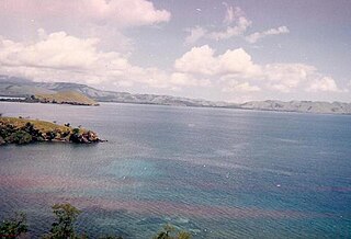
Rote Island is an island of Indonesia, part of the East Nusa Tenggara province of the Lesser Sunda Islands. According to legend, this island got its name accidentally when a lost Portuguese sailor arrived and asked a farmer where he was. The surprised farmer, who could not speak Portuguese, introduced himself, "Rote".

<span class="mw-page-title-main">Sikka Regency</span> Regency in Lesser Sunda Islands, Indonesia

Sikka is a regency within East Nusa Tenggara province, Indonesia, on the island of Flores. It is bordered to the west by Ende Regency and to the east by East Flores Regency. It covers an area of 1,731.91 km2 and had a population of 300,301 at the 2010 census and 321,953 at the 2020 Census; the official estimate as at mid 2022 was 326,999. The capital is the town of Maumere, which comprises the districts of Alok Barat, Alok and Alok Timur.

<span class="mw-page-title-main">Bulungan Regency</span> Regency in North Kalimantan, Indonesia

Bulungan Regency is a regency of North Kalimantan Province in Indonesia. It covers an area of 13,181.92 km2 and had a population of 112,663 at the 2010 Census and 151,844 at the 2020 Census; the official estimate as at mid 2022 was 157,593. The administrative centre is at Tanjung Selor.

<span class="mw-page-title-main">Jember Regency</span> Regency of Indonesia

Jember Regency is a regency of East Java province, Indonesia. The land area is 3,306.69 km2, and the population was 2,332,726 at the 2010 census and 2,536,729 at the 2020 Census; the official estimate as at mid 2022 was 2,584,233. Its administrative capital is the urban area of Jember, which with 360,568 inhabitants in mid 2022 is the third largest urban area in East Java province but does not have municipality or city status as it is split between three separate administrative districts (kecamatan). Jember is famous for its tobacco farms and traditional food called tape which is made of fermented cassava.

<span class="mw-page-title-main">Tanah Bumbu Regency</span> Regency in South Kalimantan, Indonesia

Tanah Bumbu is one of the regencies in the Indonesian province of South Kalimantan. It was formerly part of Kotabaru Regency, but was split off on 25 February 2003 to form a separate regency, following dissatisfaction on the Kalimantan mainland territories with administration from Laut Island. It covers an area of 4,890.3 km2 and had a population of 267,929 at the 2010 Census and 322,646 at the 2020 Census; the latest official estimate is 335,079. The regency's capital is the town of Batulicin.

<span class="mw-page-title-main">Selayar Islands Regency</span> Regency in Sulawesi, Indonesia

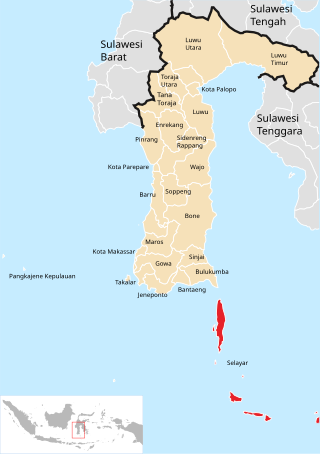
The Selayar Islands Regency is a regency of Indonesia in South Sulawesi province that covers the Selayar Islands, which lie southeast of the southern peninsula of Sulawesi. The archipelago consists of the group's main island, which is surrounded by 41 smaller islands around its coast; further to the southeast lies a widespread group of islands, including the huge atoll of Takabonerate. The regency covers an area of 1,357.03 km2, and had a population of 103,596 at the 2000 Census, 122,055 at the Census of 2010 and 137,071 at that of 2020. The official estimate for mid 2022 was 139,145. The administrative centre is the town of Benteng on Selayar Island. The Selayar Straits separate the regency from Sulawesi island.

<span class="mw-page-title-main">West Sumba Regency</span> Regency in Lesser Sunda Islands, Indonesia

West Sumba Regency is a regency in East Nusa Tenggara Province of Indonesia. Established in 1958, the regency was considerably reduced on 22 May 2007 with the creation of new Regencies on Sumba Island under Law UU No.16 of that year. Its area is now 737.42 km2, and its population was 110,993 at the 2010 census and 145,097 at the 2020 Census; the official estimate as at mid 2022 was 152,407. It has its seat (capital) in (Kota) Waikabubak.

<span class="mw-page-title-main">Belu Regency</span> Regency in Lesser Sunda Islands, Indonesia

Belu Regency is a regency in East Nusa Tenggara province of Indonesia. Situated on the north of Timor island, it adjoins the separate nation of East Timor to the east. Established on 20 December 1958, Belu Regency has its seat (capital) in the large town of Atambua.

<span class="mw-page-title-main">Batubara Regency</span> Regency in North Sumatra, Indonesia

Batubara Regency is a regency on North Sumatra's eastern shoreline, with Limapuluh as its seat. It was carved out from the seven most westerly coastal districts of Asahan Regency with effect from 15 June 2007. The new regency covers an area of 885.89 km2, and had a population of 375,885 at the 2010 Census and 410,678 at the 2020 Census, of whom 206,551 were male and 204,127 were female; the official estimate as at mid 2022 was 416,367.

<span class="mw-page-title-main">East Sumba Regency</span> Regency in Lesser Sunda Islands, Indonesia

East Sumba Regency is geographically the largest of the four regencies which divide the island of Sumba, within East Nusa Tenggara Province of Indonesia. It occupies 64% of the entire island, being much less densely populated than the western third. The town of Waingapu is the capital of East Sumba Regency. The population of East Sumba Regency was 227,732 at the 2010 Census and 244,820 at the 2020 Census, comprising 125,967 male and 118,853 female; the official estimate as at mid 2022 was 248,776.

<span class="mw-page-title-main">Dompu Regency</span> Regency in West Nusa Tenggara, Indonesia

Dompu Regency is a regency of the Indonesian Province of West Nusa Tenggara. It is located on the island of Sumbawa and the capital is Dompu. It is bordered to the north and to the east by two non-contiguous parts of Bima Regency, and to the west by Sumbawa Regency, as well as on its coasts by Saleh Bay, Sanggar Bay, and Cempi Bay. It covers an area of 2,324.55 km2, and the population at the 2010 Census was 218,984 and at the 2020 Census was 236,665; the official estimate as at mid 2022 was 239,781.

<span class="mw-page-title-main">East Flores Regency</span> Regency in East Nusa Tenggara, Indonesia

East Flores Regency is a regency in East Nusa Tenggara province of Indonesia. Established in 1958, the regency has its seat (capital) in Larantuka on Flores Island. It covers a land area of 1,812.85 km2, and it had a population of 232,605 as of the 2010 census and 276,896 at the 2020 Census; the official estimate as at mid 2022 was 288,897. The regency encompasses the eastern tip of the island of Flores, together with all of the adjacent islands of Adonara and Solor to the east of Flores, with some much smaller offshore islands. On 4 October 1999 the island of Lembata at the eastern end of the Solor Archipelago was separated out from the East Flores Regency to create its own Regency.

<span class="mw-page-title-main">Kupang Regency</span> Regency in Lesser Sunda Islands, Indonesia

Kupang Regency is a regency in East Nusa Tenggara province of Indonesia. It occupies the far western end of Timor Island, together with the small offshore island of Semau. Other islands to the southwest and west which were formerly part of Kupang Regency have been separated administratively - the Rote Islands Group on 10 April 2002, and the Savu Islands on 29 October 2008. The capital of Kupang Regency is at Oelamasi.

<span class="mw-page-title-main">Sabu Raijua Regency</span> Regency in Lesser Sunda Islands, Indonesia

Sabu Raijua Regency is one of the regencies in the province of East Nusa Tenggara, Indonesia. It comprises the three Savu Islands, lying between Sumba and Rote Island in the Savu Sea, with a land area of 459.58 km2. The regency was established by Indonesia's Minister of Home Affairs, Mardiyanto, on 29 October 2008, when it was partitioned from Kupang Regency. The population was 72,960 at the 2010 census, and 89,327 at the 2020 Census; the official estimate as at mid 2022 was 92,792.

<span class="mw-page-title-main">North Penajam Paser Regency</span> Regency in East Kalimantan, Indonesia

North Penajam Paser Regency is a regency in the Indonesian province of East Kalimantan. Its administrative centre is the town of Penajam. The area which now forms North Penajam Paser was part of Paser Regency until its creation as a separate regency on 10 April 2002. It covers an area of 3,333.06 km2 and it had 142,922 inhabitants at the 2010 census and 178,681 at the 2020 census; the official estimate as at mid 2022 was 183,043. North Penajam Paser Regency has the smallest area among the seven regencies in East Kalimantan province.

<span class="mw-page-title-main">Buton Regency</span> Regency in Southeast Sulawesi, Indonesia

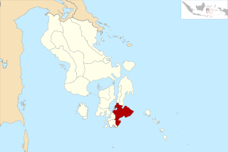
Buton Regency is a regency of Indonesia's Southeast Sulawesi Province, lying entirely on Buton Island. Until 2014 it had an area of 2,681.22 km2, and a population estimated at 276,944. However, in 2014 it was divided into three regencies, with two new regencies being cut out of it; the residual area now is 1,648.04 km2, and the districts in that area contained a population of 94,388 at the 2010 Census while the 2020 Census produced a total of 115,207; the official estimate as at mid 2022 was 119,353.

<span class="mw-page-title-main">Sangihe Islands Regency</span> Regency of Indonesia

The Sangihe Islands Regency is a regency of North Sulawesi Province, Indonesia. It comprises a group of islands situated to the North of Sulawesi. It covers a land area of 736.98 km2, and had a population of 126,100 at the 2010 census and 139,262 at the 2020 census; the official estimate as at mid 2022 was 140,165. The principal island is also named Sangihe, on which lies the main town of Tahuna. Minor island groups within the Regency include the Marore group considerably to the north of Sangihe Island, the Tatoareng group to the south, and the Nusa Tabukan group off the northeast coast of Sangihe Island. It borders the Philippines in the north, making it one of Indonesia's border regions.

<span class="mw-page-title-main">South Minahasa Regency</span> Regency in North Sulawesi, Indonesia

South Minahasa Regency is a regency in North Sulawesi, Indonesia. Its capital is the town of Amurang. It was originally part of the Minahasa Regency until it was established as a separate regency on 25 February 2003. In turn, a Southeast Minahasa Regency was established as a separate regency from part of the South Minahasa Regency on 2 January 2007. The residual Regency now covers an area of 1,456.46 km2, and had a population of 195,553 at the 2010 Census; this had risen to 236,463 at the 2020 Census; the official estimate as at mid 2022 was 241,680.

<span class="mw-page-title-main">Banggai Sea Regency</span> Regency in Central Sulawesi, Indonesia

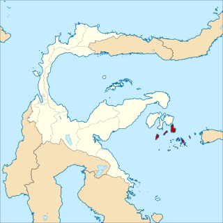
Banggai Sea Regency is a regency in the province of Central Sulawesi, Indonesia. The regency was established on 14 December 2012, partitioned from the Banggai Islands Regency. It comprises southern part of the Banggai Islands archipelago, including the main island of Banggai itself, the islands of Labobo and Bangkurung to the southwest of Banggai Island, and the numerous small Bokan Islands to the southeast. It covers a land area of 725.67 km2, and the districts now comprising the new Regency had a population of 62,183 at the 2010 Census and 70,435 at the 2020 Census; the official estimate as at mid 2022 was 71,350.

<span class="mw-page-title-main">Ba'a</span> Place in East Nusa Tenggara, Indonesia

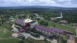
Ba'a is the capital of the Indonesian island of Rote and of the Rote Ndao Regency (kabupaten), in the province of East Nusa Tenggara. It lies in the district (kecamatan) of Lobalain, and constitutes a village (desa) with 1,263 inhabitants at the 2020 Census.

References

  1. 1 2 3 Badan Pusat Statistik, Jakarta, 2023, Kabupaten Rote Ndao Dalam Angka 2023 (Katalog-BPS 1102001.5314)
  2. "Ekonomi". Rote Ndao. Retrieved 2021-04-12.
  3. 1 2 Biro Pusat Statistik, Jakarta, 2011.
  4. 1 2 Badan Pusat Statistik, Jakarta, 2021.
  5. 1 2 3 4 "Profil Daerah | Rote Ndao" . Retrieved 2021-04-12.
  6. 1 2 3 4 5 6 7 8 9 10 "Kabupaten Rote Ndao Dalam Angka 2020" [Rote Ndao Regency Figures 2020](PDF). rotendaokab.bps.go.id (in Indonesian). Retrieved 2021-04-12.
  7. 1 2 3 4 "Fasilitas | Rote Ndao" . Retrieved 2021-04-12.
  8. "Pengadaan.id | Pelabuhan Ba'a Rote Sebagai Bagian Tol Laut Masih Perlu Ditingkatkan Lagi". www.pengadaan.id. Retrieved 2021-04-12.
  9. 1 2 "Pelabuhan Ba'a Terus Berbenah | RoteOnline News • Media" (in Indonesian). 2019-11-19. Retrieved 2021-04-12.
  10. "Informasi SDM Kesehatan Nasional". bppsdmk.kemkes.go.id. Retrieved 2021-04-12.
  11. "Universitas Nusa Lontar Rote". www.unstarrote.ac.id. Retrieved 2021-04-12.
  12. "Tak Perlu ke Pesisir Pantai, Kini Warga Desa Ndao Dapat Menikmati Jaringan Kuat Telkomsel Dari Rumah". Bali Tribune. 2020-11-14. Retrieved 2021-04-12.
  13. "IndiHome Kini Hadir di Pulau Rote". Republika Online (in Indonesian). 2019-09-19. Retrieved 2021-04-12.
  14. 1 2 "Ekonomi | Rote Ndao" . Retrieved 2021-04-12.

Notes