Belu Regency

Last updated

Belu Regency
Kabupaten Belu
Rai Belu
Lambang Kabupaten Belu.jpg
Nickname: 
Belu
Lokasi Nusa Tenggara Timur Kabupaten Belu.svg
Location within East Nusa Tenggara
Timor.png
Red pog.svg
Belu Regency
Indonesia Lesser Sunda Islands location map.svg
Red pog.svg
Belu Regency
Belu Regency (Lesser Sunda Islands)
Indonesia location map.svg
Red pog.svg
Belu Regency
Belu Regency (Indonesia)
Coordinates: 9°20′45″S124°57′2″E / 9.34583°S 124.95056°E / -9.34583; 124.95056
Country Flag of Indonesia.svg  Indonesia
Region Lesser Sunda Islands
Province Flag of East Nusa Tenggara.svg  East Nusa Tenggara
Settled20 December 1956
Capital Atambua
Government
  RegentWilly Lay
  Vice RegentJ. T. Ose Luan
Area
  Total496.12 sq mi (1,284.94 km2)
Elevation
1,230 ft (375 m)
Population
 (mid 2023 estimate) [1]
  Total231,008
  Density470/sq mi (180/km2)
Time zone UTC+8 (ICST)
Postcodes
856xx, 857xx
Area code (+62) 389
Religion Christianity 95.45%
Catholic 88.39%
Protestant 7.10%
Islam 4.30%
Hindu 0.19%
Buddhism 0.02% [2]
Website belukab.go.id

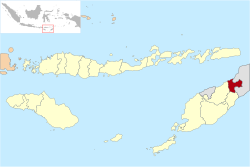
Belu Regency is a regency in East Nusa Tenggara province of Indonesia. Situated on the north side of Timor island, it adjoins the North Central Timor Regency to the west and the separate nation of East Timor to the east. Established on 20 December 1958, [3] Belu Regency has its seat (capital) in the large town of Atambua.

Contents

In December 2012 a separate Regency - Malaka Regency - was created from the twelve districts that formerly comprised the southern half of Belu Regency. "Belu" means "friend" in the indigenous language of Tetum. The residual part of Belu Regency had a population of 188,163 at the 2010 Census, [4] which rose to 206,476 at the 2015 Intermediate Census [5] and to 217,973 at the 2020 Census. [6] The official estimate as at mid 2023 was 231,008 (comprising 115,654 males and 115,354 females). [1]

Administrative Districts

The Belu Regency was until 2013 divided into twenty-four districts (kecamatan), but in December 2012, the twelve southern kecamatan were removed to form the new Malaka Regency, leaving the twelve northern kecamatan in Belu Regency. The residual Belu Regency is thus composed of twelve districts (kecamatan), tabulated below with their areas (in km2) and their populations at the 2010 Census [4] and 2020 Census, [6] together with the official estimates as at mid 2023. [1] The table also includes the locations of the district headquarters, the number of administrative villages in each district (totaling 69 rural desa and 12 urban kelurahan - the latter being the 12 comprising Atambua town), and its postal code.

Kode
Wilayah
Name of
District
(kecamatan)
Area
in
km2
Pop'n
Census
2010
Pop'n
Census
2020
Pop'n
Estimate
mid 2023
Admin
centre
No.
of
villages
Post
code
53.04.12 Kota Atambua
(Central Atambua)
24.9026,39630,83732,747Tenukiik485711
-85718
53.04.21 Atambua Barat
(West Atambua)
15.5521,60424,17825,358Sesekoe485713
-85718
53.04.22 Atambua Selatan
(East Atambua)
15.7322,46426,14427,733Asuulun485716
-85718
Total Atambua town 56.1870,46481,15985,8381285711
-85718
53.04.13Raimanuk179.4214,41116,75517,768Arekama985760
53.04.04Tasifeto Barat
(West Tasifeto)
224.1922,36224,54525,598Kimbana885753
53.04.05Kakulak Mesak187.5417,60821,98823,806Umarese685752
53.04.23Nanaet Dubesi60.254,0064,7835,112Tete Seban485751
53.04.02Tasifeto Timur
(East Tasifeto)
211.3720,93226,12128,275Wedomu1285771
Western rural sector (a)862.7779,31994,192100,55939
53.04.03Raihat87.2013,31914,35914,897Bei Sari Loo685773
53.04.17Lasiolat64.486,1667,0967,503Lafuli785771
53.04.01Lamaknen105.9011,58312,63213,149Weluli985772
53.04.18Lamaknen Selatan
(South Lamaknen)
18.417,3128,5359,062Pie Bulak885770
Eastern salient (b)365.9938,38042,62244,61130
Totals for regency1,284.94188,163217,973231,00881

Note: (a) the five westerly rural kecamatan, mainly surrounding or south of Atambua, including the northern coast.
(b) the area projecting into East Timor.

Media

Belu Regency is served with four radio stations that cover the wider area around this regency (including Malaka Regency, Alor Regency, and Timor Tengah Utara Regency), which are RRI Pro1 Atambua (FM 91.5 MHz) RRI Pro2 Atambua (FM 99.8 MHz) RRI Pro3 (FM 99.0 MHz), and Saluran Citra Budaya Timor (alias Pro4) (FM 93.1 MHz). There's still a lot of radio that can be found in the town.

The regency is only served with two television stations (TVRI - including TVRI East Nusa Tenggara, Belu TV) and a few other East Timor stations that reach the border pass.

Related Research Articles

<span class="mw-page-title-main">Sikka Regency</span> Regency in Lesser Sunda Islands, Indonesia

Sikka is a regency within East Nusa Tenggara province, Indonesia, on the island of Flores. It is bordered to the west by Ende Regency and to the east by East Flores Regency. It covers an area of 1,675.36 km2 and had a population of 300,301 at the 2010 census and 321,953 at the 2020 Census; the official estimate as at mid 2023 was 335,360 - comprising 163,060 males and 172,300 females). The capital is the town of Maumere, which comprises the districts of Alok Barat, Alok and Alok Timur.

<span class="mw-page-title-main">Ende Regency</span> Regency in East Nusa Tenggara, Indonesia

Ende Regency is a regency on the island of Flores, within East Nusa Tenggara Province of Indonesia. The capital is the town of Ende, on the south coast of the Regency. The regency covers an area of 2,085.19 km2, and it had a population of 260,605 at the 2010 Census and 270,763 at the 2020 Census; the official estimate as at mid 2023 was 278,581. It is bordered to the west by Nagekeo Regency and to the east by Sikka Regency, while the Flores Sea lies to the north and the Savu Sea to the south.

<span class="mw-page-title-main">Ende (town)</span> Place in Lesser Sunda Islands, Indonesia

Ende is the seat capital of the Ende Regency, East Nusa Tenggara province of Indonesia. Ende is located on the southern coast of Flores Island. The town had a population of 87,269 residents at the 2020 census, divided administratively between four districts (kecamatan) of the regency – Ende Selatan, Ende Timur, Ende Tengah, and Ende Utara. Note that this does not include Ende District. The official estimate as at mid 2023 was 88,921.

<span class="mw-page-title-main">Solor Archipelago</span> Group of islands in the Lesser Sunda Islands, Indonesia

The Solor Archipelago is a group of islands in the Lesser Sunda Islands, Indonesia, lying to the east of Flores and the west of the Alor Strait and the Alor Archipelago. To the north is the west part of the Banda Sea, while to the south across the Savu Sea lies the island of Timor. The largest islands are, from west to east, Solor, Adonara, and Lembata, although there are many small islands as well.

<span class="mw-page-title-main">Central Sumba Regency</span> Regency in Lesser Sunda Islands, Indonesia

Central Sumba Regency is a regency in East Nusa Tenggara of Indonesia. The new Central Sumba Regency was established on the island of Sumba when West Sumba Regency was split into two regencies on 22 May 2007 and a further Regency was created in Central Sumba from parts of both West Sumba and East Sumba Regencies. The new Regency covers 2,060.54 km2 and had a population of 62,485 at the 2010 Census and 85,482 at the 2020 Census; the official estimate as at mid 2023 was 90,521. The seat (capital) of its government is located at Waibakul.

<span class="mw-page-title-main">East Sumba Regency</span> Regency in Lesser Sunda Islands, Indonesia

East Sumba Regency is geographically the largest of the four regencies which divide the island of Sumba, within East Nusa Tenggara Province of Indonesia. It occupies 62% of the entire island, being much less densely populated than the western third. The town of Waingapu is the capital of East Sumba Regency. The population of East Sumba Regency was 227,732 at the 2010 Census and 244,820 at the 2020 Census; the official estimate as at mid 2022 was 255,498.

<span class="mw-page-title-main">Bima Regency</span> Regency in West Nusa Tenggara, Indonesia

Bima Regency is a regency of the Indonesian Province of West Nusa Tenggara. It is located on the island of Sumbawa and the capital is Woha. The Regency covers an area of 4,389.40 km2, and had a population of 438,522 at the 2010 Census and 514,105 at the 2020 Census; the official estimate as at mid 2022 was 527,952. It administratively excludes but geographically completely surrounds Bima City on the landward side.

<span class="mw-page-title-main">Dompu Regency</span> Regency in West Nusa Tenggara, Indonesia

Dompu Regency is a regency of the Indonesian Province of West Nusa Tenggara. It is located on the island of Sumbawa and the capital is Dompu. It is bordered to the north and to the east by two non-contiguous parts of Bima Regency, and to the west by Sumbawa Regency, as well as on its coasts by Saleh Bay, Sanggar Bay, and Cempi Bay. It covers an area of 2,324.55 km2, and the population at the 2010 Census was 218,984 and at the 2020 Census was 236,665; the official estimate as at mid 2022 was 239,781.

<span class="mw-page-title-main">Sumbawa Regency</span> Regency in West Nusa Tenggara, Indonesia

Sumbawa Regency is a Regency (Kabupaten) of the Indonesian Province of West Nusa Tenggara. It is located on the island of Sumbawa and covers an area of 6,643.98 km2 following the separation on 18 December 2003 of what were until then its westernmost five districts to form the newly-created West Sumbawa Regency. It includes the substantial island of Moyo, lying off the north coast of Sumbawa. The population of the Regency at the 2010 Census was 415,789, which rose at the 2020 Census to 509,753; the official estimate as at mid 2021 was 527,607. The capital is the town of Sumbawa Besar on the north coast of Sumbawa Island.

<span class="mw-page-title-main">West Sumbawa Regency</span> Regency in West Nusa Tenggara, Indonesia

West Sumbawa Regency is a Regency (Kabupaten) of the Indonesian Province of West Nusa Tenggara. It is located on the island of Sumbawa and has an area of 1,743.58 km2. The regency was created on 18 December 2003 from what were at that time the westernmost five districts (kecamatan) of Sumbawa Regency. The population at the 2010 Census was 114,754, and at the 2020 Census was 145,798; the official estimate as at mid 2022 was 151,775 - comprising 76,959 males and 74,816 females. The capital is the town of Taliwang.

Kefamenanu is a town and capital of the administrative district (kecamatan) of Kota Kefamenanu and of the North Central Timor Regency in West Timor, Indonesia. A road connects it to Halilulik and Kota Atambua to the northeast. It had a population of 43,058 at the 2010 Census and 47,766 at the 2020 Census; the official estimate in mid 2023 was 49,589. The town hosts the University of Timor, one of the two public universities in the Indonesian part of the island.

<span class="mw-page-title-main">East Flores Regency</span> Regency in East Nusa Tenggara, Indonesia

East Flores Regency is a regency in East Nusa Tenggara province of Indonesia. Established in 1958, the regency has its seat (capital) in Larantuka on Flores Island. It covers a land area of 1,812.58 km2, and it had a population of 232,605 as of the 2010 census and 276,896 at the 2020 Census; the official estimate as of mid-2023 was 288,310 - comprising 141,738 males and 146,572 females. The regency encompasses the eastern tip of the island of Flores, together with all of the adjacent islands of Adonara and Solor to the east of Flores, with some much smaller offshore islands. On 4 October 1999, the island of Lembata at the eastern end of the Solor Archipelago was separated from the East Flores Regency to create its own Regency.

<span class="mw-page-title-main">Manggarai Regency</span> Regency in East Nusa Tenggara, Indonesia

Manggarai Regency is a regency in East Nusa Tenggara province of Indonesia, situated on the island of Flores. Established in 1958 the regency was reduced in size and population by the separation of the more western districts to form West Manggarai Regency in 2003 and of the more eastern districts to form East Manggarai Regency in 2007. The area of the residual Manggarai Regency is 1,343.83 km2 and its population was 292,037 at the 2010 census and 312,855 at the 2020 census; the official estimate as at mid 2023 was 328,758. The capital of the regency is the town of Ruteng.

<span class="mw-page-title-main">Kupang Regency</span> Regency in Lesser Sunda Islands, Indonesia

Kupang Regency is a regency in East Nusa Tenggara province of Indonesia. It occupies the far western end of Timor Island, together with the smaller island of Semau and other minor offshore islands. Other islands further to the southwest and west which were formerly part of Kupang Regency have been separated administratively - the Rote Islands Group on 10 April 2002, and the Savu Islands on 29 October 2008.

<span class="mw-page-title-main">South Central Timor Regency</span> Regency in Lesser Sunda Islands, Indonesia

South Central Timor Regency is a regency in East Nusa Tenggara province of Indonesia. Established in 1958, the regency has its seat (capital) in the town of Soe. It covers an area of 3,955.36 km2 and had a population of 440,470 at the 2010 Census and 455,410 at the 2020 Census; the official estimate as at mid 2023 was 474,521.

<span class="mw-page-title-main">North Central Timor Regency</span> Regency of Indonesia

North Central Timor Regency is a regency in East Nusa Tenggara Province, Indonesia. It covers an area of 2,669.70 km2, and had a population of 229,803 at the 2010 Census and 259,829 at the 2020 Census; the official estimate as at mid 2023 was 271,277. Its regency seat is located at the town of Kefamenanu, which had a population of 49,589 in mid 2023. The regency borders Timor Leste's Oecusse enclave, one of few Indonesian regions that have a land border with other countries.

<span class="mw-page-title-main">Lembata Regency</span> Regency in East Nusa Tenggara, Indonesia

Lembata Regency is a regency in East Nusa Tenggara province of Indonesia. Established on 4 October 1999 from the most easterly part of East Flores Regency, the regency covers the island of Lembata, together with three small offshore islands together forming the eastern part of the Solor Archipelago, and has its administrative seat (capital) in Lewoleba. The population of the Regency was 117,829 at the 2010 decennial census and at the 2020 census was 135,930; the official estimate as at mid 2023 was 141,391 - comprising 68,409 males and 72,982 females.

<span class="mw-page-title-main">Southwest Sumba Regency</span> Regency in Lesser Sunda Islands, Indonesia

Southwest Sumba Regency is a regency on Sumba Island in East Nusa Tenggara province of Indonesia. Established on 2 January 2007 out of parts of West Sumba Regency, the regency has its seat (capital) in Tambolaka. Its population was 283,818 in the 2010 decennial census and had risen to 303,650 at the 2020 census; the official estimate as at mid 2022 was 322,073 (comprising 164,825 males and 157,248 females

<span class="mw-page-title-main">Sabu Raijua Regency</span> Regency in Lesser Sunda Islands, Indonesia

Sabu Raijua Regency is one of the regencies in the province of East Nusa Tenggara, Indonesia. It comprises the three Savu Islands, lying between Sumba and Rote Island in the Savu Sea, with a land area of 459.58 km2. The regency was established by Indonesia's Minister of Home Affairs, Mardiyanto, on 29 October 2008, when it was partitioned from Kupang Regency. The population was 72,960 at the 2010 census, and 89,327 at the 2020 Census; the official estimate as at mid 2023 was 93,330.

<span class="mw-page-title-main">Malaka Regency</span> Regency in Lesser Sunda Islands, Indonesia

Malaka Regency is a regency in the province of East Nusa Tenggara, Indonesia. The regency was established on 14 December 2012, comprising twelve districts which had formerly been the southern part of Belu Regency.

References

  1. 1 2 3 Badan Pusat Statistik, Jakarta, 28 February 2024, Kabupaten Belu Dalam Angka 2024 (Katalog-BPS 1102001.5304)
  2. "Kabupaten Belu Dalam Angka 2019". www.belukab.bps.go.id (in Indonesian). Retrieved 13 February 2020.
  3. Government of Indonesia (9 August 1958), Establishment of the Second-level Administrative Regions under the First-level Administrative Region of Bali, West Nusa Tenggara and East Nusa Tenggara (in Indonesian  ed.), Indonesia Ministry of Law and Justice, UU No. 69/1958, retrieved 24 August 2007[ permanent dead link ]
  4. 1 2 Biro Pusat Statistik, Jakarta, 2011.
  5. Badan Pusat Statistik, Jakarta, 2018.
  6. 1 2 Badan Pusat Statistik, Jakarta, 2021.