
Timor is an island at the southern end of Maritime Southeast Asia, in the north of the Timor Sea. The island is divided between the sovereign states of East Timor on the eastern part and Indonesia on the western part. The Indonesian part, also known as West Timor, constitutes part of the province of East Nusa Tenggara. Within West Timor lies an exclave of East Timor called Oecusse District. The island covers an area of 30,777 square kilometres. The name is a variant of timur, Malay for "east"; it is so called because it lies at the eastern end of the Lesser Sunda Islands. Mainland Australia is less than 500 km away, separated by the Timor Sea.
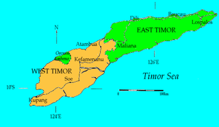
West Timor is an area covering the western part of the island of Timor, except for the district of Oecussi-Ambeno. Administratively, West Timor is part of East Nusa Tenggara Province, Indonesia. The capital as well as its main port is Kupang. During the colonial period, the area was named Dutch Timor and was a centre of Dutch loyalists during the Indonesian National Revolution (1945–1949). From 1949 to 1975 it was named Indonesian Timor.

Banten is the westernmost province on the island of Java, Indonesia. Its capital city is Serang. The province borders West Java and the Special Capital Region of Jakarta on the east, the Java Sea on the north, the Indian Ocean on the south, and the Sunda Strait on the west. The province covers an area of 9,662.82 km2 (3,730.84 sq mi). It had a population of over 11.9 million in the 2020 census, up from about 10.6 million in 2010. The estimated mid-2021 population was 12.06 million. Formerly part of the province of West Java, Banten was declared a separate province in 2000. The region is the homeland of the Bantenese people, whose culture differs slightly from that of West Java's Sundanese people. The northern half has recently experienced rapid rises in population and urbanization, and the southern half has a more traditional character.

East Java is a province of Indonesia located in the easternmost hemisphere of Java island. It has a land border only with the province of Central Java to the west; the Java Sea and the Indian Ocean border its northern and southern coasts, respectively, while the narrow Bali Strait to the east separates Java from Bali by around 2.29 kilometres (1.42 mi). Located in eastern Java, the province also includes the island of Madura, as well as the Kangean islands and other smaller island groups located further east and Masalembu archipelagos in the north. Its capital is Surabaya, the second largest city in Indonesia, a major industrial center and also a major business center. Banyuwangi is the largest regency in East Java and the largest on the island of Java.

Bengkulu is a province of Indonesia. It is located on the southwest coast of Sumatra. It was formed on 18 November 1968 by separating out the former Bencoolen Residency area from the province of South Sumatra under Law No. 9 of 1967 and was finalized by Government Regulation No. 20 of 1968. Spread over 19,813 km2, it is bordered by the provinces of West Sumatra to the north, Jambi to the northeast, Lampung to the southeast, and South Sumatra to the east, and by the Indian Ocean to the northwest, south, southwest, and west.

East Nusa Tenggara is the southernmost province of Indonesia. It comprises the eastern portion of the Lesser Sunda Islands, facing the Indian Ocean in the south and the Flores Sea in the north. It consists of more than 500 islands, with the largest ones being Sumba, Flores, and the western part of Timor; the latter shares a land border with the separate nation of East Timor. The province is subdivided into twenty-one regencies and the regency-level city of Kupang, which is the capital and largest city.

West Nusa Tenggara is a province of Indonesia. It comprises the western portion of the Lesser Sunda Islands, with the exception of Bali which is its own province. Mataram, on Lombok, is the capital and largest city of the province. The 2010 census recorded the population at 4,500,212; the total rose to 4,830,118 at the 2015 census and 5,320,092 at the 2020 census; the official estimate as at mid 2021 was 5,390,000. The province's area is 20,153.15 km2. The two largest islands by far in the province are Lombok in the west and the larger Sumbawa island in the east.

Kupang, formerly known as Koepang, is the capital of the Indonesian province of East Nusa Tenggara. At the 2020 Census, it had a population of 442,758; the official estimate as at mid 2021 was 455,850. It is the largest city and port on the island of Timor, and is a part of the Timor Leste–Indonesia–Australia Growth Triangle free trade zone. Geographically, Kupang is the southernmost city in Indonesia.

Palu, which is officially known as the City of Palu, is the capital and largest city of Central Sulawesi. Palu is located on the northwestern coast of Sulawesi and borders Donggala Regency to the north and west, Parigi Moutong Regency to the east, and Sigi Regency to the south. The city boundaries encompass a land area of 395.06 km2 (152.53 sq mi). According to the 2020 Indonesian census, Palu has a population of 373,218, making it the third-most populous city on the island after Makassar and Manado; the official estimate as at mid 2021 was 377,030. Palu is the center of finance, government, and education in Central Sulawesi, as well as one of several major cities on the island. The city hosts the province's main port, its biggest airport, and most of its public universities.

Sukabumi Regency is a regency (kabupaten) in southwestern Java, as part of West Java province of Indonesia. The regency seat is located in Palabuhan Ratu, a coastal district facing the Indian Ocean. The regency fully encircles the administratively separated city of Sukabumi. Covering an area of 4,145.70 km2, the regency is the largest regency in West Java and the second largest regency on Java after the Banyuwangi Regency in East Java. The regency had a population of 2,341,409 at the 2010 census and 2,725,450 at the 2020 census; the official estimate as at mid 2021 was 2,761,476 with a large part of it living in the northeastern part of the regency that encircles Sukabumi City, south of Mount Gede. A plan to create a new regency, the North Sukabumi Regency is currently waiting for the approval of the central government.
Atambua is the regency seat of Belu Regency, East Nusa Tenggara, Indonesia.

Palabuhanratu or Pelabuhan Ratu is a district and fishing town which serves as the regency seat of Sukabumi Regency. It is at the southwest coast of Palabuhanratu Bay, West Java facing the Indian Ocean. It is a four-hour drive from Bandung and up to a 12-hour drive from Indonesia's capital Jakarta due to traffic jams in Ciawi, Cicurug, Cibadak and Pelabuhan Ratu gate, whose residents love to visit the bay 'Teluk Palabuhanratu', once named 'Wijnkoopersbaai' by the Dutch. The bay is shaped like a horseshoe and has enormous waves that can be very treacherous. The Sundanese locals say that the Indian Ocean is the home of Nyai Loro Kidul who reigns along the southern coast of Java.

Belu Regency is a regency in East Nusa Tenggara province of Indonesia. Established on 20 December 1958, Belu Regency has its seat (capital) in the large town of Atambua.
Mota'ain, also spelled Motain, Mota'in or Mota Ain, is a hamlet in the Silawan village (desa), East Tasifeto district (kecamatan), Belu Regency, East Nusa Tenggara, Indonesia.
Amarasi was a traditional princedom in West Timor, in present-day Indonesia. It had an important role in the political history of Timor during the 17th and 18th century, being a client state of the Portuguese colonialists, and later subjected to the Netherlands East Indies.

North Central Timor Regency is a regency in East Nusa Tenggara Province, Indonesia. It covers an area of 2,669.70 km2, and had a population of 229,803 at the 2010 Census and 259,829 at the 2020 Census; the official estimate as at mid 2021 was 262,598. Its regency seat is located at the town of Kefamenanu, which had a population of 48,202 in mid 2021. The regency borders Timor Leste's Oecusse enclave, one of few Indonesian regions that have a land border with other countries.

Rote Ndao Regency is a regency in East Nusa Tenggara province of Indonesia, consisting primarily of the island of Rote, situated south-west of the western tip of West Timor with an area of 978.54 km2, together with minor offshore islands including Usu, Ndana, Ndao, Landu and Nuse; the total area including the minor offshore islands is 1,280.10 km2. The regency seat is in the village of Ba'a, which is situated in Lobalain District. The population of the Regency was 119,908 as of the 2010 census and 143,764 at the 2020 Census; the official estimate as at mid 2021 was 145,972.
Sacato, sometimes spelled Sakato, is a village in East Timor. It is located in the suco of Nipane within the Pante Macassar Administrative Post in the Oecusse Special Administrative Region. It also the main border crossing between the East Timorese exclave of Oecusse and Indonesia.

João da Costa Tavares was the Commander-in-Chief of the pro-Indonesian Militia in East Timor. He was also a pro-integration militiamen.

The Noelmina Bridge is a bridge located in Noelmina Village, Takari District, Kupang Regency, East Nusa Tenggara. The Noelmina Bridge is the entrance gate to Kupang Regency from the South Central Timor Regency direction. This bridge is also a link between the City of Kupang and the Kupang Regency with South Central Timor Regency, North Central Timor Regency, Belu Regency, and Malaka Regency.


