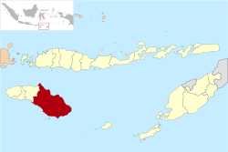
East Sumba Regency

Last updated
East Sumba Regency
Kabupaten Sumba Timur
Lambang Kabupaten Sumba Timur.jpg
Lokasi Nusa Tenggara Timur Kabupaten Sumba Timur.svg
Location within East Nusa Tenggara
Sumba Locator Topography.png
Red pog.svg
East Sumba Regency
Indonesia Lesser Sunda Islands location map.svg
Red pog.svg
East Sumba Regency
East Sumba Regency (Lesser Sunda Islands)
Indonesia location map.svg
Red pog.svg
East Sumba Regency
East Sumba Regency (Indonesia)
Coordinates: 9°53′00″S120°15′00″E / 9.8833°S 120.2500°E / -9.8833; 120.2500
Country Flag of Indonesia.svg  Indonesia
Region Lesser Sunda Islands
Province Flag of East Nusa Tenggara.svg  East Nusa Tenggara
Capital Waingapu
Government
  RegentGidion Mbilijora
  Vice RegentUmbu Lili Pekuwali
Area
  Total7,000.5 km2 (2,702.9 sq mi)
Population
 (mid 2023 estimate)
  Total255,498
  Density36/km2 (95/sq mi)
  [1]
Time zone UTC+8 (ICST)
Area code (+62) 387
Website sumbatimurkab.go.id

East Sumba Regency (Indonesian : Kabupaten Sumba Timur) is geographically the largest of the four regencies which divide the island of Sumba, within East Nusa Tenggara Province of Indonesia. It occupies 62% (nearly two-thirds) of the entire island, being much less densely populated than the western third. The town of Waingapu is the capital of East Sumba Regency (its urban area comprises the kecamatan of Kota Waingapu and Kambera). The population of East Sumba Regency was 227,732 at the 2010 Census [2] and 244,820 at the 2020 Census; [3] the official estimate as at mid 2022 was 255,498 (comprising 131,082 males and 124,416 females). [1]

Contents

Administrative Districts

The East Sumba Regency is composed of twenty-two districts (kecamatan), whose areas (in km2) and populations at the 2010 Census [2] and 2020 Census [3] are listed below, together with the official estimates as at mid 2023. [1] The table also includes the locations of the district headquarters, the number of administrative villages in each district (totaling 140 rural desa and 16 urban kelurahan), and its postal code.

Kode
Wilayah
Name of
District
(kecamatan)
Area
in
km2
Pop'n
Census
2010
Pop'n
Census
2020
Pop'n
Estimate
mid 2023
Admin
centre
No.
of
villages
Post
code
53.11.03Lewa281.115,42315,40415,736Pamati Karata8 (a)87150
53.11.04Nggaha Oriangu286.48,6149,61110,408Karipidita887155
53.11.18Lewa Tidahu322.16,1296,8267,195Laikeri687151
53.11.19Katala Hamu Lingu453.13,6994,0434,238Kombapari587152
53.11.05Tabandung514.48,3019,0519,481Malahar1087160
53.11.06Pinupahar246.66,4106,8557,141Tawui687161
53.11.12Paberiwai199.75,6196,2216,546Kananggar787175
53.11.13Karera (b)334.67,3657,6687,925Nggongi787172
53.11.15Matawai La Pawu405.45,7866,0926,317Tanarara687174
53.11.14Kahaungu Eti475.18,2148,7259,071Kamanggih987171
53.11.22Mahu196.63,9224,1194,268Wairara687170
53.11.21Ngadu Ngala207.94,7875,0475,236Praiwitu587172
53.11.10Pahunga Lodu349.812,24713,06613,601Ngala887182
53.11.11Wula Waijelu221.36,9027,6368,033Wula787183
53.11.09Rindi366.59,0709,62810,007Tanaraing887181
53.11.08Umalulu307.916,25117,66717,987Melolo10 (c)87180
53.11.07Pandawai412.614,77617,29818,498Kawangu7 (d)87176
53.11.17Kambata Mapambuhang412.73,4343,8224,028Lukuwingir887171
(e)
53.11.01Kota Waingapu 73.835,14235,85636,841Waingapu7 (f)87111-87116
53.11.16Kambera52.031,13733,46634,911Pakukinjara8 (g)87113-87116
53.11.02Haharu601.55,5866,2486,594Rambangaru1087153
53.11.20Kanatang279.48,91810,27110,932Temu7 (h)87154
Totals7,000.5227,732244,820255,498Waingapu156

Note: (a) includes the kelurahan of Lewa Paku. (b) includes islands off the south of Sumba Island, the largest being Pulau Halura, Pulau Manggudu and Pulau Koatak. (c) includes the kelurahan of Lumbukore.
(d) includes the 2 kelurahan of Kawangu and Watumbaka. (e) except village of Lukuwingir (which has a postcode of 87116).
(f) comprises 4 kelurahan (Hambala, Kamalaputi, Kambajawa and Matawai) and 3 desa.
(g) comprises 7 kelurahan (Kambaniru, Lai Mbonga, Lambanapu, Malumbi, Mau Hau, Prailiu and Wangga) and 1 desa.
(h) includes the kelurahan of Temu.

Airport

Umbu Mehang Kunda Airport, formerly known as Mau Hau Airport, is situated east of Waingapu near the mouth of the Kambaniru River. It has a 6,070-ft (1,850 metres) long runway with 98-ft (30 metres) width, which can accommodate Boeing 737-300 aircraft. The airport inaugurated a new terminal in 2016 which has been able to improve the passenger services compared with the previous old terminal.

Related Research Articles

<span class="mw-page-title-main">Waingapu</span> Place in Lesser Sunda Islands, Indonesia

Waingapu is the largest town in the eastern half of the island of Sumba, East Nusa Tenggara, Indonesia. It is the capital town of the Regency of Sumba Timur. The town comprises two administrative Districts of the regency, sub-divided into 11 urban (kelurahan) and 4 rural (desa) villages. The western part is the administrative Waingapu Town District, while the eastern part is the separate Kambera District. Their areas and their populations at the 2010 and 2020 Censuses are tabled below, together with the official estimates as at mid 2022.

<span class="mw-page-title-main">Sikka Regency</span> Regency in Lesser Sunda Islands, Indonesia

Sikka is a regency within East Nusa Tenggara province, Indonesia, on the island of Flores. It is bordered to the west by Ende Regency and to the east by East Flores Regency. It covers an area of 1,731.91 km2 and had a population of 300,301 at the 2010 census and 321,953 at the 2020 Census; the official estimate as at mid 2022 was 326,999. The capital is the town of Maumere, which comprises the districts of Alok Barat, Alok and Alok Timur.

<span class="mw-page-title-main">Maumere</span> Town in Lesser Sunda Islands, Indonesia

Maumere is the administrative seat of the Sikka Regency and the second largest town on Flores Island, Indonesia. It lies on the north coast of the island and the port is in the north-west part of the town. Administratively the town is not a single district (kecamatan) within the regency, but is divided into three districts – Alok Barat, Alok and Alok Timur – although the latter two districts also include a number of substantial islands off the north coast of Flores.

<span class="mw-page-title-main">Tangerang Regency</span> Regency of Indonesia

Tangerang Regency is a regency of Banten Province, Indonesia. It is located in the northwest of the island of Java. The current regent is Ahmed Zaki Iskandar. Though commonly misunderstood as being a part of Jakarta, Tangerang is actually outside Jakarta City but is part of Greater Jakarta. Since 1993, the regency has lost territory as first Tangerang city was split off on 27 February 1993 and subsequently South Tangerang city was split off on 29 October 2008. The residual Regency now has an area of 1,034.54 km2 and a population of 2,834,376 at the 2010 census, growing to 3,245,619 at the 2020 census; the latest official estimate is 3,309,365, reflecting a recent slowing down in the rate of population growth since 2020. The town of Tigaraksa is the regency seat.

<span class="mw-page-title-main">Pamekasan Regency</span> Regency of Indonesia

Pamekasan Regency is a regency (kabupaten) of the province of East Java, Indonesia. It is located on Madura Island approximately 120 kilometres (75 mi) east of Surabaya, the provincial capital. The regency covers an area of 792.30 square kilometres (305.91 sq mi), and at the 2010 census it had a population of 795,918 ; at the 2020 census the total was 850,057 and the official estimate as of mid-2022 was 857,818 – comprising 420,612 males and 437,206 females. The administrative capital is the town of Pamekasan.

<span class="mw-page-title-main">Sampang Regency</span> Regency of Indonesia

Sampang Regency is a regency of East Java province, Indonesia. It is situated on Madura Island, bordering on Pamekasan Regency to the east, the Java Sea to the north, Bangkalan Regency to the west, and Madura Strait to the south. It covers an area of 1,233.3 km2, and had a population of at the 2010 census 877,772 and at the 2020 census 969,694; the official estimate as of mid-2022 was 984,162 - comprising 488,673 males and 495,489 females. The administrative centre is the port of Sampang, on the south coast of Madura.

<span class="mw-page-title-main">West Kutai Regency</span> Regency in Kalimantan, Indonesia

West Kutai Regency is a regency (kabupaten) in the Indonesian province of East Kalimantan. It previously covered a much greater area, with a population of 165,091 at the 2010 Census, but in December 2012 the five northernmost districts were split off to form a new Mahakam Ulu Regency; the residual area of 20,384.6 km2 had a population of 140,097 at the 2010 Census, and 165,938 at the 2020 Census; the official estimate as at mid 2022 was 172,288. The town of Sendawar is the administrative capital.

<span class="mw-page-title-main">East Luwu Regency</span> Regency in South Sulawesi, Indonesia

East Luwu Regency is the most easterly of the twenty-one regencies in South Sulawesi Province of Indonesia. The regency was created on 25 February 2003 by separation of the eastern districts from North Luwu Regency. It covers an area of 6,944.88 km2. The administrative capital of the regency is the coastal town of Malili on the Bay of Usu, itself an inlet in the northeast corner of the Gulf of Bone; the town, with its port of Balantang, is the shipping port for one of the world's major nickel-producing plants. The population of the Regency was 243,069 at the 2010 Census and 296,741 at the 2020 Census; the official estimate as at mid 2022 was 305,521.

<span class="mw-page-title-main">West Sumbawa Regency</span> Regency in West Nusa Tenggara, Indonesia

West Sumbawa Regency is a Regency (Kabupaten) of the Indonesian Province of West Nusa Tenggara. It is located on the island of Sumbawa and has an area of 1,743.58 km2. The regency was created on 18 December 2003 from what were at that time the westernmost five districts (kecamatan) of Sumbawa Regency. The population at the 2010 Census was 114,754, and at the 2020 Census was 145,798; the official estimate as at mid 2022 was 151,775 - comprising 76,959 males and 74,816 females. The capital is the town of Taliwang.

<span class="mw-page-title-main">East Flores Regency</span> Regency in East Nusa Tenggara, Indonesia

East Flores Regency is a regency in East Nusa Tenggara province of Indonesia. Established in 1958, the regency has its seat (capital) in Larantuka on Flores Island. It covers a land area of 1,812.85 km2, and it had a population of 232,605 as of the 2010 census and 276,896 at the 2020 Census; the official estimate as of mid-2022 was 288,897. The regency encompasses the eastern tip of the island of Flores, together with all of the adjacent islands of Adonara and Solor to the east of Flores, with some much smaller offshore islands. On 4 October 1999, the island of Lembata at the eastern end of the Solor Archipelago was separated from the East Flores Regency to create its own Regency.

<span class="mw-page-title-main">Manggarai Regency</span> Regency in East Nusa Tenggara, Indonesia

Manggarai Regency is a regency in East Nusa Tenggara province of Indonesia, situated on the island of Flores. Established in 1958 the regency was reduced in size and population by the separation of West Manggarai Regency in 2003 and of East Manggarai Regency in 2007. The area of the residual Manggarai Regency is 1,344.03 km2 and its population was 292,037 at the 2010 census and 312,855 at the 2020 census; the official estimate as at mid 2022 was 317,646. The capital of the regency is the town of Ruteng.

<span class="mw-page-title-main">Paser Regency</span> Regency in East Kalimantan, Indonesia

Paser Regency is a regency (kabupaten) within East Kalimantan province in Indonesia, it is the southernmost regency of the East Kalimantan province. Its administrative centre is Tana Paser. It covers an area of 7,730 km2, and it had a population of 230,316 at the 2010 Census and 275,452 at the 2020 Census; the official estimate as at mid-2022 was 280,065 . Before 2007, this regency was formerly named Pasir Regency.

<span class="mw-page-title-main">Meranti Islands Regency</span> Regency in Riau, Indonesia

Meranti Islands is an archipelago forming a regency (kabupaten) of Riau Province and lies off the eastern coast of the island of Sumatra, Indonesia. It was created on 19 December 2008 by the separating of this archipelago from the mainland regency of Bengkalis. The regency comprises the islands of Tebing Tinggi, Rangsang, Padang, and Merbau, together with minor offshore islands, but does not include Bengkalis Island which is geographically part of the archipelago but remains within Bengkalis Regency. The principal town is Selat Panjang on Tebing Tinggi Island. The regency covers an area of 3,623.93 km2 and had a population of 176,290 at the 2010 Census and 206,116 at the 2020 Census; the official estimate as of mid-2022 was 213,532.

<span class="mw-page-title-main">North Barito Regency</span> Regency in Kalimantan, Indonesia

North Barito Regency is one of the thirteen regencies which divide the Central Kalimantan Province on the island of Kalimantan, Indonesia. It originally included much more of the northern part of the province, but on 10 April 2002 the larger northwestern part of the regency was split off to create a new Murung Raya Regency. Muara Teweh is the capital of North Barito Regency, which covers an area of 10,152.25 km2. The population of North Barito Regency was 121,573 at the 2010 Census and 154,812 at the 2020 Census; the official estimate as at mid 2022 was 160,235.

<span class="mw-page-title-main">Sukamara Regency</span> Regency of Indonesia

Sukamara Regency is one of the thirteen regencies which comprise the Central Kalimantan Province on the island of Kalimantan (Borneo), Indonesia. It was created on 10 April 2002 from the former southwest part of West Kotawaringin Regency. The town of Sukamara is the capital of Sukamara Regency, which covers an area of 3,827 km2. The population of the Regency was 44,952 at the 2010 Census and 63,464 at the 2020 Census; the official estimate as at mid 2022 was 66,845.

<span class="mw-page-title-main">Kolaka Regency</span> Regency in Southeast Sulawesi, Indonesia

Kolaka Regency is a regency of Southeast Sulawesi Province, Indonesia. It covers an area of 2,958.69 km2 (1,142.36 sq mi) and had a population of 208,817 at the 2010 Census, rising to 237,587 at the 2020 Census; the official estimate as at mid 2022 was 246,137. The principal town lies at Kolaka.

<span class="mw-page-title-main">South Konawe Regency</span> Regency in Southeast Sulawesi, Indonesia

South Konawe Regency is a regency of Southeast Sulawesi Province, Indonesia. It covers an area of 4,237.74 km2 and had a population of 264,587 at the 2010 Census and of 308,524 at the 2020 Census; the official estimate as at mid 2022 was 317,826 - comprising 162,949 males and 154,877 females. The administrative centre is in the town of Andoolo.

<span class="mw-page-title-main">North Bolaang Mongondow Regency</span> Regency in North Sulawesi, Indonesia

North Bolaang Mongondow Regency is a regency of North Sulawesi Province of Indonesia. It was created on 2 January 2007 by splitting off districts which were previously part of Bolaang Mongondow Regency. The regency covers an area of 1,672.61 km2 and had a population of 70,693 at the 2010 Census and 83,112 at the 2020 Census; the official estimate as at mid 2022 was 84,543. Bitauna is the only official town (kelurahan) in the regency, but the administrative centre is at Boroko.

<span class="mw-page-title-main">Manokwari Regency</span> Regency in West Papua, Indonesia

Manokwari Regency is a regency in West Papua, Indonesia. Following the splitting away of twenty of its former districts in 2013, it now covers an area of 3,168.28 km2 and had a population of 192,663 at the 2020 Census; the official estimate as at mid 2022 was 200,785. The administrative centre is presently at the town of Manokwari, which is also the capital of the province, but under proposals currently under consideration by the Indonesian Parliament, the town is intended to be split off from the regency to form a separate independent city.

<span class="mw-page-title-main">Jembrana Regency</span> Regency in Bali, Indonesia

Jembrana Regency is a regency (kabupaten) in the southwest of Bali, Indonesia. It has an area of 841.8 km2 and had a population of 261,638 at the 2010 Census and 317,064 at the 2020 Census; the official estimate as at mid 2022 was 327,850. Its regency seat is the town of Negara.

References

  1. 1 2 3 Badan Pusat Statistik, Jakarta, 28 February 2024, Kabupaten Sumba Timur Dalam Angka 2024 (Katalog-BPS 1102001.5311)
  2. 1 2 Biro Pusat Statistik, Jakarta, 2011.
  3. 1 2 Badan Pusat Statistik, Jakarta, 2021.