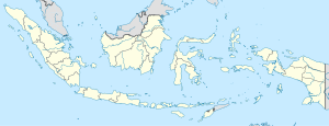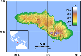
Sumba, natively also spelt as Humba, Hubba, Suba, or Zuba is an Indonesian island located in the Eastern Indonesia and administratively part of the East Nusa Tenggara provincial territory. Sumba has an area of 11,243.78 square kilometres, about the same size as Jamaica or Hawaii (Island). The population was 686,113 at the 2010 Census and 779,049 at the 2020 Census; the official estimate as of mid-2023 was 820,506. To the northwest of Sumba is Sumbawa, to the northeast, across the Sumba Strait, is Flores, to the east, across the Savu Sea, is Timor, and to the south, across part of the Indian Ocean, is Australia.

East Nusa Tenggara is the southernmost province of Indonesia. It comprises the eastern portion of the Lesser Sunda Islands, facing the Indian Ocean in the south and the Flores Sea in the north. It consists of more than 500 islands, with the largest ones being Sumba, Flores, and the western part of Timor; the latter shares a land border with the separate nation of East Timor. The province is subdivided into twenty-one regencies and the regency-level city of Kupang, which is the capital and largest city.

The Sunda Islands are a group of islands in the Malay Archipelago. They consist of the Greater Sunda Islands and the Lesser Sunda Islands.

The Nottaway River is a river in Quebec, Canada. The river drains Lake Matagami and travels 225 kilometers (140 mi) north-west before emptying into Rupert Bay at the south end of James Bay. Its drainage basin is 65,800 square kilometers (25,400 sq mi) and has a mean discharge of 1190 m3/s. Its source is the head of the Mégiscane River, which is 776 kilometers (482 mi) from the mouth.

Onekotan is an uninhabited volcanic island located near the northern end of the Kuril Islands chain in the Sea of Okhotsk in the northwest Pacific Ocean. Its name is derived from the Ainu language for "large village”. It is the second largest island, after Paramushir, in the northern subgroup of the Kurils. It is administratively included in the Severo-Kurilsky District of Sakhalin oblast, Russia.
The Central Malayo-Polynesian languages (CMP) are a proposed branch in the Malayo-Polynesian subgroup of the Austronesian language family. The languages are spoken in the Lesser Sunda and Maluku Islands of the Banda Sea, in an area corresponding closely to the Indonesian provinces of East Nusa Tenggara and Maluku and the nation of East Timor, but with the Bima language extending to the eastern half of Sumbawa Island in the province of West Nusa Tenggara and the Sula languages of the Sula archipelago in the southwest corner of the province of North Maluku. The principal islands in this region are Sumbawa, Sumba, Flores, Timor, Buru, and Seram. The numerically most important languages are Bima, Manggarai of western Flores, Uab Meto of West Timor, and Tetum, the national language of East Timor.
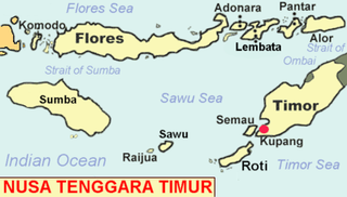
Savu is the largest of a group of three islands, situated midway between Sumba and Rote, west of Timor, in Indonesia's eastern province, East Nusa Tenggara. Ferries connect the islands to Waingapu on Sumba, Ende on Flores, and Kupang in West Timor. Flying to Savu through Susi Air from Kupang, Ende, and Waingapu is also possible.
Sumba Strait is a strait in Indonesia.

Umbu Mehang Kunda Airport, also formerly known as Mau Hau Airport, is an airport serving Waingapu, the largest town on the island of Sumba, in the province of East Nusa Tenggara in Indonesia.

West Sumba Regency is a regency in East Nusa Tenggara Province of Indonesia. Established in 1958, the regency was considerably reduced on 2 January 2007 with the creation of new Regencies on Sumba Island under Law UU No.16 of that year. Its area is now 737.42 km2, and its population was 110,993 at the 2010 census and 145,097 at the 2020 Census; the official estimate as at mid 2023 was 152,414. It has its seat (capital) in (Kota) Waikabubak.

Central Sumba Regency is a regency in East Nusa Tenggara of Indonesia. The new Central Sumba Regency was established on the island of Sumba when West Sumba Regency was split into two regencies on 22 May 2007 and a further Regency was created in Central Sumba from parts of both West Sumba and East Sumba Regencies. The new Regency covers 2,060.54 km2 and had a population of 62,485 at the 2010 Census and 85,482 at the 2020 Census; the official estimate as at mid 2023 was 90,521. The seat (capital) of its government is located at Waibakul.
Continental crustal fragments, partly synonymous with microcontinents, are pieces of continents that have broken off from main continental masses to form distinct islands that are often several hundred kilometers from their place of origin.
The Sumba–Hawu languages are a group of closely related Austronesian languages, spoken in East Nusa Tenggara, Indonesia.
The Polapare River is a river of Sumba Barat Daya Regency in the island of Sumba, East Nusa Tenggara, Indonesia. The length of the river is 18 km. Offshore of the river mouth are the islands of Baholokmonegoro and Barenggemonokodi; Malondobara Island is 1¼ km to the west.

Anakalang is a village area (desa) and a small kingdom in the western part of Sumba island, in eastern Indonesia. It is noted for numerous megalithic tombs and its quadrangular adzes.

The Sumba people are an ethnic group inhabiting Sumba Island in Indonesia, which is divided by four regencies, namely the Southwest Sumba Regency, West Sumba Regency, Central Sumba Regency, and the East Sumba Regency. They refer to themselves as Tau Humba. The Sumbese have been able to retain much of their culture despite foreign influences that arrived long ago on the Lesser Sunda Islands.
The Kambaniru River is a river in the island of Sumba, Indonesia, about 1,500 km east of the capital Jakarta. With a length of approximately 118 km, it flows periodically through 9 districts in the East Sumba Regency, exiting to the Bay of Kambaniru near the city of Waingapu to the Sawu Sea, with high debit in the wet season, but very low in the dry season.
The Wanokaka River is a river in Sumba island, Province of East Nusa Tenggara, Indonesia. It is located a few kilometers south of Waikabubak, with the District of Wanokaka (Wanukaka), east of the District of Lamboya.
The Sumba languages are a subgroup of the Austronesian language family, spoken on Sumba, an island in eastern Indonesia. They are closely related to the Hawu–Dhao languages.

Waiyapu is a traditional village (desa) on Sumba island, East Nusa Tenggara province, Indonesia.