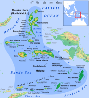
Weber Deep (Indonesian : Kedalaman Weber) is the deepest point in the Banda Sea off Indonesia. Weber Deep maximum depth is 7,351 meters, (24,117 feet, 4.56 miles). Banda Sea is connected to the Pacific Ocean, near the Maluku Islands of Indonesia in the Banda Arc. Weber Deep differs from other deep sea points in that Weber Deep is not a deep sea trench, but is a forearc basin, a deep abyssal plain. The slab detachment is at the east end of the deep. Weber Deep is the 16th deepest point in the Earth's oceans and seas. [1]
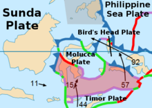
Researchers believe that the Weber Deep was formed when part of the Earth's crust broke off along a 120 km (75 miles) extension of a fault on the ring of fire, called the Banda Detachment. The break-off was caused by plate tectonics creating a back-arc basin rip in the ocean floor. In parts of Weber Deep there is no oceanic crust on the sea floor due to the rip. The rip is approximately 60,000 km2 (23,166 miles2). Researchers believe Weber Deep is the world's largest exposed fault on the ring of fire.
The fault along Weber Deep and the Banda Sea is still active. The most extreme event on the fault recorded was in 1629. A Richter magnitude scale 9.2 megathrust earthquake produced a 15-meter (49-foot) tsunami. For nine years after 1629 the area had aftershocks.
The closest land to Weber Deep is at the east end of the Banda Sea, surrounded by Watubela archipelago, Timor, Buru, Seram, Ambon and Kur Island. To the west of the Weber Deep is the Banda Volcanic Arc also called the Inner Banda Arc. The Manuk volcanic island is the closest to the Weber Deep in the Volcanic Arc. The floor of the Weber Deep dates to 3.0 to 0.5 million years old. This young sea floor was created by the eastward expansion (rip) of the Banda Sea. Weber Deep is about 450 km long running north to south. [2] [3] [4]
Weber Deep is named after Max Carl Wilhelm Weber (1852–1937), who was the leader of a marine biological expedition, the Siboga expedition, using the 50.6-meter gunboat Siboga of the Dutch East Indies navy. Max Weber was a professor at University of Utrecht and the University of Amsterdam in Amsterdam, his first trip to the Banda Sea was in 1881. The biological expedition departed Amsterdam on the Siboga on December 16, 1898. The expedition also did depth soundings. [5]
Weber Deep was found in 1929 by the 204-foot 1928 HMS Willebrord Snelliu (named after Willebrord Snellius) using an echo sounder on a Dutch oceanographic expedition to the Banda Sea from March 1929 to November 1930. Hilbrand Boschma (1893–1976) was Dutch zoologist on the expedition. [6] [7] In 1951 a more in-depth expedition of Weber Deep and the Banda Sea was done on the Galathea Deep Sea Expedition from 1950 to 1952. The expeditions found on the Weber Deep sea floor deep sea sea cucumbers and aerobic bacteria. [8] [9] [10] [11]
Indonesia is an archipelagic country located in Southeast Asia and Oceania, lying between the Indian Ocean and the Pacific Ocean. It is located in a strategic location astride or along major sea lanes connecting East Asia, South Asia and Oceania. Indonesia is the largest archipelago in the world. Indonesia's various regional cultures have been shaped—although not specifically determined—by centuries of complex interactions with its physical environment.
The Mariana Trench is an oceanic trench located in the western Pacific Ocean, about 200 kilometres (124 mi) east of the Mariana Islands; it is the deepest oceanic trench on Earth. It is crescent-shaped and measures about 2,550 km (1,580 mi) in length and 69 km (43 mi) in width. The maximum known depth is 10,984 ± 25 metres at the southern end of a small slot-shaped valley in its floor known as the Challenger Deep. The deepest point of the trench is more than 2 km (1.2 mi) farther from sea level than the peak of Mount Everest.
Oceanic trenches are prominent, long, narrow topographic depressions of the ocean floor. They are typically 50 to 100 kilometers wide and 3 to 4 km below the level of the surrounding oceanic floor, but can be thousands of kilometers in length. There are about 50,000 km (31,000 mi) of oceanic trenches worldwide, mostly around the Pacific Ocean, but also in the eastern Indian Ocean and a few other locations. The greatest ocean depth measured is in the Challenger Deep of the Mariana Trench, at a depth of 10,920 m (35,830 ft) below sea level.
The Ring of Fire is a tectonic belt of volcanoes and earthquakes, about 40,000 km (25,000 mi) long and up to about 500 km (310 mi) wide, which surrounds most of the Pacific Ocean. The exact number of volcanoes within the Ring of Fire is not universally agreed but, depending on which regions are included in any particular count, it contains between 750 and 915 active or dormant volcanoes, around two-thirds of the world total. About 90% of the world's earthquakes, including most of its largest, occur within the belt.
Island arcs are long chains of active volcanoes with intense seismic activity found along convergent tectonic plate boundaries. Most island arcs originate on oceanic crust and have resulted from the descent of the lithosphere into the mantle along the subduction zone. They are the principal way by which continental growth is achieved.
The Banda Sea is one of four seas that surround the Maluku Islands of Indonesia, connected to the Pacific Ocean, but surrounded by hundreds of islands, including Timor, as well as the Halmahera and Ceram Seas. It is about 1000 km (600 mi) east to west, and about 500 km (300 mi) north to south.
The Puerto Rico Trench is located on the boundary between the Caribbean Sea and the Atlantic Ocean. The oceanic trench, the deepest in the Atlantic, is associated with a complex transition between the Lesser Antilles subduction zone to the south and the major transform fault zone or plate boundary, which extends west between Cuba and Hispaniola through the Cayman Trough to the coast of Central America.
Marine geology or geological oceanography is the study of the history and structure of the ocean floor. It involves geophysical, geochemical, sedimentological and paleontological investigations of the ocean floor and coastal zone. Marine geology has strong ties to geophysics and to physical oceanography.
The Sunda Trench, earlier known as and sometimes still indicated as the Java Trench, is an oceanic trench located in the Indian Ocean near Sumatra, formed where the Australian-Capricorn plates subduct under a part of the Eurasian Plate. It is 3,200 kilometres (2,000 mi) long with a maximum depth of 7,290 metres. Its maximum depth is the deepest point in the Indian Ocean. The trench stretches from the Lesser Sunda Islands past Java, around the southern coast of Sumatra on to the Andaman Islands, and forms the boundary between Indo-Australian Plate and Eurasian plate. The trench is considered to be part of the Pacific Ring of Fire as well as one of a ring of oceanic trenches around the northern edges of the Australian Plate.
The Philippine Trench is a submarine trench to the east of the Philippines. The trench is located in the Philippine sea of the western North Pacific Ocean and continues NNW-SSE. It has a length of approximately 1,320 kilometres and a width of about 30 km (19 mi) from the center of the Philippine island of Luzon trending southeast to the northern Maluku island of Halmahera in Indonesia. At its deepest point, the trench reaches 10,540 meters.
The 1938 Banda Sea earthquake occurred on February 2 with an estimated magnitude of 8.5–8.6 on the moment magnitude scale and a Rossi–Forel intensity of VII. This oblique-slip event generated destructive tsunamis of up to 1.5 metres in the Banda Sea region, but there were no deaths.
The following outline is provided as an overview of and introduction to Oceanography.
Max Carl Wilhelm Weber van Bosse or Max Wilhelm Carl Weber was a German-Dutch zoologist and biogeographer.
Located in the western Pacific Ocean near Indonesia, the Molucca Sea Plate has been classified by scientists as a fully subducted microplate that is part of the Molucca Sea Collision Complex. The Molucca Sea Plate represents the only known example of divergent double subduction (DDS), which describes the subduction on both sides of a single oceanic plate.
The Banda Arc is a dual chain of islands in eastern Indonesia. It is the result of the collision of a continent and an intra-oceanic island arc. The presently active volcanic arc is mounted on stretched continental and oceanic crust whereas the associated subduction trench is underlain by continental crust, which has subducted deep enough to contaminate the volcanic arc with continental melts. The convergence of the Indo-Australian plates and Eurasia resulted in the formation of the Sunda and Banda island arcs. The transitional zone between the arcs is located south of Flores Island and is characterized by the change in the tectonic regime along the boundary. in the Timor Region.
The Pacific Ocean evolved in the Mesozoic from the Panthalassic Ocean, which had formed when Rodinia rifted apart around 750 Ma. The first ocean floor which is part of the current Pacific Plate began 160 Ma to the west of the central Pacific and subsequently developed into the largest oceanic plate on Earth.
The Snellius Expedition was an oceanography expedition organized by the Dutch with emphasis on the fields of geology and oceanography in the waters of eastern Indonesia. This expedition is famous as the largest oceanological expedition ever undertaken in these waters. The expedition was conducted by the Dutch navy ship, named HNMS Willebrord Snell, named after the Dutch mathematician, Willebrord Snell. The expedition was led by Dr. P.M. van Riel and the sea voyage led by Lieutenant F. Pinke. This study took place from July 27, 1929 until 25 November 1930.
Pieter Nicolaas van Kampen was a Dutch zoologist.
The subduction tectonics of the Philippines is the control of geology over the Philippine archipelago. The Philippine region is seismically active and has been progressively constructed by plates converging towards each other in multiple directions. The region is also known as the Philippine Mobile Belt due to its complex tectonic setting.
The 1852 Banda Sea earthquake struck on 26 November at 07:40 local time, affecting coastal communities on the Banda Islands. It caused violent shaking lasting five minutes, and was assigned XI on the Modified Mercalli intensity scale in the Maluku Islands. A tsunami measuring up to 8 m (26 ft) slammed into the islands of Banda Neira, Saparua, Haruku and Ceram. The tsunami caused major damage, washing away many villages, ships and residents. At least 60 people were killed in the earthquake and tsunami. The earthquake had an estimated moment magnitude of 7.5 or 8.4–8.8, according to various academic studies.