
Sumatra is one of the Sunda Islands of western Indonesia. It is the largest island that is fully within Indonesian territory, as well as the sixth-largest island in the world at 473,481 km2 (182,812 mi.2), not including adjacent islands such as the Simeulue, Nias, Mentawai, Enggano, Riau Islands, Bangka Belitung and Krakatoa archipelago.

West Sumatra is a province of Indonesia. On the west coast of the island of Sumatra, the province has an area of 42,012.89 km2, and it had a population of 4,846,909 at the 2010 Census and 5,534,472 at the 2020 Census. The province includes the Mentawai Islands off the coast and borders the provinces of North Sumatra to the north, Riau and Jambi to the east, and Bengkulu to the southeast. West Sumatra is sub-divided into twelve regencies and seven cities. It has relatively more cities than other provinces outside of Java, although several of them are relatively low in population compared with cities elsewhere in Indonesia. Padang is the province's capital and largest city.

The Mentawai Islands Regency are a chain of about seventy islands and islets approximately 150 kilometres off the western coast of Sumatra in Indonesia. They cover 6,033.76 km2 and had a population of 76,173 at the 2010 Census and 87,623 at the 2020 Census. Siberut at 3,838.25 square kilometres is the largest of the islands. The other major islands are Sipura, North Pagai, and South Pagai. The islands lie off the Sumatran coast, across the Mentawai Strait. The indigenous inhabitants of the islands are known as the Mentawai people. The Mentawai Islands have become a noted destination for surfing, with over 40 boats offering surf charters to international guests.

Sibolga is a city and a port located in the natural harbour of Sibolga Bay on the west coast of North Sumatra province, in Indonesia.

Siberut is the largest and northernmost of the Mentawai Islands, located 150 kilometres west of Sumatra in the Indian Ocean. It covers an area of 3,838.25 km2 including smaller offshore islands, and had a population of 35,091 at the 2010 Census; the latest official estimate is 42,207. A part of Indonesia, the island is the most important home for the Mentawai people. The western half of the island was set aside as the Siberut National Park in 1993. Much of the island is covered with rainforest, but is subject to commercial logging.

The Sunda Trench, earlier known as and sometimes still indicated as the Java Trench, is an oceanic trench located in the Indian Ocean near Sumatra, formed where the Australian-Capricorn plates subduct under a part of the Eurasian Plate. It is 3,200 kilometres (2,000 mi) long with a maximum depth of 7,290 metres. Its maximum depth is the deepest point in the Indian Ocean. The trench stretches from the Lesser Sunda Islands past Java, around the southern coast of Sumatra on to the Andaman Islands, and forms the boundary between Indo-Australian Plate and Eurasian plate. The trench is considered to be part of the Pacific Ring of Fire as well as one of a ring of oceanic trenches around the northern edges of the Australian Plate.

Siberut National Park comprises 1,905 km2 (47%) of the island of Siberut in the Mentawai Islands of West Sumatra, Indonesia. The whole island including the national park is part of the World Network of Biosphere Reserves.
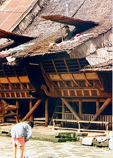
The Omo sebua is a traditional house style of the Nias people from Nias island, Indonesia. They are built only for the houses of village's chiefs. Situated in the centre of a village, omo sebua are built on massive ironwood piles and have towering roofs. Nias culture, with former frequent inter-village warfare, has made the design of omo sebua impregnable to attack. The houses' sole access is through a narrow staircase with a small trap door above. The steeply pitched roofs can reach 16 metres in height. Apart from a strong defense against enemies, omo sebua have proven earthquake resistance.
North Pagai is the smallest of the four principal Mentawai Islands off the west coast of Sumatra in Indonesia. It is south of Sipora and north of South Pagai Island.
South Pagai is one of the Mentawai Islands off the west coast of Sumatra in Indonesia. It is south of North Pagai Island. The area and population figures given for South Pagai in the box to the right are for South Pagai District alone. They exclude the south part of Sikakap District, which covers the southern part of North Pagai Island and the northern part of South Pagai Island, together with various small islands in the strait between the two.

The September 2007 Sumatra earthquakes were a series of megathrust earthquakes that struck the Sunda Trench off the coast of Sumatra, Indonesia, with three of magnitude 7 or greater. A series of tsunami bulletins was issued for the area. The most powerful of the series had a magnitude of 8.4, which makes it in the top 20 of the largest earthquakes ever recorded on a seismograph.

The April 2010 Sumatra earthquake occurred on with a moment magnitude of 7.8 and a maximum Mercalli intensity of VIII (Severe). The shock occurred near Banyak Islands, off the island of Sumatra in Indonesia. A tsunami watch was issued according to the Pacific Tsunami Warning Center in Honolulu which was later canceled. A 40 cm surge was reported in the Banyak Islands an hour after the quake, along with 62 injuries. Power outages were reported throughout the province of North Sumatra as well as in Aceh. This quake is one of the sequence of large earthquakes along the Sunda megathrust in 2000s.

The following is an alphabetical list of topics related to the Republic of Indonesia.

The 2010 Mentawai earthquake occurred with a moment magnitude of 7.8 on 25 October off the western coast of Sumatra at 21:42 local time. The earthquake occurred on the same fault that produced the 2004 Indian Ocean earthquake. It was widely felt across the provinces of Bengkulu and West Sumatra and resulted in a substantial localized tsunami that struck the Mentawai Islands.

Sikakap is a sub-district on the Indonesian island of North Pagai, in the Mentawai Islands off Sumatra. The sub-district contains both Sikakap and Matobe, while Sikakap village incorporates the hamlets of Central Sikakap, East Sikakap and Sibaibai. Overall, the total population was 3,194 as of 2016. Also part of the sub-district is the Sikakap Strait between North and South Pagai, a designated Regional Marine Conservation Area. The Strait, an area of 3,960 hectares, has a coastal length of 19.79 kilometres (12.30 mi) and is a major contributor to West Sumatra's fishing industry.

The 2016 Sumatra earthquake was a 7.8 magnitude earthquake which struck on 2 March 2016 in the Indian Ocean, approximately 800 kilometers southwest of Sumatra in Indonesia. Tsunami warnings were issued for Indonesia and Australia, but were withdrawn two hours later. There were no deaths directly related to the earthquake.
The 1907 Sumatra earthquake occurred on January 4 at 05:19:12 UTC. The estimated magnitude is 7.5–8.0 , with an epicentre close to Simeulue, off Sumatra. It triggered a widespread and damaging tsunami that caused at least 2,188 deaths. The low observed intensity compared to the size of the tsunami has led to its interpretation as a tsunami earthquake. Higher levels of shaking observed on Nias are attributed to a large aftershock, less than an hour later. The tsunami gave rise to the S'mong legend, which is credited with saving many lives during the 2004 earthquake.

On February 20, 2008, an earthquake with a moment magnitude of 7.4 struck off the coast of Sumatra at a hypocentre depth of 26 km. The earthquake had an epicenter located on the island of Simeulue, northwest from Sinabang, a small town on the island. Three people were killed and an additional 25 seriously injured as a result of the earthquake.

