
Indonesia's transport system has been shaped over time by the economic resource base of an archipelago with thousands of islands, and the distribution of its more than 200 million people concentrated mainly on a single island, Java.

Sumbawa is an Indonesian island, located in the middle of the Lesser Sunda Islands chain, with Lombok to the west, Flores to the east, and Sumba further to the southeast. Along with Lombok, it forms the province of West Nusa Tenggara, but there have been plans by the Indonesian government to split the island off into a separate province. Traditionally, the island is known as the source of sappanwood, as well as honey and sandalwood. Its savanna-like climate and vast grasslands are used to breed horses and cattle, as well as to hunt deer.
Makassar is the capital of the Indonesian province of South Sulawesi. It is the largest city in the region of Eastern Indonesia and the country's fifth-largest urban center after Jakarta, Surabaya, Bandung, and Medan. The city is located on the southwest coast of the island of Sulawesi, facing the Makassar Strait. Most of its inhabitants are Buginese people or "Bugis" followed by native Makassar people or 'Makassarese'.

East Kalimantan is a province of Indonesia. Its territory comprises the eastern portion of Borneo. It had a population of about 3.03 million at the 2010 Census, 3.42 million at the 2015 Census, and 3.766 million at the 2020 census. Its capital is the city of Samarinda.

Balikpapan is a seaport city in East Kalimantan, Indonesia. Located on the east coast of the island of Borneo, the city is the financial center of Kalimantan. Balikpapan is the city with the largest economy in Kalimantan with an estimated 2016 GDP at Rp 73.18 trillion. The city has the third busiest airport in Kalimantan after that in Banjarmasin and Pontianak, namely Sultan Aji Muhammad Sulaiman Sepinggan Airport. Port of Semayang was the second busiest seaport in East Kalimantan, after that in Samarinda.

Batam is the largest city in the province of Riau Islands, Indonesia. The city administrative area covers three main islands of Batam, Rempang, and Galang, as well as several small islands. Batam Island is the core urban and industrial zone, while both Rempang Island and Galang Island maintain their rural character and are connected to Batam Island by short bridges. Batam is an industrial boomtown, an emerging transport hub, and part of a free trade zone in the Indonesia–Malaysia–Singapore Growth Triangle, located 20 km (12 mi) off Singapore's south coast and also part of the Indonesia–Malaysia–Thailand Growth Triangle.

Sibolga is a city and a port located in the natural harbor of Sibolga Bay on the west coast of North Sumatra province, in Indonesia.
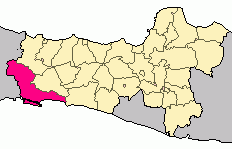
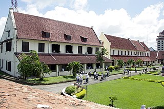
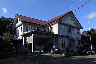
Cilacap Regency is a regency in the southwestern part of Central Java province in Indonesia. Its capital is the town of Cilacap.

North Jakarta is one of the five administrative cities which form Special Capital Region of Jakarta, Indonesia. North Jakarta is not self-governed and does not have a city council, hence it is not classified as a proper municipality. It contains the entire coastal area within the Jakarta Special District. In North Jakarta, an area at the estuary of Ciliwung river was the main port for the kingdom of Tarumanegara, which later grew to become Jakarta. Many historic sites and artefacts of Jakarta can be found in North Jakarta. Both ports of Tanjung Priok and historic Sunda Kelapa are located in the city. The city, which covers an area of 139.99 km2, had 1,645,659 inhabitants at the 2010 Census and 1,778,981 at the 2020 Census. It has its administrative centre in Tanjung Priok.

Bontang is a city on the eastern coast of the island of Borneo in Indonesia, in the province of East Kalimantan. It occupies an area of 161.88 km2 (62.50 sq mi), and the population was 140,787 at the 2010 Census, and 178,917 at the 2020 Census. It is also the third most densely populated place in the province after Balikpapan and Samarinda.

Kutai Kartanegara Regency is a regency of East Kalimantan province, Indonesia. It has a land area of 27,263.10 km2 and a water area of 4,097 km2, geographically located between 1°18′40″S and 116°31′36″E. The population of the regency was 626,286 at the 2010 Census and 729,382 at the 2020 Census. The town of Tenggarong is the capital of the regency.

West Lombok Regency is a regency of the Indonesian Province of West Nusa Tenggara. It is located on the island of Lombok and the administrative capital is the town of Gerung. The regency covers an area of 1,053.92 km2 and had a population of 599,609 at the 2010 Census and 721,481 at the 2020 Census.

East Lombok Regency is a regency of the Indonesian Province of West Nusa Tenggara. It is located on the island of Lombok, of which it comprises the eastern third ; the administrative capital is the town of Selong. The Regency covers an area of 1,605.55 km2 and had a population of 1,105,582 at the 2010 Census and 1,325,240 at the 2020 Census.

Paser Regency is a Regency (kabupaten) within East Kalimantan province in Indonesia, it is the southernmost regency of the East Kalimantan province. Its administrative centre is Tana Paser. It covers an area of 11,603.94 km2, and it had a population of 230,316 at the 2010 Census and 275,452 at the 2020 Census. Before 2007, this regency was formerly named Pasir Regency.

Penajam North Paser Regency is a regency (kabupaten) located in East Kalimantan province in Indonesia. Its administrative centre is the town of Penajam. The area which now forms Penajam North Paser was part of Paser Regency until its separation in the year 2002. It covers an area of 3,333.06 km2 and it had 142,922 inhabitants at the 2010 Census and 178,681 at the 2020 Census. Penajam North Paser Regency has the smallest area among the seven regencies in East Kalimantan province.

North Kalimantan is a province of Indonesia. It is located on the northernmost of Kalimantan, the Indonesian part of the island of Borneo. North Kalimantan borders the Malaysian states of Sabah to the north and Sarawak to the west, and by the Indonesian province of East Kalimantan to the south. Tanjung Selor serves as the capital of the province, while Tarakan is the largest city and the financial centre.

The 2018 Balikpapan oil spill was an oil spill off the coast from the city of Balikpapan, Indonesia. It was caused by a cracked pipeline linked to a Pertamina refinery in the city.
The Trans-Kalimantan Highway Southern Route, or simply the Trans-Kalimantan Highway, is a 3,901-kilometre (2,424 mi) national road that forms the backbone highway system in Kalimantan, Indonesia. It forms a part of the larger Pan-Borneo Highway network which also combines with highway networks of East Malaysia and Brunei. The combined highway network forms the entire Asian Highway Network Route AH150.
West Balikpapan is a district in the city of Balikpapan, East Kalimantan, Indonesia. The area is 37.49 km² in water and on land an area of 179.952 km² or about 35.75% of Balikpapan area. West Balikpapan is bordered by Kutai Kartanegara Regency to the North, by North Balikpapan to the North-East, by Central Balikpapan to the East-South, and Balikpapan Bay to the South-West.

