The South China Sea is a marginal sea of the Western Pacific Ocean. It is bounded in the north by South China, in the west by the Indochinese Peninsula, in the east by the islands of Taiwan and northwestern Philippines, and in the south by Borneo, eastern Sumatra and the Bangka Belitung Islands, encompassing an area of around 3,500,000 km2 (1,400,000 sq mi). It communicates with the East China Sea via the Taiwan Strait, the Philippine Sea via the Luzon Strait, the Sulu Sea via the straits around Palawan, and the Java Sea via the Karimata and Bangka Straits. The Gulf of Thailand and the Gulf of Tonkin are part of the South China Sea.

The Taiwan Strait is a 180-kilometer -wide strait separating the island of Taiwan and the Asian continent. The strait is part of the South China Sea and connects to the East China Sea to the north. The narrowest part is 130 km wide.

The Karimata Strait is a wide strait that connects the South China Sea to the Java Sea, separating the Indonesian islands of Belitung to the west and Borneo (Kalimantan) to the east. It is the widest strait between the South China Sea and the Java Sea, but its numerous islands and reefs reduce its navigability. Its weather and current is influenced by the annual southeast and northwest monsoon.

The Bangka Belitung Islands is a province of Indonesia. Situated off the southeastern coast of Sumatra, the province comprises two main land masses — the islands of Bangka and Belitung — and numerous smaller islands. Bangka Belitung is bordered by the Bangka Strait to the west, the Natuna Sea to the north, the Java Sea is to the south and the Karimata Strait to the east; the two principal islands are separated by the Gaspar Strait, within which lie lesser islands such as Lepar, Pongok and Mendanau.

The Java Sea is an extensive shallow sea on the Sunda Shelf, between the Indonesian islands of Borneo to the north, Java to the south, Sumatra to the west, and Sulawesi to the east. Karimata Strait to its northwest links it to the South China Sea. Although generally considered to be a part of the western Pacific Ocean, the Java Sea is occasionally considered to be a part of the Indian Ocean.

The Celebes Sea or Sulawesi Sea of the western Pacific Ocean is bordered on the north by the Sulu Archipelago and Sulu Sea and Mindanao Island of the Philippines, on the east by the Sangihe Islands chain, on the south by Sulawesi's Minahasa Peninsula, and the west by northern Kalimantan in Indonesia. It extends 420 miles (675 km) north-south by 520 mi (840 km) east-west and has a total surface area of 110,000 square miles (280,000 km2), to a maximum depth of 20,300 feet (6,200 m). South of the Cape Mangkalihat, the sea opens southwest through the Makassar Strait into the Java Sea.

Natuna Regency is an islands regency located in the northernmost part of the Province of Riau Islands, Indonesia. It contains at least 154 islands, of which 127 of them are reported as uninhabited. This archipelago, with a land area of 1,978.49 km2 out of a total area of 264,198.37 km2 area, This area is divided into island clusters such as the Natuna Island Cluster and the Serasan Island Cluster. However, several other islands that are not located in the two clusters are spread over a wider area. This division reflects the geographical and administrative location of the district, but there are also other small islands that are outside these two main clusters and are not always included in the grouping. Administratively, this area is divided into 17 districts (kecamatan) which function to facilitate management and services for the local community and support the development of the potential of the region which is rich in natural resources and tourism. This regency also plays an important role in maintaining Indonesia's sovereignty in the northern border area.

Bangka is an island lying east of Sumatra, Indonesia. It is administered under the province of the Bangka Belitung Islands, being one of its namesakes alongside the smaller island of Belitung across the Gaspar Strait. The 9th largest island in Indonesia, it had a population of 1,146,581 at the 2020 census; the official estimate as at mid 2023 was 1,191,300. It is the location of the provincial capital of Pangkal Pinang, and is administratively divided into four regencies and a city. The island itself and the surrounding sea suffers considerable environmental damage from its thriving tin mining industry which operates on- and offshore.

The Savu Sea is a small sea within Indonesia named for the island of Savu (Sawu) on its southern boundary. It is bounded by Savu and Raijua to the south, the islands of Rote and Timor to the east, Flores and the Alor archipelago to the north/northwest, and the island of Sumba to the west/northwest. Between these islands, it flows into the Indian Ocean to the south and west, the Flores Sea to the north, and the Banda Sea to the northeast.

The Banda Sea is one of four seas that surround the Maluku Islands of Indonesia, connected to the Pacific Ocean, but surrounded by hundreds of islands, including Timor, as well as the Halmahera and Ceram Seas. It is about 1000 km (600 mi) east to west, and about 500 km (300 mi) north to south.
Belitung is an island on the east coast of Sumatra, Indonesia in the Java Sea. It covers 4,859 km2 (1,876.1 sq mi), and had a population of 309,097 at the 2020 Census; the official estimate as at mid 2023 was 320,500. Administratively, it forms two regencies within the province of Bangka-Belitung Islands. The island is known for its pepper and for its tin. It was in the possession of the United Kingdom from 1812 until Britain ceded control of the island to the Netherlands in the Anglo-Dutch Treaty of 1824. Its main town is Tanjung Pandan. The United Nations Educational, Scientific and Cultural Organization has declared 17 tourist attractions in the Belitung Geopark as world geoparks.
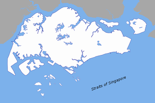
The Singapore Strait is a 113 km-long (70 mi), 19 km-wide (12 mi) strait between the Strait of Malacca in the west and the South China Sea in the east. Singapore is on the north of the channel, and the Indonesian Riau Islands are on the south. The two countries share a maritime border along the strait.

The Molucca Sea is located in the western Pacific Ocean, around the vicinity of Indonesia, specifically bordered by the Indonesian Islands of Celebes (Sulawesi) to the west, Halmahera to the east, and the Sula Islands to the south. The Molucca Sea has a total surface area of 77,000 square miles. The Molucca Sea is rich in coral and has many diving sites due to the deepness of its waters. The deepness of the water explains the reasoning behind dividing the sea into three zones, which functions to transport water from the Pacific Ocean to the shallower seas surrounding it. The deepest hollow in the Molucca Sea is the 15,780-foot (4,810-meter) Batjan basin. This region is known for its periodic experiences of earthquakes, which stems from the sea itself being a micro plate, in which the Molucca Sea is being subducted in two opposite directions: one in the direction of the Eurasian Plate to the west and the other in the direction of the Philippine Sea Plate to the east.

The Seram Sea or Ceram Sea is one of several small seas between the scattered islands of Indonesia. It is a section of the Pacific Ocean with an area of approximately 120,000 km2 (46,000 sq mi) located between Buru and Seram, which are two of the islands once called the South Moluccas. These islands are the native habitat of plants long coveted for their use as spices, such as nutmeg, cloves, and black peppercorns, and the seas surrounding them were busy shipping routes. The Seram Sea is also the habitat of several species of tropical goby and many other fish. Like many other small Indonesian seas, the Seram Sea is rocky and very tectonically active.
The East Indian Archipelago is an area designated by the International Hydrographic Organization (IHO). It encompasses twelve seas, two gulfs, and one strait in the East Indies.

The borders of the oceans are the limits of Earth's oceanic waters. The definition and number of oceans can vary depending on the adopted criteria. The principal divisions of the five oceans are the Pacific Ocean, Atlantic Ocean, Indian Ocean, Southern (Antarctic) Ocean, and Arctic Ocean. Smaller regions of the oceans are called seas, gulfs, bays, straits, and other terms. Geologically, an ocean is an area of oceanic crust covered by water.

Cape Fugui, Cape Fukwei, Fukwei Chiao, Fuguei Cape, or Fugui Cape is a cape located at the northernmost point of the island of Taiwan. It is located in Cape Fugui Park within the Shimen District in New Taipei City.

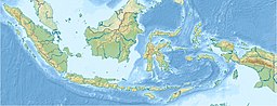
Indonesia has an Exclusive Economic Zone (EEZ) Indonesian: Zona Ekonomi Eksklusif(ZEE) which is the 6th largest EEZ in the world with an area of 6,159,032 km2 (2,378,016 sq mi). Indonesia has claimed an EEZ of 200 nautical miles (370 km) from its coastline. This causes the number of islands in the Indonesian archipelago, totaling 17,508 islands, Indonesia has the 2nd largest coastline of 99,083 km (61,542,159 miles). Indonesia position is also located on the crossing route in Southeast Asia between the Indian Ocean and the Pacific Ocean.
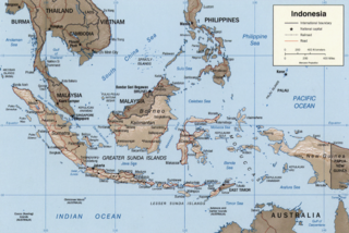
The borders of Indonesia include land and maritime borders with Malaysia, Papua New Guinea, and East Timor, as well as shared maritime boundaries with Australia, India, Palau, Philippines, Singapore, Thailand, and Vietnam.

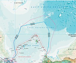
The North Natuna Sea is a shallow body of water located north of Natuna Regency. Named by the Indonesian government in July 2017, Indonesia changed the northern part of its Exclusive Economic Zone in the South China Sea to the North Natuna Sea, bordering the southern part of Vietnam's Exclusive Economic Zone. The North Natuna Sea lies between the Natuna Islands and the Natuna Sea and Cape Cà Mau south of the Mekong Delta in Vietnam.