Lombok is an island in West Nusa Tenggara province, Indonesia. It forms part of the chain of the Lesser Sunda Islands, with the Lombok Strait separating it from Bali to the west and the Alas Strait between it and Sumbawa to the east. It is roughly circular, with a "tail" to the southwest, about 70 kilometres across and a total area of about 4,607.38 square kilometres including smaller offshore islands. The provincial capital and largest city on the island is Mataram.

Sumbawa is an Indonesian island, located in the middle of the Lesser Sunda Islands chain, with Lombok to the west, Flores to the east, and Sumba further to the southeast. Along with Lombok, it forms the province of West Nusa Tenggara, but there have been plans by the Indonesian government to split the island off into a separate province. Traditionally, the island is known as the source of sappanwood, as well as honey and sandalwood. Its savanna-like climate and vast grasslands are used to breed horses and cattle, as well as to hunt deer.

The Sunda Strait is the strait between the Indonesian islands of Java and Sumatra. It connects the Java Sea with the Indian Ocean.

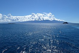
The Lombok Strait, is a strait of the Bali Sea connecting to the Indian Ocean, and is located between the islands of Bali and Lombok in Indonesia. The Gili Islands are on the Lombok side.

The Australasian realm is one of eight biogeographic realms that is coincident with, but not the same as, the geographical region of Australasia. The realm includes Australia, the island of New Guinea, and the eastern part of the Indonesian archipelago, including the island of Sulawesi, the Moluccas, and the islands of Lombok, Sumbawa, Sumba, Flores, and Timor, often known as the Lesser Sundas.

The Wallace line or Wallace's line is a faunal boundary line drawn in 1859 by the British naturalist Alfred Russel Wallace and named by the English biologist T.H. Huxley.

West Nusa Tenggara is a province of Indonesia. It comprises the western portion of the Lesser Sunda Islands, with the exception of Bali which is its own province. The area of this province is 19,675.89 km2 (7,596.90 sq mi) which consists of two main islands, namely Lombok Island and Sumbawa Island as well as several other small islands. The two largest islands in this province are the smaller but much more populated Lombok in the west and the much larger in area but much less densely populated Sumbawa island in the east. Mataram, on Lombok, is the capital and largest city of the province. It shares maritime borders with Bali to the west and East Nusa Tenggara to the east.

Mount Rinjani is an active volcano in Indonesia on the island of Lombok. Administratively the mountain is in the Regency of North Lombok, West Nusa Tenggara. It rises to 3,726 metres (12,224 ft), making it the second highest volcano in Indonesia. It is also the highest point in the Indonesian province of West Nusa Tenggara. Adjacent to the volcano is a 6-by-8.5-kilometre caldera, which is filled partially by the crater lake known as Segara Anak or Anak Laut, due to the color of its water, as blue as the sea (laut). This lake is approximately 2,000 metres (6,600 ft) above sea level and estimated to be about 200 metres (660 ft) deep; the caldera also contains hot springs. The lake and mountain are sacred to the Sasak people and Hindus, and are the site of religious rituals. UNESCO made Mount Rinjani Caldera a part of the Global Geoparks Network in April 2018.

The Sasak language is spoken by the Sasak ethnic group, which make up the majority of the population of Lombok, an island in the West Nusa Tenggara province of Indonesia. It is closely related to the Balinese and Sumbawa languages spoken on adjacent islands, and is part of the Austronesian language family. Sasak has no official status; the national language, Indonesian, is the official and literary language in areas where Sasak is spoken.

The Sape Strait or Sapie Strait is a strait connecting the Flores Sea to the Sumba Strait. It separates the islands of Sumbawa and Komodo. It joins the Indonesian provinces of West Nusa Tenggara and East Nusa Tenggara.

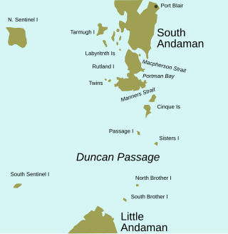
Duncan Passage is a strait in the Bay of Bengal. It is about 48 km (30 mi) wide; it separates Rutland Island to the north, and Little Andaman to the south. West of Duncan Passage is the Bay of Bengal; east is the Andaman Sea. It lies within the exclusive economic zone of India protected by the integrated tri-services Andaman and Nicobar Command of Indian Military.

West Lombok Regency is a regency of the Indonesian Province of West Nusa Tenggara. It is located on the island of Lombok and the administrative capital is the town of Gerung. The regency covers a land area of 922.91 km2 and had a population of 599,609 at the 2010 census and 721,481 at the 2020 census; the official estimate as at mid 2023 was 753,641.

East Lombok Regency is a regency of the Indonesian Province of West Nusa Tenggara. It is located on the island of Lombok, of which it comprises the eastern third ; the administrative capital is the town of Selong. The Regency covers an area of 1,605.55 km2 and had a population of 1,105,582 at the 2010 Census and 1,325,240 at the 2020 Census; the official estimate as at mid 2023 was 1,404,343.

Central Lombok Regency is a regency of the Indonesian Province of West Nusa Tenggara. It is located on the island of Lombok and the capital is Praya. It covers an area of 1,208.39 km2, and had a population of 859,309 at the 2010 census and 1,034,859 at the 2020 census; the official estimate as at mid 2023 was 1,099,211.

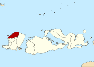
North Lombok Regency is a regency of the Indonesian Province of West Nusa Tenggara. It is located in the northwest of the island of Lombok and includes the offshore Gili Islands. The capital is Tanjung situated on the northwest coast of the island. The regency covers an area of 809.53 km2 and had a population of 200,072 at the 2010 Census and 247,400 at the 2020 Census; the official estimate as at mid 2023 was 265,500.

The Lesser Sundas deciduous forests is a tropical dry forest ecoregion in Indonesia. The ecoregion includes the islands of Lombok, Sumbawa, Komodo, Flores, and Alor, along with the many adjacent smaller islands.

The Lesser Sunda Islands, now known as Nusa Tenggara Islands, are an archipelago in Indonesian archipelago. Most of the Lesser Sunda Islands are located within the Wallacea region, except for the Bali province which is west of the Wallace Line and is within the Sunda Shelf. Together with the Greater Sunda Islands to the west they make up the Sunda Islands. The islands are part of a volcanic arc, the Sunda Arc, formed by subduction along the Sunda Trench in the Java Sea. In 1930 the population was 3,460,059; today slightly over 15.5 million people live on the islands. Etymologically, Nusa Tenggara means "Southeast Islands" from the words of nusa which means 'island' from Old Javanese language and tenggara means 'southeast'.

The Australasian Mediterranean Sea is a mediterranean sea located in the area between Southeast Asia and Australasia. It connects the Indian and Pacific oceans. It has a maximum depth of 7,440 m and a surface area of 9.08 mil. km².
Flores Back Arc Thrust Fault is a major system of west–east trending thrust faults that extend eastwards from west of Lombok just south of where Sunda Shelf ends at Bali Sea, towards the islands of Sumbawa, Flores, and Alor, with a total length of at least 800 km., entering the Weber Basin and Aru Basin adjacent Sahul Shelf of the Australian Plate. The thrust faults are south-dipping and lie within the back arc region of the Sunda-Banda Arc, which is related to the ongoing subduction of the Australian Plate beneath the Sunda and Banda Sea Plates. The thrust fault system developed as a result of the onset of continental collision as continental crust of the Australian Plate reached the Sunda Trench. The eastern part of the fault system is also known as the Wetar thrust. Above the main thrust fault are a series of imbricate (overlapping) thrust faults. These imbricate thrust faults are shallower in depth than the main Flores thrust. Although the exact thrust faults have not been established, these faults were thought to be responsible for the 2018 Lombok earthquakes.


