
Sumbawa is an Indonesian island, located in the middle of the Lesser Sunda Islands chain, with Lombok to the west, Flores to the east, and Sumba further to the southeast. Along with Lombok, it forms the province of West Nusa Tenggara, but there have been plans by the Indonesian government to split the island off into a separate province. Traditionally, the island is known as the source of sappanwood, as well as honey and sandalwood. Its savanna-like climate and vast grasslands are used to breed horses and cattle, as well as to hunt deer.

Mount Tambora, or Tomboro, is an active stratovolcano in West Nusa Tenggara, Indonesia. Located on Sumbawa in the Lesser Sunda Islands, it was formed by the active subduction zones beneath it. Before 1815, its elevation reached more than 4,300 metres high, making it one of the tallest peaks in the Indonesian archipelago.

Alor is the largest island in the Alor Archipelago and is one of the 92 officially listed outlying islands of Indonesia. It is located at the eastern end of the Lesser Sunda Islands chain that runs through southeastern Indonesia, which from the west include such islands as Bali, Lombok, Sumbawa, Komodo, and Flores.

Minangkabau International Airport is an airport serving the province of West Sumatra on the island of Sumatra, Indonesia. It is located at Ketaping, Padang Pariaman Regency which is about 23 km north-west of Padang city center. The airport became operational in July 2005, replacing the old Tabing Airport in Padang. The airport is named after the Minangkabau ethnic group who inhabit the region.

Sabang is a city in Aceh province, Indonesia consisting entirely of Weh Island and several smaller islands off the northern tip of Sumatra. The administrative centre of the city is located 17 kilometres (11 mi) north of Banda Aceh. The city covers an area of 122.13 square kilometres (47.15 sq mi) and had a population of 43,391 in the 2020 census although that total was subsequently adjusted to 41,197; the official estimate as at mid 2023 was 43,527. Sabang is known as the northernmost and westernmost city of Indonesia. It also has by far the smallest population of any city in Indonesia.

Tanjungbalai, also colloquially written as Tanjung Balai, is a city in North Sumatra province, Indonesia, on the estuary of the Asahan River. It has an area of 60.52 square kilometers (23.37 sq mi) and the sixth largest kota (urban) population in North Sumatra with 154,445 inhabitants in the 2010 census and 176,027 at the 2020 Census; the official estimate as at mid 2023 was 183,170 - comprising 92,715 males and 90,455 females. The town has a ferry terminal with services to Port Klang, Malaysia, and the city-island of Singapore.

Teluk Cenderawasih National Park is the largest marine national park of Indonesia, located in Cenderawasih Bay, south-east of Bird's Head Peninsula. It includes the islands of Mioswaar, Nusrowi Island, Roon, Rumberpon, Anggrameos and Yoop. The park protects a rich marine ecosystem, with over 150 recorded coral species, for which it is considered a potential World Heritage Site.
Sea World Ancol, also known as Sea World Jakarta or Sea World Indonesia, is a marine aquarium attraction in North Jakarta, Jakarta, Indonesia. It is part of the Ancol Dreamland complex, and consists of a main tank, a shark tank, and various other tanks, including a turtle exhibit. The main tank is one of the largest aquariums in Southeast Asia. Despite its name, it is completely unaffiliated with the US-based SeaWorld Parks & Entertainment and their chain of theme parks in the United States.

Merah Putih Bridge is a cable stayed bridge located in Ambon city, Maluku, Indonesia. The bridge spans over Ambon Bay in Ambon Island, connecting Rumah Tiga village (Poka) in Sirimau sub-district on the north side, with Hative Kecil/Galala village in Teluk Ambon sub-district on the south side. This bridge is the longest bridge in the eastern region of Indonesia; it is the landmark of the city.
Batam Center Ferry Terminal is an international ferry terminal located in Teluk Tering, Batam, Riau Islands, Indonesia. The terminal mostly serves international routes to Singapore and Malaysia. It is located north of governmental buildings of Batam and landmarks such as the Grand Mosque of Batam and Engku Putri Fountain.
The 2020 Liga 1, also known as Shopee Liga 1 for sponsorship reasons, was the 4th season of Liga 1 under its current name and the 11th season of the top-flight Indonesian professional league for association football clubs since its establishment in 2008. The season started on 29 February 2020 and was suspended on 16 March 2020 due to the COVID-19 pandemic. The season was abandoned and declared void on 20 January 2021.

Andi Oddang Makka was an Indonesian military officer and politician who became the governor of South Sulawesi from 1978 to 1983.

Ziva Magnolya Muskitta is an Indonesian singer. She is best known for the third place finalist on the tenth season of Indonesian Idol, broadcast by the national television channels RCTI in 2019 - 2020.
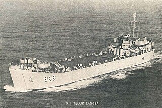
USS Solano County (LST-1128) was a LST-542-class tank landing ship in the United States Navy during World War II. She was transferred to the Indonesian Navy as KRI Teluk Langsa.

KRI Teluk Hading (538) was a Frosch-class landing ship operated the Indonesian Navy. The ship was former Cottbus of the Volksmarine.

Central Papua, officially the Central Papua Province is an Indonesian province located in the central region of Western New Guinea. It was formally established on 11 November 2022 from the former eight western regencies of the province of Papua. It covers an area of 61,072.91 km2 and had an officially estimated population of 1,452,810 in mid 2023. It is bordered by the Indonesian provinces of West Papua to the west, the province of Papua to the north and northeast, by Highland Papua to the east, and by South Papua to the southeast. The administrative capital is located in Wanggar District in Nabire Regency, although Timika is a larger town.

Southwest Papua is the 38th province of Indonesia to be created, and was split off from West Papua on 8 December 2022. Despite being named southwest, it is a misnomer and this province is actually located in the northwest edge of Papua. The province comprises the Greater Sorong area which consists of Sorong City, Sorong Regency, South Sorong Regency, Maybrat Regency, Tambrauw Regency, and Raja Ampat Regency. The Bill (RUU) on the Establishment of the Southwest Papua Province was passed into law and therefore it became the 38th province in Indonesia with effect from 8 December 2022.

