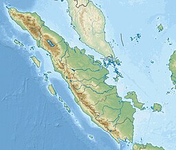
Sumatra is one of the Sunda Islands of western Indonesia. It is the largest island that is fully within Indonesian territory, as well as the sixth-largest island in the world at 475,807.63 km2 (182,812 mi.2), including adjacent islands such as the Simeulue, Nias, Mentawai, Enggano, Riau Islands, Bangka Belitung and Krakatoa archipelago.

The Karimata Strait is a wide strait that connects the South China Sea to the Java Sea, separating the Indonesian islands of Belitung to the west and Borneo (Kalimantan) to the east. It is the widest strait between the South China Sea and the Java Sea, but its numerous islands and reefs reduce its navigability. Its weather and current is influenced by the annual southeast and northwest monsoon.

Srivijaya was a Buddhist thalassocratic empire based on the island of Sumatra, which influenced much of Southeast Asia. Srivijaya was an important centre for the expansion of Buddhism from the 7th to the 12th century AD. Srivijaya was the first polity to dominate much of western Maritime Southeast Asia. Due to its location, the Srivijaya developed complex technology utilizing maritime resources. In addition, its economy became progressively reliant on the booming trade in the region, thus transforming it into a prestige goods-based economy.

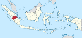
South Sumatra is a province of Indonesia, located on the southeast of the island of Sumatra, The province is 91,592.43 km2 (35,364 sq mi) and has a population of 8,467,432 at the 2020 Census; the official estimate as at mid 2022 was 8,657,008. The capital of the province is the city of Palembang. The province borders the provinces of Jambi to the north, Bengkulu to the west and Lampung to the south. The Bangka Strait in the east separates South Sumatra and the island of Bangka, which is part of the Bangka Belitung Islands province. The province is rich in natural resources, such as petroleum, natural gas and coal. The province is inhabited by many different ethnic groups, with Palembangese being largest ethnic group. Most speak the Palembang language, which is mutually intelligible to both Indonesian and local Palembang Malay. Other ethnic groups include the Javanese, Sundanese, Minangkabau and Chinese. Most are concentrated in urban areas and are largely immigrants from other parts of Indonesia.
Jambi is a province of Indonesia. It is located on the east coast of central Sumatra and spans to the Barisan Mountains in the west. Its capital and largest city is Jambi. The province has a land area of 49,026.58 km2, and a sea area of 3,274.95 km2. It had a population of 3,092,265 according to the 2010 census and 3,548,228 according to the 2020 census. The official estimate as at mid 2022 was 3,631,136.

The Orang Laut are several seafaring ethnic groups and tribes living around Singapore, peninsular Malaysia and the Indonesian Riau Islands. The Orang Laut are commonly identified as the Orang Seletar from the Straits of Johor, but the term may also refer to any Malayic-speaking people living on coastal islands, including those of Mergui Archipelago islands of Myanmar and Thailand, commonly known as Moken.
Jambi is a Malayic language spoken in Jambi province, Indonesia. It is closely related to Palembang Malay in neighbouring South Sumatra, Riau Malay in Riau Province and the surrounding islands, and Bengkulu Malay in Bengkulu Province.
Madura Strait is a stretch of water that separates the Indonesian islands of Java and Madura, in the province of East Java. The islands of Kambing, Giliraja, Genteng, and Ketapang lie in the Strait. The Suramadu Bridge, the longest in Indonesia, spans the strait between Surabaya on Java and Bangkalan on Madura.

Singkep is an island in the Lingga Archipelago in Indonesia. Its area is 757 square kilometres (292 sq mi). It is separated from the east coast of Sumatra by the Berhala Strait. It is surrounded by islands Posik to the west, I. Serak to the SW, I. Lalang to the South, and I. Selayar of Riau Islands between Lingga and Singkep.
Berhala island is an island off Sumatra in Indonesia with an area of about 2.5 km2. It is located in the Berhala Strait between Jambi and Singkep.
The Duano' are an indigenous people of Malaysia and Indonesia and can be found in islands along the northeastern region of Sumatra, Indonesia where most Duano' people have traditionally lived. They are one of the Proto-Malay group of cultures. Due to their nomadic boat lifestyle, based almost exclusively on fishing and collecting shellfish and crustaceans by using mud-boards, Duano' people are often categorized as Orang Laut, a group that includes the Urak Lawoi’ people and Moken people of the northern region of the Malacca Strait and the Andaman Sea. Although there are similarities in their way of life, they are a separate ethnic group. Citing their own language, culture, identity, and economic complexities, they deny being Orang Laut.
Berhala Island may refer to:

The following is an alphabetical list of topics related to the Republic of Indonesia.

The Sultanate of Jambi was a region ruled by a sultan in northern Sumatra. The Dutch conquered the sultanate and killed the sultan in 1904. The sultanate has since been restored in recent years. The original sultanate was centered in the modern-day province of Jambi in Indonesia.

The Natuna Sea is an extensive shallow sea located around the Natuna Regency, extending south of the Riau Islands, east of the Lingga Regency and west of Borneo, to the Bangka Belitung Islands. The islands of the Badas and Tambelan Archipelago are located at its center. Mostly located within Indonesian territorial waters, it is the southernmost portion of the South China Sea, and geologically part of Sunda Shelf. It communicates with the Java Sea to its southeast via the Karimata and Gaspar Strait east and west of Belitung, and with the Strait of Malacca to the west via the Berhala and Singapore Strait.
Berhala island is island of Sumatra in Indonesia about 0.36 km2.
The Teluk Bintuni class, Indonesian designation AT-117M is a class of tank landing ships that is being built indigenously for the Indonesian Navy by various Indonesian local shipyards. It was announced that the Indonesian Navy intends to acquire a total of twelve vessels of the same class with some modifications from the lead ship to improve ship's capability.