Pitt Strait (Indonesia)

Last updated
Pitt Strait
Karta ID RajaAmpat Isl.PNG
Indonesia Western New Guinea location map.png
Red pog.svg
Pitt Strait
Coordinates 00°55′00″S130°45′00″E / 0.91667°S 130.75000°E / -0.91667; 130.75000
Type strait
Native nameSelat Sagewin (Indonesian)
Basin  countries Indonesia
References Straat Sagewin: Indonesia National Geospatial-Intelligence Agency, Bethesda, MD, USA

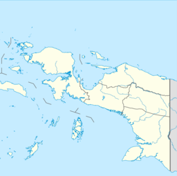
Pitt Strait (Indonesia) (a.k.a. Pitt's Strait, Sagewin Strait), [1] falls within the waters of the Indonesian province of Southwest Papua. The strait separates the Raja Ampat islands of Batanta and Salawati and links the Ceram Sea to the Pacific Ocean. [2] [3] To its west lies Dampier Strait, which separates Batanta island from Waigeo island. [3] [4] The Sagewin Strait name refers to Sagewin Island, which lies at the south east side of Pitt Strait, close to Salawati.

Contents

History

In 1759 Captain William Wilson sailing in the East Indiaman Pitt navigated these waters and named the channel between Batanta and Salawati Pitt Strait, after his vessel, or equally, her namesake. [3] He also named the two islands King George's Island and Prince of Wales's Island, [5] but these names did not prove as durable as that of the strait.

The area of the Dampier Strait and Pitt Strait are a Marine Protected Area for cetaceans. [6]

Citations

  1. Andaya (1993), p. 229.
  2. United States Hydrographic Office (1916), p. 272.
  3. 1 2 3 Moore (2003), p. 87.
  4. United States Hydrographic Office (1916), pp. 266–268.
  5. Naval Chronicle (Jul-Dec 1805), Vol. 14, p.140.
  6. Hoyt (2013), p. 309.

Related Research Articles

<span class="mw-page-title-main">Karimata Strait</span> Waterway in Indonesia between the islands of Belitung and Borneo

The Karimata Strait is a wide strait that connects the South China Sea to the Java Sea, separating the Indonesian islands of Belitung to the west and Borneo (Kalimantan) to the east. It is the widest strait between the South China Sea and the Java Sea, but its numerous islands and reefs reduce its navigability. Its weather and current is influenced by the annual southeast and northwest monsoon.

<span class="mw-page-title-main">Whale watching</span> Viewing cetaceans in their habitats

Whale watching is the practice of observing whales and dolphins (cetaceans) in their natural habitat. Whale watching is mostly a recreational activity, but it can also serve scientific and/or educational purposes. A study prepared for International Fund for Animal Welfare in 2009 estimated that 13 million people went whale watching globally in 2008. Whale watching generates $2.1 billion per annum in tourism revenue worldwide, employing around 13,000 workers. The size and rapid growth of the industry has led to complex and continuing debates with the whaling industry about the best use of whales as a natural resource.

<span class="mw-page-title-main">Banda Sea</span> A sea between Sulawesi and Maluku

The Banda Sea is one of four seas that surround the Maluku Islands of Indonesia, connected to the Pacific Ocean, but surrounded by hundreds of islands, including Timor, as well as the Halmahera and Ceram Seas. It is about 1000 km (600 mi) east to west, and about 500 km (300 mi) north to south.

<span class="mw-page-title-main">Singapore Strait</span> Strait between Indonesia, Malaysia and Singapore

The Singapore Strait is a 113 km-long (70 mi), 19 km-wide (12 mi) strait between the Strait of Malacca in the west and the South China Sea in the east. Singapore is on the north of the channel, and the Indonesian Riau Islands are on the south. The two countries share a maritime border along the strait.

<span class="mw-page-title-main">Jaco Island</span> Uninhabited island in East Timor

Jaco Island is an uninhabited island in East Timor, a country occupying the eastern end of the island of Timor in the Lesser Sunda Islands in Southeast Asia. It lies off the eastern tip with Cape Cutcha of the island of Timor.

<span class="mw-page-title-main">Waigeo</span> Island in Indonesia

Waigeo is an island in Southwest Papua province of eastern Indonesia. The island is also known as Amberi, or Waigiu. It is the largest of the four main islands in the Raja Ampat Islands archipelago, between Halmahera and about 65 kilometres to the north-west coast of New Guinea. The Dampier Strait separates it from Batanta, and the Bougainville Strait from the Kawe Islands to its north-west. The "inner sea" that nearly cleaves the island in two is Mayalibit Bay, also known as the Majoli Gulf.

<span class="mw-page-title-main">Ombai Strait</span> Strait in Southeast Asia

Ombai Strait is an international strait in Southeast Asia. It separates the Alor Archipelago from the islands of Wetar, Atauro, and Timor in the Lesser Sunda Islands. The strait is also the western portion of a pair of international straits, the other one being Wetar Strait; the two straits combine to link the Pacific Ocean with the Indian Ocean.

<span class="mw-page-title-main">Wetar Strait</span> Strait in Southeast Asia

Wetar Strait is an international strait in Southeast Asia. It separates the island of Wetar from the eastern part of the island of Timor. The strait is also the eastern portion of a pair of international straits, the other one being Ombai Strait; the two straits combine to link the Indian Ocean with the Pacific Ocean.

<span class="mw-page-title-main">Bird's Head Peninsula</span> Peninsula in Indonesia

The Bird's Head Peninsula or Doberai Peninsula, is a large peninsula that makes up the northwest portion of the island of New Guinea, comprising the Indonesian provinces of Southwest Papua and West Papua. It is often referred to as The Vogelkop, and is so named because its shape looks like a bird's head on the island of New Guinea. The peninsula at the opposite end of the island is called the Bird's Tail Peninsula. The peninsula just to the south is called the Bomberai Peninsula.

<span class="mw-page-title-main">Raja Ampat Islands</span> Archipelago in West Papua, Indonesia

Raja Ampat, or the Four Kings, is an archipelago located off the northwest tip of Bird's Head Peninsula on the island of New Guinea, in Indonesia's Southwest Papua province. It comprises over 1,500 small islands, cays, and shoals surrounding the four main islands of Misool, Salawati, Batanta, and Waigeo, and the smaller island of Kofiau.

<span class="mw-page-title-main">Misool</span> Island in Indonesia

Misool, formerly spelled Mysol or Misol, is one of the four major islands in the Raja Ampat Islands in Southwest Papua, Indonesia. Its area is 2,034 km2. The highest point is 561 m and the main towns are Waigama, located on the island's northwest coast, and Lilinta on the island's southeast coast.

<span class="mw-page-title-main">Salawati</span> Island in Indonesia

Salawati is one of the four major islands in the Raja Ampat Islands in Southwest Papua, Indonesia. Its area is 1,623 km2. Salawati is separated from New Guinea to the southeast by the Sele Strait, and from Batanta to the north by the Pitt Strait.

<span class="mw-page-title-main">Batanta</span>

Batanta is one of the four major islands in the Raja Ampat Islands in Southwest Papua province, Indonesia. Its area is 453 km² and its highest point is 1184 m. The Pitt Strait separates it from Salawati, while the Dampier Strait separates it from Waigeo.

<span class="mw-page-title-main">Dampier Strait (Indonesia)</span> Strait in Indonesia

Dampier Strait in the Indonesian province of Southwest Papua is a strait that separates the Raja Ampat islands of Waigeo and Batanta. It is named after British navigator William Dampier.

<span class="mw-page-title-main">Backstairs Passage</span> Strait in South Australia

The Backstairs Passage is a strait in South Australia lying between Fleurieu Peninsula on the Australian mainland and Dudley Peninsula on the eastern end of Kangaroo Island. The western edge of the passage is a line from Cape Jervis on Fleurieu Peninsula to Kangaroo Head on Kangaroo Island. The Pages, a group of islets, lie in the eastern entrance to the strait. About 14 km wide at its narrowest, it was formed by the rising sea around 13,000 years ago, at the end of the Pleistocene era, when it submerged the land connecting what is now Kangaroo Island with the Fleurieu Peninsula. Backstairs Passage was named by Matthew Flinders whilst he and his crew on HMS Investigator were exploring and mapping the coastline of South Australia in 1802.

<span class="mw-page-title-main">Raja Ampat Regency</span> Regency in Southwest Papua, Indonesia

Raja Ampat Regency is a regency of Southwest Papua Province of Indonesia. The regency, which was formed by separating the archipelago from Sorong Regency, based on the Law 26 of 2002, was inaugurated on 12 April 2003. It consists of a number of groups of islands situated off the north-west end of West Papua; the four main islands from south to north are Misool, Salawati, Batanta, and Waigeo. At present, the regency covers a land area of 7,559.60 km2, with a total area stated as 67,379.61 km2. It had a population of 42,508 at the 2010 Census and 64,141 at the 2020 Census; the official estimate as at mid 2022 was 66,839. The principal town lies at Waisai on Waigeo Island.

<i>Pondichéry</i> (1754 ship)

Pondicherry was a French East Indiaman, launched in December 1754, that the Royal Navy captured in 1756, early in the Seven Years' War with France. She was then sold and her new owners, who renamed her Pitt, proceeded to charter her to the British East India Company (EIC), for three voyages. During her first voyage she engaged a French warship, and then went on to chart a new route, Pitt's Passage, through the East Indies on the way to China. The EIC found this new route of the utmost importance as it was faster than their existing route, and was navigable in all seasons. After her return from her third voyage Pitt disappears from readily available online sources.

Sagewin, or Sagawin, is a small uninhabited island in the Raja Ampat Archipelago of eastern Indonesia. It lies off the north-western tip of the larger island of Salawati and is surrounded by the waters of the Pitt Strait, which separates Salawati from the island of Batanta. The island of Sagewin is 7.3 kilometres in length, and has a mean elevation of 20 meters.

<span class="mw-page-title-main">Warir</span>

Warir, or Waiji, is an island in the Raja Ampat Archipelago of Southwest Papua, Indonesia. Situated in the Sele Strait, it lies off the eastern coast of the larger island of Salawati. It has an area of 42.8 square kilometres (16.5 sq mi), its length north to south is about 9 kilometres (5.6 mi), and its east-west extent varies between 2.5 kilometres (1.6 mi) and 6 kilometres (3.7 mi). It is relatively low-lying, with no point exceeding an elevation of 80 metres (260 ft). Its interior is forested, with mangroves fringing the coastal areas, and some agricultural land in the north. The small settlement of Wamega is situated on the north-west coast.

References