
Lombok, is an island in West Nusa Tenggara province, Indonesia. It forms part of the chain of the Lesser Sunda Islands, with the Lombok Strait separating it from Bali to the west and the Alas Strait between it and Sumbawa to the east. It is roughly circular, with a "tail" to the southwest, about 70 kilometres across and a total area of about 4,607.38 square kilometres including smaller offshore islands. The provincial capital and largest city on the island is Mataram.

Sumbawa, is an Indonesian island, located in the middle of the Lesser Sunda Islands chain, with Lombok to the west, Flores to the east, and Sumba further to the southeast. Along with Lombok, it forms the province of West Nusa Tenggara, but there have been plans by the Indonesian government to split the island off into a separate province. Traditionally, the island is known as the source of sappanwood, as well as honey and sandalwood. Its savanna-like climate and vast grasslands are used to breed horses and cattle, as well as to hunt deer.

West Nusa Tenggara is a province of Indonesia. It comprises the western portion of the Lesser Sunda Islands, with the exception of Bali which is its own province. The area of this province is 19,675.89 km2 (7,596.90 sq mi) which consists of two main islands, namely Lombok Island and Sumbawa Island as well as several other small islands. The two largest islands in this province are the smaller but much more populated Lombok in the west and the much larger in area but much less densely populated Sumbawa island in the east. Mataram, on Lombok, is the capital and largest city of the province. It shares maritime borders with Bali to the west and East Nusa Tenggara to the east.

Komodo National Park is a national park in Indonesia located within the Lesser Sunda Islands in the border region between the provinces of East Nusa Tenggara and West Nusa Tenggara. The park includes the three larger islands Komodo, Padar and Rinca, and 26 smaller ones, with a total area of 1,733 km2. The national park was founded in 1980 to protect the Komodo dragon, the world's largest lizard. Later it was dedicated to protecting other species, including marine species. In 1991 the national park was declared a UNESCO World Heritage Site and a Man and Biosphere Reserve. It is considered one of the world's 25 biodiversity hotspots.

Komodo is one of the 17,508 islands that comprise the Republic of Indonesia. It is particularly notable as the habitat of the Komodo dragon, the largest lizard on Earth, which is named after the island. Komodo Island has a surface area of 291 square kilometres, and had a human population of about 1,800 in 2020.

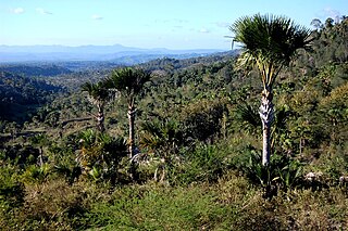
Rinca is a small island near Komodo and Flores island, East Nusa Tenggara, Indonesia, within the West Manggarai Regency. It is one of the three largest islands included in Komodo National Park. The island is famous for Komodo dragons, giant lizards that can measure up to 3 metres (9.8 ft) long. Rinca is also populated with many other species such as wild pigs, buffalos and many birds.
Sail Indonesia is a series of sailing and other events for yachts conducted each year in Indonesia. The events are organised by Yayasan Cinta Bahari Indonesia (YCBI) and supported by the high-profile tourist destinations to international yachtsmen and women with a view to expanding the tourism potential and raising awareness of the region as well as introducing visitors to natural and cultural features of the Indonesian archipelago that they might otherwise not visit.

West Manggarai Regency is one of the eight regencies which comprise the island of Flores, located in the province of East Nusa Tenggara in Indonesia. The Regency was created on 25 February 2003 by the separation off of the western districts from Manggarai Regency. It covers a land area of 3,141.47 km2, and had a population of 221,703 at the 2010 census, rising to 251,689 at the 2015 Intermediate census and to 256,317 at the 2020 census. The official estimate as at mid 2023 was 278,184. The regency's capital is the town of Labuan Bajo.

West Lombok Regency is a regency of the Indonesian Province of West Nusa Tenggara. It is located on the island of Lombok and the administrative capital is the town of Gerung. The regency covers a land area of 922.91 km2 and had a population of 599,609 at the 2010 census and 721,481 at the 2020 census; the official estimate as at mid 2023 was 753,641.

East Lombok Regency is a regency of the Indonesian Province of West Nusa Tenggara. It is located on the island of Lombok, of which it comprises the eastern third ; the administrative capital is the town of Selong. The Regency covers an area of 1,605.55 km2 and had a population of 1,105,582 at the 2010 Census and 1,325,240 at the 2020 Census; the official estimate as at mid 2023 was 1,404,343.

Sumbawa Regency is a Regency (Kabupaten) of the Indonesian Province of West Nusa Tenggara. It is located on the island of Sumbawa and covers an area of 6,643.99 km2, following the separation on 18 December 2003 of what were until then its westernmost five districts to form the newly created West Sumbawa Regency. It includes the substantial island of Moyo, lying off the north coast of Sumbawa. The population of the Regency at the 2010 Census was 415,789, which rose at the 2020 Census to 509,753; the official estimate as at mid 2023 was 529,487. The capital is the town of Sumbawa Besar on the north coast of Sumbawa Island.

West Sumbawa Regency is a Regency (Kabupaten) of the Indonesian Province of West Nusa Tenggara. It is located on the island of Sumbawa and has an area of 1,743.58 km2. The regency was created on 18 December 2003 from what were at that time the westernmost five districts (kecamatan) of Sumbawa Regency. The population at the 2010 Census was 114,754, and at the 2020 Census was 145,798; the official estimate as at mid 2023 was 152,950 comprising 77,030 males and 75,920 females. The capital is the town of Taliwang.

The Lesser Sundas deciduous forests is a tropical dry forest ecoregion in Indonesia. The ecoregion includes the islands of Lombok, Sumbawa, Komodo, Flores, and Alor, along with the many adjacent smaller islands.
The Timor and Wetar deciduous forests is a tropical dry forest ecoregion in Indonesia and East Timor. The ecoregion includes the islands of Timor, Wetar, Rote, Savu, and adjacent smaller islands.

Labuan Bajo is a fishing town located at the western end of the large island of Flores in the East Nusa Tenggara province of Indonesia. It is in Komodo District. It is the capital of the West Manggarai Regency, one of the eight regencies on Flores Island.

Se'i or sei is an Indonesian smoked meat from Kupang, Timor island, East Nusa Tenggara, Indonesia. Se'i may be derived from a variety of meats, with pork, beef or game animals such as venison as common offerings. Today, the most popular se'i meat is pork.
On 29 September 1986, thanks to a decree by the Minister of Environment, the ‘Moyo Island Hunting Park’ was established. It is a Natural Reserve covering 22,537.90 hectares, currently managed by the Conservation Bureau of West Nusa Tenggara. This area is home to long-tail macaques, wild bovines, wild pigs, deer and 21 bat species, including flying foxes. Bird-watching enthusiasts can observe 86 species of birds, 2 of them endangered: the yellow-headed parrot and the Tanimbar megapode which is endemic to Indonesia. It nests in large sandy heaps, litter, and other debris, where the heat generated by the decomposition of the organic material serves to incubate the eggs. Inside the Park there are also a few waterfalls, the biggest one is about 2 hours from Labuan Aji village, and the others are within easy reach, within 15 minutes walking distance, in the forest where there are colorful butterflies. Most of the east and west coasts and the entire south coast of Moyo Island have been declared Marine Park. Pristine coral reefs and all their inhabitants are now protected from fishing and pollution.
Mules Island, also known as Nuca Molas, is an island in the Savu Sea. The island is administered as part of Manggarai Regency in East Nusa Tenggara Province of Indonesia.
Bungin Island is located in Alas District, Sumbawa Regency, West Nusa Tenggara in Indonesia. The island is situated within Bali Sea, 70 kilometers west of the center of Sumbawa Besar district. The island is administratively one of the villages in the district. The island is mostly inhabited by the Bajo people from South Sulawesi, who arrived here more than 200 years ago. During that time they built up with material from the seabed what had been a sandy shoal of an estimated 400 square metres (4,300 sq ft) into an area of around 8.5 hectares where about 3,400 people live, making Pulau Bungin among the densest-populated islands in the world) in pile dwellings shored up with harvested coral stone. Goats are kept on land, and fish are harvested from the surrounding waters with harpoon guns. The island is connected by a causeway to the mainland of the regency. The island is.


