Ranu Pani

Last updated

Lake Pani
Ranu Pani (Javanese)
Danau Pani (Indonesian)
Frost in Ranu Pani on 4 August 2018 by Susanto Tan.jpg
Light Snow of Ranu Pani
Indonesia Java relief location map.png
Red pog.svg
Lake Pani
Location Bromo Tengger Semeru National Park, East Java
Coordinates 8°00′43″S112°56′49″E / 8.01194°S 112.94694°E / -8.01194; 112.94694
Type Volcanic
Primary inflows Precipitation only
Basin  countriesIndonesia
Surface area0.75 ha (1.9 acres)
Average depth7 m (23 ft)
Surface elevation2,114 m (6,900 ft)
References [1]

Ranu Pani or Ranupani is a volcanic lake in Ranu Pani Village, Senduro District, Lumajang Regency, East Java. Ranu Pani is part of the Bromo Tengger Semeru National Park (TNBTS). [2] Initially, the area of Ranu Pani was around one hectare, but now it is estimated to be only 0.75 hectares due to the rapid sedimentation rate. [3] The population of Ranu Pani is around 2,000 people. [3]

Contents

History

Dutch farmer family in Ranupani, 1933. COLLECTIE TROPENMUSEUM Portret van Henk Spies met de familie S.W.G. Gisius, bewoners van de Smeroe Hoeve, in Ranoe Pani TMnr 60046873.jpg
Dutch farmer family in Ranupani, 1933.

In the beginning, one of the Dutch families present in Java during the colonial period managed the land that includes the area where Ranu Pani is now located. The management of land in Java by European families was very common at that time; the management of part of the land in the Iyang-Argopuro Plateau by the Ledeboer family in 1916 was no exception. The Indonesian independence on 17 August 1945 caused the exodus of the Dutch from various parts of the country, with control of many assets assumed by the Republican government of Indonesia. Since that time, many immigrants from various regions (especially Senduro, Singosari, Malang, Ngadas) have come to live in the village. At present, Ranupani Village has two hamlets, namely Gedokasu (Sidodadi) and Besaran, and is one of the enclave villages within the Bromo Tengger Semeru National Park (TNBTS) area. The residential area of Ranupani is surrounded by a stretch of agricultural land, which includes, among other things, Scales in the North, Amprong in the West, Rondo Kuning in the East, Suropotong in the Northeast, Reserves in the South and Dempok in the Southwest. Daerah Besaran consists of 3 Rukun Tetangga, while the GedokAsu area consists of 4 Neighborhood Groups. In 1999, Desa Ranupani was separated from the main village of Argosari with a definitive village preparation status by the Government of Lumajang Regency. [4]

Geography

Climate

In Ranu Pani, the climate is warm and temperate. During summer, which extends from November to March, large rainfall amounts are recorded. Winter, from June to September, is relatively dry, with temperatures often below zero degrees Celsius at night. Frost is frequent but light snow is rarely observed. [5] [6] According to Köppen and Geiger, this climate is classified as subtropical highland variety (Cwb). The temperature average is 13.1 °C and the annual rainfall is 1918 mm.

Climate data for Ranu Pani, Bromo Tengger Semeru National Park (elevation 2,114 meters or 6,936 feet)
MonthJanFebMarAprMayJunJulAugSepOctNovDecYear
Mean daily maximum °C (°F)17.2
(63.0)
17.4
(63.3)
17.6
(63.7)
17.4
(63.3)
17.3
(63.1)
16.9
(62.4)
16.3
(61.3)
16.5
(61.7)
16.9
(62.4)
17.6
(63.7)
17.4
(63.3)
17.3
(63.1)
17.2
(62.9)
Daily mean °C (°F)13.5
(56.3)
13.6
(56.5)
13.9
(57.0)
13.5
(56.3)
13.2
(55.8)
12.7
(54.9)
11.8
(53.2)
11.9
(53.4)
12.3
(54.1)
13.3
(55.9)
13.8
(56.8)
13.6
(56.5)
13.1
(55.6)
Mean daily minimum °C (°F)9.9
(49.8)
9.8
(49.6)
10.3
(50.5)
9.7
(49.5)
9.2
(48.6)
8.5
(47.3)
7.3
(45.1)
7.4
(45.3)
7.8
(46.0)
9
(48)
10.2
(50.4)
9.9
(49.8)
9.1
(48.3)
Average precipitation mm (inches)290
(11.4)
330
(13.0)
346
(13.6)
183
(7.2)
105
(4.1)
63
(2.5)
36
(1.4)
14
(0.6)
19
(0.7)
72
(2.8)
143
(5.6)
317
(12.5)
1,918
(75.4)
Source: Climate-Data.org (temp & precip) [7]

Tourism

Ranu Pani is a legal start and easiest route point for hikers to Mount Semeru. Ranu Pani is the last village before hiking to Mount Semeru. The village is inhabited by residents of the Tengger tribe and is located at an altitude of 2,100 meters above sea level. Annually, residents in the village always hold clean village and unan-unan rituals led by traditional shamans. [8] The villagers of Ranu Pani the Tengger Tribe, are native descendants of Javanese people who lived in the era of the Majapahit Empire. Some villagers work as climbing guides for Mount Semeru otherwise known as porters. [9] Porter provides goods carrier services as well as an introduction to climbers to the top of the mountain. This porter profession is often also a hereditary job. All porters of Mount Semeru are joined and coordinated in a community. Climbers who will go to Mount Semeru will pass through two lakes around Ranu Pani, namely Ranu Regulo located in the villages of Ranu Pani, and Ranu Kumbolo which is located on the upper slope about 5 hours hike from Ranu Pani. [3] [10]

Panorama of Ranu Pani, 8 June 2014.jpg
Panorama of Ranu Pani.

Conservation

Agricultural activities are considered as one of the broader narrowing factors of Ranu Pani, the opening of hills as agricultural land causes erosion. The function of large trees to resist soil erosion cannot be replaced by agricultural crops. In addition, the large number of climbers and visitors who throw litter, resulting in the accumulation of various types of waste and resulting in decreasing the depth of the lake. Even a few times hikers often burn their trash. [10] Previously in 1998, the depth of Lake Ranu Pani reached 12 meters, in 2013 the lake became increasingly shallow in the middle of the lake, reaching only 7 meters deep. Efforts to clean wild plants around Ranu Pani are considered ineffective, so an environmental improvement program is carried out around the lake and planting a living fence on the lake's borders with settlements to reduce sedimentation and the entry of garbage into the lake. Since 2010, TNBTS has collaborated with the University of Brawijaya and the Japan International Cooperation Agency (JICA) to try to restore the function of the lake as before. [2]

See also

Related Research Articles

<span class="mw-page-title-main">East Java</span> Province of Indonesia in eastern Java

East Java is a province of Indonesia located in the easternmost third of Java island. It has a land border only with the province of Central Java to the west; the Java Sea and the Indian Ocean border its northern and southern coasts, respectively, while the narrow Bali Strait to the east separates Java from Bali by around 2.29 kilometres (1.42 mi). Located in eastern Java, the province also includes the island of Madura, as well as the Kangean islands and other smaller island groups located further east and Masalembu archipelagos in the north. Its capital is Surabaya, the second largest city in Indonesia, a major industrial center and also a major business center. Banyuwangi is the largest regency in East Java and the largest on the island of Java.

<span class="mw-page-title-main">Mount Bromo</span> Somma volcano in Indonesia

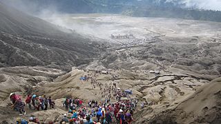
The Bromo, or Mount Bromo is an active somma volcano and part of the Tengger mountains, in East Java, Indonesia. At 2,329 meters (7,641 ft) it is not the highest peak of the massif, but is the most active and famous. The area is one of the most visited tourist destinations in East Java, and the volcano is included in the Bromo Tengger Semeru National Park. The name Bromo comes from the Javanese pronunciation of Brahma, the Hindu god of creation. At the mouth of the crater, there is an idol of Ganesha, the Hindu god of wisdom which is being worshipped by the Javanese Hindus. Mount Bromo is located in the middle of a plain called "Sea of Sand", a nature reserve that has been protected since 1919.

<span class="mw-page-title-main">Tenggerese people</span> Sub-ethnic group of Javanese

The Tenggerese people are a sub-ethnic group of Javanese in eastern Java who claim to be the descendants of the Majapahit princes. Their population of roughly 100,000 is centered in 30 villages in the isolated Tengger mountains in the Bromo Tengger Semeru National Park in eastern Java.

Tengger may refer to:

<span class="mw-page-title-main">Malang</span> City in East Java, Indonesia

Malang is an inland city in the Indonesian province of East Java. It has a history dating back to the age of Singhasari Kingdom. It is the second most populous city in the province, with a population of 820,043 at the 2010 Census and 843,810 at the 2020 Census; the official estimate as at mid 2022 was 846,126. The Malang Metropolitan area was home to 3,663,691 inhabitants in 2010, spread across two cities and 22 districts. Malang is the third largest city by economy in East Java, after Surabaya and Kediri, with an estimated 2016 GDP at Rp. 44.30 trillion.

<span class="mw-page-title-main">Semeru</span> Stratovolcano in Indonesia

The Semeru, or Mount Semeru is an active volcano located in East Java, Indonesia. It is located in a subduction zone, where the Indo-Australian plate subducts under the Eurasia plate. It is the highest mountain on the island of Java. The name "Semeru" is derived from Meru, the central world mountain in Hinduism, or Sumeru, the abode of gods. This stratovolcano is Mahameru, meaning "The Great Mountain" in Sanskrit. It is one of the more popular hiking destinations in Indonesia.

<span class="mw-page-title-main">Bromo Tengger Semeru National Park</span> National park in Indonesia

Bromo Tengger Semeru National Park is a national park located in East Java, Indonesia, to the east of Malang and Lumajang, to the south of Pasuruan and Probolinggo, and to the southeast of Surabaya, the capital of East Java. It is the only conservation area in Indonesia that has a sand sea, the Tengger Sand Sea, across which is the caldera of an ancient volcano (Tengger) from which four new volcanic cones have emerged. This unique feature covers a total area of 5,250 hectares at an altitude of about 2,100 meters (6,900 ft). The massif also contains the highest mountain in Java, Mount Semeru, four lakes and 50 rivers. It is named after the Tengger tribe. The explosion of the volcano that created the caldera, happened ca. 45.000 years ago, in an event similar to the Krakatau eruption.

<span class="mw-page-title-main">Cemoro Lawang</span> Dusun in Java, Indonesia

the inCemoro Lawang is a very small hamlet north-east of Mount Bromo, Indonesia with an altitude of 2,217 meters above sea level. Administratively, this hamlet is a part of Ngadisari Village, Sukapura, Probolinggo Regency. Cemoro Lawang is one of many routes that point to Tengger Caldera from the Probolinggo route. There is a viewpoint to see Mount Batok and Mount Bromo. It is principally a base for early morning climbs of Mt Bromo, an active volcano that stands in the middle of a Sand Sea. Many visitors approach the mountain from Surabaya which is about three hours drive away; others come from Bali.

<span class="mw-page-title-main">Lumajang Regency</span> Regency in Indonesia

Lumajang Regency is a Regency (kabupaten) located in the East Java province of Indonesia. It covers an area of 1,790.90 sq. km, and had a population of 1,006,458 at the 2010 Census and 1,119,251 at the 2020 Census. The mid 2022 official estimate as originally stated to be 1,137,230, but was revised down to 1,097,504. The regency shares its land borders with Jember Regency, Probolinggo Regency, and Malang Regency, while it borders the Indian Ocean to the south.

<span class="mw-page-title-main">Probolinggo Regency</span> Regency in East Java, Indonesia

Probolinggo Regency is a regency in East Java province of Indonesia. It covers an area of 1,696.17 sq. km, and had a population of 1,096,244 at the 2010 Census and 1,152,537 at the 2020 Census; the official estimate as at mid 2022 was 1,159,965. Its capital was formerly the city of Probolinggo, but after that city became an independent administrative identity the capital is now at Kraksaan.

<span class="mw-page-title-main">Ranu Kumbolo</span>

Ranu Kumbolo is a mountainous lake located in Bromo Tengger Semeru National Park, East Java, Indonesia. The lake is part of the easiest route from Ranu Pani to Mount Semeru Peak.

Ranu Tompe is a mountain lake located in Bromo Tengger Semeru National Park, East Java, Indonesia. Geographically, Ranu Tompe is isolated and far from human access. Ranu Tompe is only known from satellite images and maps of the area.

<span class="mw-page-title-main">Tosari</span>

Tosari is a village in the Tengger Mountains of East Java, Indonesia. It is near Pasuruan and is on a route to nearby Mount Bromo. The Tosari Sanitorium was advertised in a 1919 brochure.

Tenggerese is a language used by the Tenggerese people in the mountain region of the Bromo Tengger Semeru National Park which includes Pasuruan Regency, Probolinggo Regency, Malang Regency and Lumajang Regency of East Java, Indonesia.

<span class="mw-page-title-main">Eastern salient of Java</span> Geographical region in East Java, Indonesia

The eastern salient of Java is a region that makes up the easternmost part of the island of Java, Indonesia. It is not a formal or administrative subdivision, but rather a designation often used to refer to its distinct history, culture, and geographical feature. It is generally considered to begin in the Tengger mountain range and extend eastwards to the east coast of Java. It is entirely contained by the Indonesian province of East Java.

<span class="mw-page-title-main">Yadnya Kasada</span>

Yadnya Kasada, also known as Kesodo, is a traditional Hindu ritual of the Tenggerese people, an ethnic subgroup of the Javanese. The ritual serves as a way of expressing appreciation to their gods, whom they believe have granted them with blessings, abundance, and welfare.

<span class="mw-page-title-main">Mount Batok</span> Volcano in East Java, Indonesia

Mount Batok is a cinder cone located in East Java, Indonesia. This volcano has an elevation of 2,440 metres (8,005 ft) above sea level, and is located between four regencies: Probolinggo Regency, Pasuruan Regency, Lumajang Regency, and Malang Regency. The location of Mount Batok is west from Mount Bromo. This mountain is one of the inactive volcanoes located within the Tengger caldera. Mount Batok is part of Bromo Tengger Semeru National Park.

<span class="mw-page-title-main">Dutakom Wibawa Putra</span> Indonesian internet service provider company

PT Dutakom Wibawa Putra or commonly known as D~NET is an Indonesian internet service provider company based in Surabaya, Indonesia. The company focuses on technology as a provider of internet services and information technology of business solutions for corporations. The company was founded by Caroline Gondokusumo in 1997. Currently D-NET has 3 branch offices located in Malang, Denpasar and Mataram.

<span class="mw-page-title-main">Greater Malang</span> Region in East Java, Indonesia

Greater Malang is a region in East Java, Indonesia, encompassing the municipality of Malang and its hinterland. Over 3 million people in East Java reside in Greater Malang. The principal city, Malang is well known as the home of notable universities in Indonesia, and its suburb, Batu, is well known as a tourism centre in East Java.

On the evening of 6 September 2023, a fire broke out at Teletubbies Hill in Mount Bromo, East Java.

References

  1. "TNBTS". bromotenggersemeru.org (in Indonesian). Retrieved 18 October 2018.
  2. 1 2 "Ancaman di Balik Keindahan Danau Ranu Pani". Republika Online (in Indonesian). 7 July 2013. Retrieved 26 January 2019.
  3. 1 2 3 News, Top; Terkini; Pariwisata, Budaya &; Ekonomi; Hukum; Olahraga; Haji, Info; Politik; Mlaku-mlaku. "Objek Wisata Ranu Pani Lumajang Rusak Parah - ANTARA News Jawa Timur". Antara News (in Indonesian). Retrieved 26 January 2019.{{cite web}}: |last= has generic name (help)
  4. "Sejarah dan Kondisi Desa Ranupani". Ranupani. 7 September 2011. Retrieved 26 January 2019.
  5. "Tembus Minus 4 Derajat, Muncul Salju". Malang Post Online - Tepercaya, Cepat dan Akurat (in Indonesian). Retrieved 26 January 2019.
  6. Rahma, Maya. "Wah! Ranu Pani di Lumajang Bersalju | WartaBromo" (in Indonesian). Retrieved 26 January 2019.
  7. "Climate: Ranupani". Climate-Data.org. Retrieved 26 January 2019.
  8. "Warga Ranu Pani : Semeru Menggelegar Sudah Biasa". Surya (in Indonesian). 28 February 2014. Retrieved 26 January 2019.
  9. Fadillah, Ramadhian; Moerti, Wisnoe. "Madiasto, kisah sherpa dari Desa Ranu Pani". merdeka.com (in Indonesian). Retrieved 26 January 2019.
  10. 1 2 "Ranu Pani di Mata Kamera Mahasiswa UM". Surya (in Indonesian). 3 April 2014. Retrieved 26 January 2019.