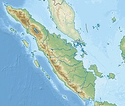
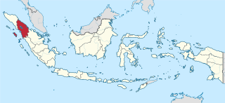
West Sumatra is a province of Indonesia. It is on the west coast of the island of Sumatra and includes the Mentawai Islands off that coast. West Sumatra borders the Indian Ocean to the west, as well as the provinces of North Sumatra to the north, Riau to the northeast, Jambi to the southeast, and Bengkulu to the south. The province has an area of 42,119.54 km2 (16,262.45 sq mi), or about the same size as Switzerland, with a population of 5,534,472 at the 2020 census. The official estimate at mid 2023 was 5,757,210. The province is subdivided into twelve regencies and seven cities. It has relatively more cities than other provinces outside Java, although several of them are relatively low in population compared with cities elsewhere in Indonesia. Padang is the province's capital and largest city.
North Sumatra, also called North Sumatra Province, is a province of Indonesia located in the northern part of the island of Sumatra, just south of Aceh. Its capital and largest city is Medan on the east coast of the island. It is bordered by Aceh on the northwest and Riau and West Sumatra on the southeast, by coastlines located on the Indian Ocean to the west, and by the Strait of Malacca to the east.

Bengkulu, historically known as Bencoolen, is a province of Indonesia. It is located on the southwest coast of Sumatra. It was formed on 18 November 1968 by separating out the area of the historic Bencoolen Residency from the province of South Sumatra under Law No. 9 of 1967 and was finalized by Government Regulation No. 20 of 1968. Spread over 20,130.21 km2, its area is comparable to the European country of Slovenia and it is bordered by the provinces of West Sumatra to the north, Jambi to the northeast, Lampung to the southeast, and South Sumatra to the east, and by the Indian Ocean to the northwest, south, southwest, and west.

Mount Kerinci, also spelled Kerintji, is an active stratovolcano and the highest mountain in Sumatra, Indonesia. At 12,484 ft (3,805 m) above sea level, it provides Sumatra with the fifth-highest maximum elevation of any island in the world. It is surrounded by the lush forest of Kerinci Seblat National Park, home to several endangered species including the Sumatran tiger. Mount Kerinci is ranked 32nd by topographic isolation.

Padang is the capital and largest city of the Indonesian province of West Sumatra. It had a population of 833,562 at the 2010 Census and 909,040 at the 2020 Census; the official estimate as at mid 2023 was 942,938 - comprising 473,089 males and 469,849 females. It is the 16th most populous city in Indonesia and the most populous city on the west coast of Sumatra. The Padang metropolitan area is the third most populous metropolitan area in Sumatra with a population of over 1.7 million. Padang is widely known for its Minangkabau culture, cuisine, and sunset beaches.

Bukittinggi is the third largest city in West Sumatra, Indonesia, with a population of 111,312 in 2010 and 121,028 in 2020, and an official estimate as at mid 2023 of 124,047 - comprising 61,949 males and 62,098 females. It covers an area of 25.24 km2. It is located in the Minangkabau Highlands, 90 km by road from the West Sumatran capital city of Padang. The city is completely surrounded by the Agam Regency, making it an enclave within the regency, and it is located at 0°18′20″S100°22′9″E, near the volcanoes Mount Singgalang (inactive) and Mount Marapi. At 930 m above sea level, the city has a cool climate with temperatures between 16.1° to 24.9 °C.

Gunung Leuser National Park is a national park covering 7,927 km2 in northern Sumatra, Indonesia, straddling the border of Aceh and North Sumatra provinces, a fourth portion and three-fourths portion, respectively. The national park, settled in the Barisan mountain range, is named after Mount Leuser (3,119 m), and protects a wide range of ecosystems. An orangutan sanctuary at Bukit Lawang is located within the park. Together with Bukit Barisan Selatan and Kerinci Seblat National Parks, it forms a World Heritage Site, the Tropical Rainforest Heritage of Sumatra.

The Trans-Sumatra Highway is a primary north–south road in the Indonesian island of Sumatra, 2,508.5 km in length, and connecting the northern island at Banda Aceh to Bandar Lampung in the south, running through many major cities, traversing Medan, Pekanbaru, Jambi, and Palembang along the way. Upgrade work is expected to begin in March 2013 transforming it into a full-fledged highway, including land acquisition.

Pagaruyung, also known as Pagarruyung, Pagar Ruyung and Malayapura or Malayupura, was a kingdom that once stood in the island of Sumatra and the seat of the Minangkabau kings of Western Sumatra. Modern Pagaruyung is a village in Tanjung Emas subdistrict, Tanah Datar regency, located near the town of Batusangkar, Indonesia.

The Great Sumatran fault, also known as Semangko fault, is a large strike-slip fault running the entire length of the island of Sumatra. This Indonesian island is located in a highly seismic area of the world, including a subduction zone off the west coast of the island.

Tanah Datar Regency is a landlocked regency (kabupaten) in West Sumatra province, Indonesia. The regency has an area of 1,337.1 km2 and had a population of 338,484 at the 2010 Census, which rose to 371,704 at the 2020 Census. The official estimate as of mid-2023 was 383,676 - comprising 193,190 males and 190,490 females. The regency seat is the town of Batusangkar. The city of Padang Panjang is also geographically located within the regency but constitutes a municipality of its own.

Pariaman, is a coastal city in West Sumatra, Indonesia. Pariaman covers an area of 73.36 km2 (28 sq mi), with a 12 km (7 mi) coastline. It had a population of 79,043 at the 2010 Census and 94,224 at the 2020 census; the official estimate as at mid 2023 was 97,206 - comprising 49,131 males and 48,075 females. "Pariaman" means "safe area".

Padang Pariaman Regency is a regency (kabupaten) of West Sumatra, Indonesia. It has an area of 1,343.58 km2, and it had a population of 390,204 at the 2010 census and 430,626 at the 2020 census; the official estimate as at mid 2023 was 451,388 - comprising 226,435 males and 224,953 females. The regency seat is at the town of Parit Malintang. West Sumatra's capital and biggest city, Padang, is surrounded on the landward side by this regency, which includes suburbs of the city.
The March 2007 Sumatra earthquakes occurred near the northern end of Lake Singkarak in Sumatra, Indonesia, on March 6. The first shock in this earthquake doublet struck with a maximum Mercalli intensity of VIII (Severe) and the second shock that arrived two hours later had a maximum Mercalli intensity of VI (Strong).
South Tapanuli is a regency in North Sumatra, Indonesia. Its seat is the town of Sipirok. This regency was originally very large and contained thousands of towns and villages, including the city of Padang Sidempuan. The areas that have separated from South Tapanuli Regency are the new regencies of Mandailing Natal, Padang Lawas Utara, and Padang Lawas, all lying to the south-east of the residual South Tapanuli Regency, plus the city (kota) of Padang Sidempuan. After the division, the regency seat moved from Padang Sidempuan to Sipirok.

Tour de Singkarak is an annual professional road bicycle racing stage race held in West Sumatra, Indonesia, and named after the Lake Singkarak. First staged in 2009, Tour de Singkarak is classified by the Union Cycling International (UCI) as a 2.2 category race as part of the UCI Asia Tour. It covers more than 1267 kilometres — from/to Padang passing around lake Singkarak and runs through inland West Sumatran cities — and lasted for a week and held annually. This exciting tour across the picturesque West Sumatra countryside's scenic landscapes, comprising beaches, blue lakes, and numerous hairpin bends, as they climb up to the foot of the volcanoes. The total prize money is IDR 1,000,000,000 (US$100,000). BNI-Maybank was the platinum sponsor of the Tour De Singkarak since 2009 with the Ministry of Culture and Tourism of Indonesia. TDS is the biggest international cycling race in Indonesia, having the fifth largest audience in the world, it attracted many top international cyclists to participate in this world famous annual sports event.
The 2012 Tour de Singkarak was the 4th edition of the Tour de Singkarak, one of Indonesian official tournament series of Union Cycliste International (UCI). It started on 4 June in Sawahlunto and ended in the Padang on 10 June. Like previous edition, the international cyclists competed in 7 stages over 7 days, which the routes has been surveyed by Amaury Sport Organization which surveyed also Tour de France routes. Covering a distance of 854 kilometres with prize money total to IDR 1 billion. The route across Lake Singkarak on stage 2 and stage 5.

Batikam Stone is a historical heritage object in Jorong Dusun Tuo, Nagari Limo Kaum, Tanah Datar Regency, on Sumatra in Indonesia. Translated from Indonesian, Batu Batikam means the stone that getting stabbed.

The Poso riots, also known as Poso communal conflict, is a name given to a series of riots that occurred in Poso, Central Sulawesi, Indonesia. This incident involved a group of Muslims and Christians in the region and was divided into three stages. The first Poso riot took place from December 25 to 29, 1998, continued from April 17 to 21, 2000, and finally from May 16 to June 15, 2000.
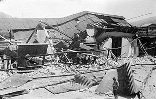
West Sumatra, Dutch East Indies was struck by an earthquake doublet on June 28, 1926. The first earthquake occurred at 10:23 local time, with an estimated magnitude of 6.7 on the surface wave magnitude scale with an intensity of IX (Violent) on the Modified Mercalli Intensity Scale. Less than three hours later, a second earthquake occurred with a magnitude of 6.4 Ms although it appears to have been less damaging. Three hundred and fifty-four people were killed during the first earthquake, with later shocks killing a total of 57 according to local records.