Sumatra is one of the Sunda Islands of western Indonesia. It is the largest island that is fully within Indonesian territory, as well as the sixth-largest island in the world at 482,286.55 km2 (182,812 mi.2), including adjacent islands such as the Simeulue, Nias, Mentawai, Enggano, Riau Islands, Bangka Belitung and Krakatoa archipelago.

Aceh, officially the Province of Aceh, is the westernmost province of Indonesia. It is located on the northern end of Sumatra island, with Banda Aceh being its capital and largest city. It is bordered by the Indian Ocean to the west, Strait of Malacca to the northeast, as well bordering the province of North Sumatra to the east, its sole land border, and shares maritime borders with Malaysia and Thailand to the east, and Andaman and Nicobar Islands of India to the north. Granted a special autonomous status, Aceh is a religiously conservative territory and the only Indonesian province practicing Sharia law officially. There are ten indigenous ethnic groups in this region, the largest being the Acehnese people, accounting for approximately 70% of the region's population of about 5.5 million people in mid-2023. Its area is comparable to Croatia or Togo.

Banda Aceh is the capital and largest city in the province of Aceh, Indonesia. It is located on the island of Sumatra and has an elevation of 35 meters. The city covers an area of 61.36 square kilometers (23.69 sq mi) and had a population of 223,446 people at the 2010 Census, rising to 252,899 at the 2020 Census. The official estimate as at mid 2023 was 261,969.

On 26 December 2004, at 07:58:53 local time (UTC+7), a major earthquake with a magnitude of 9.2–9.3 struck with an epicentre off the west coast of Aceh in northern Sumatra, Indonesia. The undersea megathrust earthquake, known by the scientific community as the Sumatra–Andaman earthquake, was caused by a rupture along the fault between the Burma plate and the Indian plate, and reached a Mercalli intensity of IX in some areas.
The 2004 Indian Ocean earthquake and tsunami occurred on Sunday, December 26, 2004. The earthquake itself, with a moment magnitude of around 9.2-9.3, devastated Aceh Province, Indonesia, while the tsunami affected countries all around the Indian Ocean. Nations which were affected are listed below in alphabetical order. For detailed information about each country affected by the earthquake and tsunami, see their individual articles. Countries with a smaller number of casualties, as well as those that lost citizens who were travelling abroad, are listed further on in the article.

Leupung -- also spelled "Leupueng", is a district in Aceh Besar regency, close to the city of Banda Aceh, the capital of the special territory of Aceh, Indonesia, on the island of Sumatra. Leupung is located at 5'31" North latitude and 95'15" East longitude at an elevation of 33 m. The population in 2004 was approximately 10,000; the district has been obliterated by the tsunami resulting from the 2004 Indian Ocean earthquake, being one of the towns closest to the earthquake's epicenter.

Indonesia was the first country to be seriously affected by the earthquake and tsunami created by the 2004 Indian Ocean earthquake on 26 December 2004, swamping the northern and western coastal areas of Sumatra, and the smaller outlying islands off Sumatra. Nearly all the casualties and damage took place within the province of Aceh. The time of arrival of the tsunami was between 15 and 30 minutes after the deadly earthquake. According to the country's National Disaster Relief Coordination Agency, around 130,000 people were dead and 37,063 were missing; deaths included 126,602 in Aceh and 130 in North Sumatra. In addition, the UN estimated that 655,000 people were homeless and sheltering in scattered refugee camps across the province.

A tsunami warning system (TWS) is used to detect tsunamis in advance and issue the warnings to prevent loss of life and damage to property. It is made up of two equally important components: a network of sensors to detect tsunamis and a communications infrastructure to issue timely alarms to permit evacuation of the coastal areas. There are two distinct types of tsunami warning systems: international and regional. When operating, seismic alerts are used to instigate the watches and warnings; then, data from observed sea level height are used to verify the existence of a tsunami. Other systems have been proposed to augment the warning procedures; for example, it has been suggested that the duration and frequency content of t-wave energy is indicative of an earthquake's tsunami potential.
The Indian Ocean Tsunami Warning System, abbreviated as IOTWS was set up to provide warning to inhabitants of nations bordering the Indian Ocean of approaching tsunamis. The tsunami warning system has been in use since the mid-2000s.

Library damage resulting from the 2004 Indian Ocean earthquake has been reported in six Asian countries. On December 26, the massive 2004 Indian Ocean earthquake struck off the northwest coast of the Indonesian island of Sumatra. The resulting tsunamis killed more than 180,000 people. In addition to the loss of human lives, cultural institutions were destroyed in several Asian nations. Libraries on the eastern coast of Sri Lanka and the northern province of Aceh on Sumatra were most severely affected by the disaster.

Weh Island is a small active volcanic island to the northwest of Sumatra in Indonesia, also known as Sabang after the city situated on the northeast end of the island, whose area of 122.13 square kilometres (47.15 sq mi) includes the whole island as well as several offshore islets. It had a population of 43,527 at the official mid-2023 estimate. It is 45 minutes by fast regular ship or 2 hours by ferry from the mainland port of Banda Aceh. It was originally connected to the Sumatran mainland and became separated by sea after the stratovolcano's last eruption in the Pleistocene era. The island is situated in the Andaman Sea.

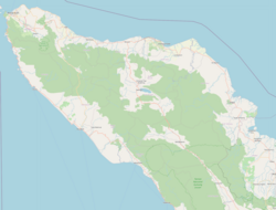
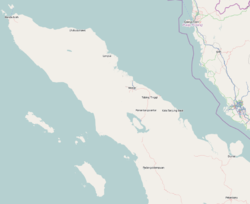
Simeulue is an island of Indonesia, 150 kilometres (93 mi) off the west coast of Sumatra. It covers an area of 1,754 square kilometres, including minor offshore islands. It had a population of 80,674 at the 2010 census and 92,865 at the 2020 census. The official estimate as at mid 2021 was 93,762. Its capital is Sinabang.

Baiturrahman Grand Mosque is a mosque located in Banda Aceh, Aceh, Indonesia. The Baiturrahman Grand Mosque is a symbol of religion, culture, spirit, strength, struggle, and nationalism of the Acehnese people. The mosque is a landmark in Banda Aceh and has survived the 2004 Indian Ocean earthquake and tsunami.
The 2003–2004 Indonesian offensive in Aceh, also known as Operation Integrated against the Free Aceh Movement (GAM) separatists was launched on 19 May 2003, and lasted nearly one year. It followed a two-week ultimatum to GAM to accept special autonomy under Indonesian rule. It was one of the Indonesian military's largest campaigns since the 1975 invasion of East Timor. It severely disabled the rebel movement, and along with the 2004 Indian Ocean earthquake and tsunami brought the 30-year conflict in Aceh to an end.

The insurgency in Aceh, officially designated the Rebellion in Aceh by the Indonesian government, was a conflict fought by the Free Aceh Movement (GAM) between 1976 and 2005, with the goal of making the province of Aceh independent from Indonesia. The aftermath of a military offensive in 2003 and the 2004 Indian Ocean earthquake and tsunami brought an peace agreement and an eventual end to the insurgency.
The 2012 Indian Ocean earthquakes were magnitude 8.6 and 8.2 Mw undersea earthquakes that struck near the Indonesian province of Aceh on 11 April at 15:38 local time. Initially, authorities feared that the initial earthquake would cause a tsunami and warnings were issued across the Indian Ocean; however, these warnings were subsequently cancelled. These were unusually strong intraplate earthquakes and the largest strike-slip earthquake ever recorded.

Aceh State Museum, popularly known as Aceh Museum or Banda Aceh Museum is a museum in Banda Aceh, Indonesia. It is one of the oldest museum in Indonesia.

The Simeulue people are an indigenous group of people inhabiting Simeulue Island off the west coast of Sumatra, Indonesia. They are mostly found in Teupah Barat, Simeulue Timur, Simeulue Tengah, Teupah Selatan and Teluk Dalam districts. The Simeulue people speak Simeulue, a Northwest Sumatra–Barrier Islands language closely related to Sikule and Nias. The language also has a strong Acehnese and Malay influence.
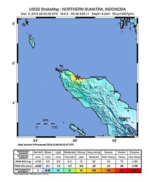
The 2016 Aceh earthquake struck the Indonesian island of Sumatra with a Mw of 6.5 in Aceh province on 7 December 2016, at 05:03 WIB. The shock was reported to be at a depth of 13 km, categorized as a strong, shallow earthquake. The epicentre was located near the village of Reuleut in Pidie Jaya Regency, 164 km (102 mi) southeast of the province's capital, Banda Aceh. 104 people died in the quake, with at least 1,000 people injured. It was the deadliest earthquake in Aceh since the 2005 Nias–Simeulue earthquake and the deadliest in Sumatra since the 2010 Mentawai earthquake and tsunami.
Building Back Better, or more frequently termed Build Back Better (BBB), is a strategy aimed at reducing the risk to the people of nations and communities in the wake of future disasters and shocks. It is a conceptual strategy that has continued to evolve since its origination in May 2005. However, what continues is the overall goal of enabling countries and communities to be stronger and more resilient following a disaster by reducing vulnerability to future disasters. Building resilience entails addressing physical, social, environmental, and economic vulnerabilities and shocks.