A swamp is a forested wetland. Swamps are considered to be transition zones because both land and water play a role in creating this environment. Swamps vary in size and are located all around the world. The water of a swamp may be fresh water, brackish water, or seawater. Freshwater swamps form along large rivers or lakes where they are critically dependent upon rainwater and seasonal flooding to maintain natural water level fluctuations. Saltwater swamps are found along tropical and subtropical coastlines. Some swamps have hammocks, or dry-land protrusions, covered by aquatic vegetation, or vegetation that tolerates periodic inundation or soil saturation. The two main types of swamp are "true" or swamp forests and "transitional" or shrub swamps. In the boreal regions of Canada, the word swamp is colloquially used for what is more formally termed a bog, fen, or muskeg. Some of the world's largest swamps are found along major rivers such as the Amazon, the Mississippi, and the Congo.
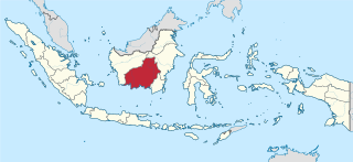
Central Kalimantan is a province of Indonesia. It is one of five provinces in Kalimantan, the Indonesian part of Borneo. Its provincial capital is Palangka Raya and in 2010 its population was over 2.2 million, while the 2015 Intermediate Census showed a rise to 2.49 million and the 2020 Census showed a total of 2.67 million; the official estimate as at mid 2021 was 2,702,200.

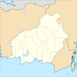
Palangka Raya is the capital and largest city of the Indonesian province of Central Kalimantan. The city is situated between the Kahayan and the Sabangau rivers on the island of Borneo. As of the 2020 census, the city has a population of 293,500; the official estimate as at mid 2021 was 298,950. Palangka Raya is the largest city by land area in Indonesia. Most of the area is forested. It also has the highest Human Development Index rating of any city in Kalimantan.
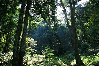
Peat swamp forests are tropical moist forests where waterlogged soil prevents dead leaves and wood from fully decomposing. Over time, this creates a thick layer of acidic peat. Large areas of these forests are being logged at high rates.
Environmental issues in Indonesia are associated with the country's high population density and rapid industrialisation, and they are often given a lower priority due to high poverty levels, and an under-resourced governance.

Nepenthes × hookeriana, or Hooker's pitcher-plant, is a common natural hybrid involving N. ampullaria and N. rafflesiana. It was originally described as a species.

The Borneo peat swamp forests ecoregion, within the tropical and subtropical moist broadleaf forests biome, are on the island of Borneo, which is divided between Brunei, Indonesia and Malaysia.
Mount Palung National Park lies on the island of Borneo, in the Indonesian province of West Kalimantan, north of Ketapang and east of Sukadana.

Tropical peat is a type of histosol that is found in tropical latitudes, including South East Asia, Africa, and Central and South America. Tropical peat mostly consists of dead organic matter from trees instead of spaghnum which are commonly found in temperate peat. This soils usually contain high organic matter content, exceeding 75% with dry low bulk density around 0.2 mg/m3 (0.0 gr/cu ft).

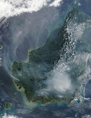
The Southeast Asian haze is a fire-related recurrent transboundary air pollution issue. Haze events, where air quality reaches hazardous levels due to high concentrations of airborne particulate matter from burning biomass, have caused adverse health, environmental and economic impacts in several countries in Southeast Asia. Caused primarily by slash-and-burn land clearing, the problem flares up every dry season to varying degrees and generally is worst between July and October and during El Niño events. Transboundary haze in Southeast Asia has been recorded since 1972 with the 1997 and 2015 events being particularly severe.

The Kahayan river, or Great Dayak River, is the second largest river after Barito River in Central Kalimantan, a province of Indonesia in Kalimantan – the Indonesian part of the island of Borneo. With a total length of 658 km (409 mi) and with a drainage basin of 15,500 km2 (6,000 sq mi) in South Kalimantan, Indonesia. Mean annual discharge 1,178 m3/s (41,600 cu ft/s). The provincial capital Palangkaraya lies on the river. The main inhabitants are Dayaks, who practice slash-and-burn rice cultivation and pan for gold on the upper reaches. The lower Kayahan flows through a rich and unusual environment of peat swamp forests, which has been severely degraded by an unsuccessful program to convert a large part of the area into rice paddies, compounded by legal and illegal forestry.

The Mega Rice Project was initiated in 1996 in the southern sections of Kalimantan, the Indonesian section of Borneo. The goal was to turn one million hectares of unproductive and sparsely populated peat swamp forest into rice paddies in an effort to alleviate Indonesia's growing food shortage. The government made a large investment in constructing irrigation canals and removing trees. The project did not succeed, and was eventually abandoned after causing considerable damage to the environment.
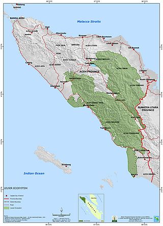
The Leuser Ecosystem is an area of forest located in the provinces of Aceh and North Sumatra on the island of Sumatra in Indonesia. Covering more than 2.6 million hectares it is one of the richest expanses of tropical rain forest in Southeast Asia and is the last place on earth where the Sumatran elephant, rhino, tiger and orangutan are found within one area. It has one of the world's richest yet least-known forest systems, and its vegetation is an important source of Earth's oxygen.

The Borneo Orangutan Survival (BOS) Foundation is an Indonesian non-profit non-governmental organization founded by Dr. Willie Smits in 1991 and dedicated to the conservation of the endangered Bornean orangutan and its habitat through the involvement of local people. It is audited by an external auditor company and operates under the formal agreement with the Indonesian Ministry of Forestry to conserve and rehabilitate orangutans. The BOS Foundation manages orangutan rescue, rehabilitation and re-introduction programmes in East and Central Kalimantan. With more than 400 orangutans in its care and employing more than 440 people at a 10 sites BOS Foundation is the biggest non-human primate conservation non-governmental organization worldwide. Nyaru Menteng and Samboja Lestari are the BOS Foundation sites that have received most extensive media coverage. Nyaru Menteng, founded by Lone Drøscher Nielsen, has been the subject of a number of TV series, including Orangutan Diary, Orangutan Island and the series Orangutan Jungle School, airing since 2018.

Tanjung Puting National Park is a national park in Indonesia located in the southeast part of West Kotawaringin Regency in the Indonesian province of Central Kalimantan. The nearest main town is the capital of the Regency, Pangkalan Bun. The park is famous for its orangutan conservation.

Deforestation in Borneo has taken place on an industrial scale since the 1960s. Borneo, the third largest island in the world, divided between Indonesia, Malaysia and Brunei, was once covered by dense tropical and subtropical rainforests.

The Rimba Raya Biodiversity Reserve, nearly the size of Singapore, consists of 64,000 hectares of bio-diverse tropical peat swamp forest that contain as much as 1,000 plant and animal species per hectare and is one of the most highly endangered ecosystems on the planet. The project area and ongoing initiatives focus on environmental conservation, community outreach, and climate control. Rimba Raya is home to one of the few remaining relic populations of wild orangutans and is the largest privately funded orangutan reserve in the world. The area is also one of the world’s largest repositories of carbon. Rimba Raya is the world’s largest REDD+ project -Reduced Emissions from (Avoided) Deforestation and Degradation (REDD). The project developer, InfiniteEARTH, is an industry pioneer, delivering the world’s first REDD methodology in 2009.
A mire, peatland, or quagmire is a wetland area dominated by living peat-forming plants. Mires arise because of incomplete decomposition of organic matter, usually litter from vegetation, due to water-logging and subsequent anoxia. All types of mires share the common characteristic of being saturated with water, at least seasonally with actively forming peat, while having their own ecosystem. Like coral reefs, mires are unusual landforms that derive mostly from biological rather than physical processes, and can take on characteristic shapes and surface patterning.
Paludiculture is wet agriculture and forestry on peatlands. Paludiculture combines the reduction of greenhouse gas emissions from drained peatlands through rewetting with continued land use and biomass production under wet conditions. “Paludi” comes from the Latin “palus” meaning “swamp, morass” and "paludiculture" as a concept was developed at Greifswald University. Paludiculture is a sustainable alternative to drainage-based agriculture, intended to maintain carbon storage in peatlands. This differentiates paludiculture from agriculture like rice paddies, which involve draining, and therefore degrading wetlands.

There are three species of orangutan. The Bornean orangutan, the most common, can be found in Kalimantan, Indonesia and Sarawak and Sabah in Malaysia. The Sumatran orangutan and the Tapanuli orangutan are both only found in Sumatra, Indonesia. The conservation status of all three of these species is critically endangered, according to the International Union for Conservation of Nature (IUCN) Red List.