Wasur National Park

Last updated
Wasur National Park
Taman Nasional Wasur
Wasur Rainbow 1994.jpg
Indonesia South Papua location map.svg
Red pog.svg
Wasur NP
Location of Wasur NP in Papua
Location South Papua, Indonesia
Nearest city Merauke
Coordinates 8°36′S140°50′E / 8.600°S 140.833°E / -8.600; 140.833
Area4,138 km2
Established1990
Visitors2,265(in 2004 [1] )
Governing body Ministry of Environment and Forestry
Designated16 March 2006
Reference no.1624 [2]

The Wasur National Park forms part of the largest wetland in Merauke Regency, South Papua, Indonesia and has been one of the least disturbed by human activity. [3] The high value of its biodiversity has led to the park being dubbed the "Serengeti of Papua". [3] The vast open wetland, in particular Rawa Biru Lake, attracts a very rich fauna.

Contents

Vegetation and fauna

Melaleucas Melaleuca.Sp lahan basah TN Wasur.jpg
Melaleucas
Morelia viridis in Wasur NP Perayap malam arboreal dari tanah Papua - Sanca Hijau (Morelia viridis) TN Wasur.jpg
Morelia viridis in Wasur NP

About 70% of the total area of the park consists of savanna (see Trans-Fly savanna and grasslands), while the remaining vegetation is swamp forest, monsoon forest, coastal forest, bamboo forest, grassy plains and large stretches of sago swamp forest. The dominant plants include mangroves, Terminalia, and Melaleuca species. [3]

The park provides habitat for a large variety of up to 358 bird species of which some 80 species are endemic to the island of New Guinea. Fish diversity is also high in the region with some 111 species found in the eco-region and a large number of these are recorded from Wasur. [4] The park's wetland provides habitat for various species of lobster and crab as well.

Common fauna species include the agile wallaby, [5] Pesquet's parrot, southern cassowary, blue crowned pigeon, greater bird-of-paradise, king bird-of-paradise, red bird-of-paradise, New Guinea crocodile, and saltwater crocodile. [3]

Wasur National Park is the habitat for a number of rare and endemic species. Red Listed species known to be present in viable populations are southern crowned pigeon, New Guinea harpy eagle, dusky pademelon, black-necked stork, Fly River grassbird and little curlew. Three trans-Fly endemic bird species have been recorded, including the Fly River grassbird and the grey-crowned munia. [4]

The introduction of the rusa deer to Papua by the Dutch at Merauke in 1928, led to an extensive spread of this species to most of the southern coastlands of the island. According to the indigenous communities of the national park, this led to major changes to the local ecosystem, including: the reduction of tall swamp grasses and consequent ceasing of breeding of the Australian pelican and magpie goose, reduction of the Phragmites reed species, and the extensive spread of Melaleuca onto the open grasslands. [6]

Conservation

Satellite image of Southern New Guinea, Wasur NP and Tonda WMA are located between the Merauke and Fly Rivers. Wildfires of 2002 are marked in red. Southern New Guinea Fires 2002.jpg
Satellite image of Southern New Guinea, Wasur NP and Tonda WMA are located between the Merauke and Fly Rivers. Wildfires of 2002 are marked in red.

The Wasur area was first designated as a wildlife reserve in 1978 with an area of 2,100 km2. An extended area of 4,138 km2 was later declared a national park in 1990. In 2006 the park has been also recognised as a wetland of international importance under the Ramsar Convention. Wasur shares a common border with Tonda Wildlife Management Area (WMA), another Ramsar site in neighbouring Papua New Guinea. Wasur National Park has been the site of a World Wide Fund for Nature (WWF) conservation and development project since 1991. [4] In 1995 a Tri-National Wetlands Program has been initiated by WWF between Wasur NP, Tonda WMA and the Australian Kakadu National Park, which led to a Memorandum of Understanding between the three government conservation agencies in 2002. [7]

Human habitation

There are four groups of indigenous peoples living in the park, belonging to the tribes of Kanume, Marind, Marori Men-Gey and Yei, who rely on the area for food and their daily needs. The total population is estimated to be 2,500 within 14 villages. [8] The name of the park is derived from the Marori language in which Waisol means garden. [9] These local communities consume fish, sago, sweet potato, deer, bandicoot and wallaby. Many aspects of their culture are disappearing although some elements such as festivals, pig feasts, dancing, weaving and traditional cooking remain. There are many sites of spiritual significance including sacred sites. The southern part of the park has large areas of ancient agricultural mounds which are of archaeological importance. [4]

Threats

Much of the park's natural flooded grassland systems are threatened by large scale changes to scrub and woodland as well as invasions of alien species such as water hyacinth and mimosa pigra. The New Guinea crocodile habitat is in danger as a consequence of skin trading. [4] As in other parts of Indonesia and New Guinea, illegal logging has been witnessed in Wasur National Park as well. [10]

See also

Related Research Articles

<span class="mw-page-title-main">Bowling Green Bay National Park</span> Protected area in Queensland, Australia

Bowling Green Bay is a national park in the City of Townsville and Shire of Burdekin, Queensland, Australia, 1,103 km northwest of Brisbane, and 28 km south of Townsville and 59 km north of Ayr. It is a Ramsar Convention listed site. The park protects diverse range of habitats including the rugged, forested landscape surrounding Mount Elliot and Saddle Mountain as well as coastal estuaries between Cape Cleveland and Cape Bowling Green.

<span class="mw-page-title-main">Western New Guinea</span> Region of Indonesia on the island of New Guinea

Western New Guinea, also known as Papua, Indonesian New Guinea, and Indonesian Papua, is the western, Indonesian half of the island of New Guinea. Since the island is alternatively named Papua, the region is also called West Papua.

<span class="mw-page-title-main">Western Province (Papua New Guinea)</span> Place in Papua New Guinea

Western Province is a coastal province in southwestern Papua New Guinea, bordering the Indonesian provinces of Highland Papua and South Papua. The provincial capital is Daru. The largest town in the province is Tabubil. Other major settlements are Kiunga, Ningerum, Olsobip and Balimo.

<span class="mw-page-title-main">Koshi Tappu Wildlife Reserve</span> Wildlife Reserve of Nepal

The Koshi Tappu Wildlife Reserve is a protected area in the Terai of eastern Nepal covering 176 km2 (68 sq mi) of wetlands in the Sunsari, Saptari and Udayapur Districts. It comprises extensive reed beds and freshwater marshes in the floodplain of the Kosi River, and ranges in elevation from 75 to 81 m. It was established in 1976 and designated as a Ramsar site in December 1987. It hosts Nepal's last remaining herd of the wild water buffalo.

<span class="mw-page-title-main">Terai–Duar savanna and grasslands</span>

The Terai–Duar savanna and grasslands is a narrow lowland ecoregion at the base of the Himalayas, about 25 km (16 mi) wide, and a continuation of the Indo-Gangetic Plain in India, Nepal and Bhutan. It is colloquially called Terai in the Ganges Basin east to Nepal, then Dooars in West Bengal, Bhutan and Assam east to the Brahmaputra River. It harbours the world's tallest grasslands, which are the most threatened and rare worldwide.

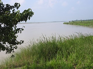
The Maro River also known as Sungai Merauke and Merauke-rivier, Merauki River flows in Merauke Regency, Papua, Indonesia. It is located just to the west of the Bensbach River of Western Province, Papua New Guinea.

<span class="mw-page-title-main">Wildlife of Burkina Faso</span> Flora and fauna of the landlocked west African country

Burkina Faso is largely wild bush country with a mixture of grass and small trees in varying proportions. The savanna region is mainly grassland in the rainy season and semi desert during the harmattan period. Fauna, one of the most diverse in West Africa, includes the elephant, hippopotamus, buffalo, monkey, lions, crocodile, giraffe, various types of antelope, and a vast variety of bird and insect life. The country has 147 mammal species, 330 aquatic species including 121 species of fish and 2067 different plant species. Of the plant species, the dominant endemic species are shea tree and the baobab, the former plant species has immense economic value to the country.

<span class="mw-page-title-main">Wildlife of Ivory Coast</span> Flora and fauna of Ivory Coast in West Africa

The wildlife of Ivory Coast consists of the flora and fauna of this nation in West Africa. The country has a long Atlantic coastline on the Gulf of Guinea and a range of habitat types. Once covered in tropical rainforest, much of this habitat has been cleared, the remaining terrain being gallery forests and savanna with scattered groups of trees, resulting in a decrease in biodiversity. As of 2016, 252 species of mammal had been recorded in Ivory Coast, 666 species of bird, 153 species of reptile, 80 species of amphibian, 671 species of fish and 3660 species of vascular plant.

<span class="mw-page-title-main">Wildlife of the Gambia</span>

The wildlife of the Gambia is dictated by several habitat zones over the Gambia's land area of about 10,000 km2. It is bound in the south by the savanna and on the north by the Sudanian woodlands. The habitats host abundant indigenous plants and animals, in addition to migrant species and newly planted species. They vary widely and consist of the marine system, coastal zone, estuary with mangrove vegetation coupled with Banto Faros, river banks with brackish and fresh water zones, swamps covered with forests and many wetlands.

<span class="mw-page-title-main">Wildlife of Togo</span>

The wildlife of Togo is composed of the flora and fauna of Togo, a country in West Africa. Despite its small size the country has a diversity of habitats; there are only remnants of the once more extensive rain forests in the south, there is Sudanian savanna in the north-western part of the country and larger areas of Guinean forest–savanna mosaic in the centre and north-east. The climate is tropical with distinct wet and dry seasons. There are estimated to be over 3000 species of vascular plants in the country, and 196 species of mammals and 676 species of birds have been recorded there.

<span class="mw-page-title-main">New Guinea mangroves</span> Mangrove ecoregion that covers extensive areas of the coastline New Guinea

The New Guinea mangroves is a mangrove ecoregion that covers extensive areas of the coastline New Guinea, the large island in the western Pacific Ocean north of Australia.

Assagny National Park or Azagny National Park is a national park in the south of Ivory Coast. It is situated on the coast some 75 km (47 mi) to the west of Abidjan, between the mouth of the Bandama River and the Ébrié Lagoon, and occupies an area of about 17,000 hectares.

<span class="mw-page-title-main">New Guinea</span> Island in the Pacific Ocean

New Guinea is the world's second-largest island, with an area of 785,753 km2 (303,381 sq mi). Located in Melanesia in the southwestern Pacific Ocean, the island is separated from Australia by the 150-kilometre wide Torres Strait, though both landmasses lie on the same continental shelf, and were united during episodes of low sea level in the Pleistocene glaciations as the combined landmass of Sahul. Numerous smaller islands are located to the west and east. The island's name was given by Spanish explorer Yñigo Ortiz de Retez during his maritime expedition of 1545 due to the resemblance of the indigenous peoples of the island to those in the African region of Guinea.

<span class="mw-page-title-main">Shuklaphanta National Park</span>

Shuklaphanta National Park is a national park in the Terai of the Far-Western Region, Nepal, covering 305 km2 (118 sq mi) of open grasslands, forests, riverbeds and tropical wetlands at an elevation of 174 to 1,386 m. It is bounded by the Mahakali river in the west and south. A small part extends north of the Mahendra Highway to create a wildlife corridor for seasonal migration of wildlife into the Sivalik Hills. It was gazetted in 1976 as Royal Shuklaphanta Wildlife Reserve and was enlarged to its present size in the late 1980s. A buffer zone of 243.5 km2 (94.0 sq mi) was added in 2004. It receives a mean annual rainfall of 1,579 mm (62.2 in) and harbours 700 floral, 456 bird, 56 reptile and 15 amphibian species.

<span class="mw-page-title-main">Trans-Fly savanna and grasslands</span> Ecoregion in New Guinea

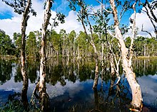
The Trans Fly savanna and grasslands are a lowland ecoregion on the south coast of the island of New Guinea in both the Indonesian and Papua New Guinean sides of the island. With their monsoon and dry season climate these grasslands are quite different from the tropical rainforest that covers most of the island and resemble the landscape of northern Australia which lies to the south.

<span class="mw-page-title-main">Tonda Wildlife Management Area</span>

The Tonda Wildlife Management Area is a wetland of international importance and the largest protected area in Papua New Guinea. It is located in the south-western corner of the Western Province and is contiguous with Wasur National Park of Indonesia. It forms part of the Trans Fly savanna and grasslands ecoregion.

<span class="mw-page-title-main">Morori language</span> Language in Papua

Morori is a moribund Papuan language of the Kolopom branch of the Trans–New Guinea family. It is separated from the other Kolopom languages by the intrusive Marind family. All speakers use Papuan Malay or Indonesian as L2, and many know Marind.
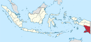
<span class="mw-page-title-main">Oti Valley Faunal Reserve</span>

The Oti Valley Faunal Reserve is a protected area in northeastern Togo, one of four Important Bird Areas (IBA) in the country. The site is mainly savanna and seasonally inundated floodplains on either side of the Oti River. It has a total area of 147,840 hectares and is located at 10°35'N and 0°40'E.

The Bensbach River is a river in southwestern Papua New Guinea. It is located just to the east of the Maro River in Merauke Regency, Indonesia, and just to the west of the Morehead River in Papua New Guinea.

The Morehead River is a river in southwestern Papua New Guinea. It is located just to the east of the Bensbach River, and to the west of the Fly River. The river flows through the Trans-Fly savanna and grasslands.

References

  1. Forestry statistics of Indonesia 2007, retrieved 20 May 2010
  2. "Wasur National Park". Ramsar Sites Information Service. Retrieved 25 April 2018.
  3. 1 2 3 4 Indonesian Ministry of Forestry, retrieved 2009-10-30
  4. 1 2 3 4 5 Ramsar Sites Database, retrieved 2009-10-30
  5. Cochrane, Janet: The National Parks and other Wild Places of Indonesia, New Holland Publishers, 2000, ISBN   1-85974-193-2
  6. Bowe, Michele et al.: Grassland and Savanna Ecosystems of the Trans-Fly, Southern Papua in Marshall A.J.: The Ecology of Papua, Periplus, Singapore, 2007, ISBN   0-7946-0483-8
  7. Bowe, Michele: Community-Based Conservation in the Trans-Fly Region, in Marshall A.J.: The Ecology of Papua, Periplus, Singapore, 2007, ISBN   0-7946-0483-8
  8. Robert F. Kennedy Memorial Center for Human Rights: The West Papua Report April 2005
  9. Lestari Hutan Indonesia (LHI) [ permanent dead link ], retrieved 2010-01-10
  10. Pacific Journalism Review 14-(1)-2008: Media blind spot over West Papua , retrieved 2009-10-30