
Denpasar is the capital city of the province of Bali, Indonesia. Denpasar is the main gateway to the Bali island, the city is also a hub for other cities in the Lesser Sunda Islands.

Ubud is a town on the Indonesian island of Bali in Ubud District, located amongst rice paddies and steep ravines in the central foothills of the Gianyar regency. Promoted as an arts and culture centre, it has developed a large tourism industry. It forms a northern part of the Greater Denpasar metropolitan area.

Magelang is one of six cities in Central Java Province of Indonesia that are administratively independent of the regencies in which they lie geographically. Each of these cities is governed by a mayor rather than a bupati. Magelang city covers an area of 18.54 km2 and has a population of 118,227 at the 2010 census and 121,526 at the 2020 census; the official estimate as at mid 2022 was 121,675. It is geographically located in the middle of the Magelang Regency, between Mount Merbabu and Mount Sumbing in the south of the province, and lies 43 km north of Yogyakarta, 15 km north of Mungkid and 75 km south of Semarang, the capital of Central Java.

West Jakarta is one of the five administrative cities of the Special Capital Region of Jakarta, Indonesia. West Jakarta is not self-governed and does not have a city council, hence it is not classified as a proper municipality. It had a population of 2,281,945 at the 2010 Census and 2,434,511 at the 2020 Census; the official estimate as at mid 2022 was 2,589,589 according to the BPS webpage for Jakarta Barat; however, the figure for Jakarta Barat according to the BPS DKI Jakarta webpage was 2,448,975. The administrative center of West Jakarta is at Puri Kembangan.

Bondowoso Regency is a landlocked regency in East Java, Indonesia. It covers an area of 1,518.77 km2, and had a population of 736,772 at the 2010 Census and 776,151 at the 2020 Census; the official estimate as at mid 2022 was 781,417. The most common languages are Madurese and Javanese, although Madurese is the majority. The nearest large city is Surabaya, approximately five hours' drive away.
Istana is an Indonesian and Malay word meaning "palace". It may refer to the following palaces:

Sleman Regency is an Indonesian regency on the island of Java. It is located in the north of the Yogyakarta Special Administrative Region, Indonesia, and has an area of 574.82 square kilometres (221.94 sq mi), with a population of 1,093,110 at the 2010 Census and 1,125,804 at the 2020 Census; the official estimate as at mid 2022 was 1,147,562 - comprising 569,577 males and 577,985 females. Its capital is the town of Sleman. The current regent is Kustini Sri Purnomo.
Wonogiri Regency is a regency in the southeastern part of Central Java province in Indonesia. It covers an area of 1,904.32 km2, and its population was 928,904 at the 2010 Census and 1,043,177 at the 2020 Census; the official estimate as at mid 2022 was 1,057,087. The capital and largest town is Wonogiri, around 33 km southeast of the large Central Java metropolis of Surakarta.

Subang Regency is a regency (kabupaten) in West Java province, Indonesia. The Regency is bordered by the Java Sea in the north, Indramayu Regency in the east, Sumedang Regency in the southeast, West Bandung Regency in the south, and Purwakarta Regency and Karawang Regency in the west. It has an area of 2,165.55 km2 (836.12 sq mi) and its population was 1,465,157 at the 2010 census and 1,595,320 at the 2020 census; the official estimate as of mid-2022 was 1,624,386. Its administrative seat is in the town of Subang.

Klungkung Regency is the smallest regency (kabupaten) in the island province of Bali, Indonesia. It has an area of 315 km2 and had a population at the 2010 Census of 170,543 which increased to 206,925 at the Census of 2020; the official estimate as at mid 2022 was 214,012. The administrative centre for the regency is in the town of Semarapura.

Bangli Regency is the one and only landlocked regency (kabupaten) of Bali, Indonesia. It covers an area of 520.81 km2 and had a population of 215,353 at the 2010 Census and 258,721 at the 2020 Census; the official estimate as at mid 2022 was 267,133 - comprising 134,500 males and 132,600 females. Its regency seat is the town of Bangli.

Gianyar Regency is a regency (kabupaten) in the Indonesian province and island of Bali, Indonesia. It has an area of 368.0 km2 and had a population of 469,777 at the 2010 Census, and 515,344 at the 2020 Census, making it the second most densely populated district in Bali ; the official estimate as of mid-2022 was 523,973 - comprising 262,708 males and 261,264 females. Its regency seat is the town of Gianyar. The civil registry survey of April 2011 listed 480,447 people, of which 469,929 were classified as Hindu.

Tirta Gangga is a former royal palace in eastern Bali, Indonesia, about 5 kilometres from Karangasem, near Abang. Named after the sacred river Ganges in Hinduism, it is noted for the Karangasem royal water palace, bathing pools and its Patirthan temple. The one hectare complex was built in 1946 by the late King of Karangsem but was destroyed almost entirely by the eruption of nearby Mount Agung in 1963.
Kintamani is a district (kecamatan), and a village within that district, on the western edge of the larger caldera wall of the Mount Batur caldera in Bali, Indonesia. It is on the same north–south road as Penelokan and has been used as a stopping place to view the Mount Batur region. Kintamani is also known for Pura Tuluk Biyu's 1,000-year-old "Rites of Peace" stone tablets and the Kintamani dog breed. It is situated next to Mount Batur.

Tirta Empul temple is a Hindu Balinese water temple located near the town of Tampaksiring, Bali, Indonesia. The temple compound consists of a petirtaan or bathing structure, famous for its holy spring water, where Balinese Hindus go to for ritual purification. The temple pond has a spring which gives out fresh water regularly, which Balinese Hindus consider to be holy or amritha. Tirta Empul means Holy Spring in Balinese.
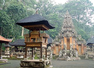
A Pura is a Balinese Hindu temple, and the place of worship for adherents of Balinese Hinduism in Indonesia. Puras are built following rules, style, guidance, and rituals found in Balinese architecture. Most puras are found on the island of Bali, where Hinduism is the predominant religion; however many puras exist in other parts of Indonesia where significant numbers of Balinese people reside. Mother Temple of Besakih is the most important, largest, and holiest temple in Bali. Many Puras have been built in Bali, leading it to be titled "the Island of a Thousand Puras".

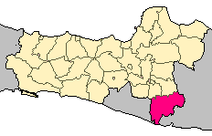
Karangasem Regency is a regency (kabupaten) of the island and province of Bali, Indonesia. It covers the east part of Bali, has an area of 839.54 km2 and had a population of 396,487 at the 2010 Census which rose to 492,402 at the 2020 Census; the official estimate as at mid 2022 was 511,300. Its regency seat is the town of Amlapura. Karangasem was devastated when Mount Agung erupted in 1963, killing 1,900 people. Karangasem was a kingdom before Bali was conquered by the Dutch.
Blahbatuh is a district in Gianyar Regency, Bali, Indonesia. As of the 2010 census, the area was 39.70 km2 and the population was 65,875; the latest official estimate is 72,140.

The archaeology of Indonesia is the study of the archaeology of the archipelagic realm that today forms the nation of Indonesia, stretching from prehistory through almost two millennia of documented history. The ancient Indonesian archipelago was a geographical maritime bridge between the political and cultural centers of Ancient India and Imperial China, and is notable as a part of ancient Maritime Silk Road.
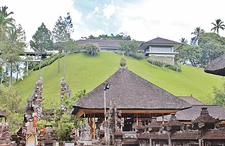
The Tampaksiring Palace is one of 6 Presidential Palaces of Indonesia, it is located in Tampaksiring, Gianyar Regency, Bali. Built in 1957 and finished in 1963, unlike other presidential palaces of Indonesia that mostly were inherited from the colonial period of Dutch East Indies, Istana Tampaksiring was built after the independence of Indonesia, and built not in colonial Indies Empire style, but in modernism combined with elements of Balinese architecture.


