"},"topo":{"wt":""},"type":{"wt":"[[Somma volcano]]"},"age":{"wt":""},"last_eruption":{"wt":"December 13,2023"},"first_ascent":{"wt":""},"easiest_route":{"wt":""}},"i":0}}]}" id="mwDQ">.mw-parser-output .infobox-subbox{padding:0;border:none;margin:-3px;width:auto;min-width:100%;font-size:100%;clear:none;float:none;background-color:transparent}.mw-parser-output .infobox-3cols-child{margin:auto}.mw-parser-output .infobox .navbar{font-size:100%}@media screen{html.skin-theme-clientpref-night .mw-parser-output .infobox-full-data:not(.notheme)>div:not(.notheme)[style]{background:#1f1f23!important;color:#f8f9fa}}@media screen and (prefers-color-scheme:dark){html.skin-theme-clientpref-os .mw-parser-output .infobox-full-data:not(.notheme) div:not(.notheme){background:#1f1f23!important;color:#f8f9fa}}@media(min-width:640px){body.skin--responsive .mw-parser-output .infobox-table{display:table!important}body.skin--responsive .mw-parser-output .infobox-table>caption{display:table-caption!important}body.skin--responsive .mw-parser-output .infobox-table>tbody{display:table-row-group}body.skin--responsive .mw-parser-output .infobox-table tr{display:table-row!important}body.skin--responsive .mw-parser-output .infobox-table th,body.skin--responsive .mw-parser-output .infobox-table td{padding-left:inherit;padding-right:inherit}}
Mount Bromo | |
---|---|
![]() | |
Highest point | |
Elevation | 2,329 m (7,641 ft) [1] |
Listing | Spesial Ribu |
Coordinates | 7°56′30″S112°57′00″E / 7.94167°S 112.95000°E [1] |
Geography | |
Geology | |
Mountain type | Somma volcano |
Last eruption | December 13, 2023 |
The Bromo (Javanese : ꦧꦿꦩ), or Mount Bromo (Javanese : ꦒꦸꦤꦸꦁꦧꦿꦩ, Indonesian : Gunung Bromo) is an active somma volcano, a Hindu pilgrimage site, and part of the Tengger mountains, in East Java, Indonesia. At 2,329 meters (7,641 ft) it is not the highest peak of the massif, but is the most active and famous. The area is one of the most visited tourist destinations in East Java, and the volcano is included in the Bromo Tengger Semeru National Park. The name Bromo comes from the Javanese pronunciation of Brahma, the Hindu god of creation. At the mouth of the crater, there is an idol of Ganesha, the Hindu god of wisdom which is being worshipped by the Javanese Hindus. [2] Mount Bromo is located in the middle of a plain called "Sea of Sand" (Javanese: Segara Wedi or Indonesian: Lautan Pasir), a nature reserve that has been protected since 1919.
A typical way to visit Mount Bromo is from the nearby mountain village of Cemoro Lawang. From there it is possible to walk to the volcano in about 45 minutes, but it is also possible to take an organized jeep tour, including stops at the viewpoint of Mount Penanjakan (2,770 m (9,090 ft)) (Indonesian: Gunung Penanjakan). The sights on Mount Penanjakan can also be reached on foot in about two hours. Depending on the level of volcanic activity, the Indonesian Center for Volcanology and Disaster Mitigation sometimes issues a warning not to visit Mount Bromo.
The neighboring Mount Batok is often mistaken as Mount Bromo due to its prominence in the caldera, and its position in front of the more flat Bromo crater as viewed from their most popular viewpoints along the northern rim.[ citation needed ]
Mount Bromo erupted in 2004. That eruptive episode led to the death of two people who had been hit by rocks from the explosion. [3]
On Tuesday, 23 November 2010, 16.30 WIB (Western Indonesian Time), the Indonesian Centre of Vulcanology and Geology Hazard Mitigation (CVGHM) confirmed the activity status of Mount Bromo at "alert" due to increasing tremor activity and shallow volcanic earthquakes at the mountain. [4] Concerns were raised that a volcanic eruption might be likely to occur. As a precaution, local residents and tourists were instructed to remain clear of an area within a radius of three kilometers from the caldera and refugee encampments were erected. The area surrounding the Teggera caldera of Bromo remained off-limits for visitors throughout the remainder of 2010.
Bromo started to violently erupt ash on Friday 26 November 2010. [5]
On 29 November 2010, Transport Ministry spokesman Bambang Ervan announced that Malang's domestic airport would be closed until 4 December 2010. Malang is a city of about 800,000 people is about 25 kilometers (16 miles) west of Mount Bromo. Abdul Rachman Saleh Airport normally handles 10 daily domestic flights from the capital Jakarta. Government volcanologist Surono reported that the volcano was spitting columns of ash some 700 meters (2,300 feet) into the sky. [6]
The Tengger Caldera was still active in late January 2011, the activity being characterised by fluctuating ongoing eruptions. On 23 January 2011, the Indonesian Centre for Volcanology and Geological Hazard Mitigation (CVGHM; Pusat Vulkanologi dan Mitigasi Bencana Geologi) reported that since 19 December 2010 volcanic ash and incandescent material had been thrown up by eruptive activity resulting in a heavy rain of material that fell around the crater. Continuous eruptions on 21 January caused a thin ash fall mainly in the village areas of Ngadirejo and Sukapura Wonokerto in Probolinggo Regency.
The impact of a heavy rain of volcanic ash from eruptions since 19 December 2010 resulted in disruption of normal activities. By early 2011, concerns were being raised about the effect upon the local economy and the potential for long-term environmental and health problems amongst the residents in the locality surrounding Mount Bromo. Due to high seasonal rainfall in January 2011 the potential for lahar and lava flow was raised due to the deposits of volcanic ash, sand and other ejected material that had built up. Seismic activity was dominated by tremor vibration and reports of visual intensity and sounds of eruption continued to be reported from the mountain monitoring facility, Bromo Observation Post. People living on the banks of the Perahu Ravine, Nganten Ravine and Sukapura River were alerted to the possibility of lahars, especially when it was raining heavily in the area around Cemorolawang, Ngadisari and Ngadirejo. Eruptions and volcanic tremors were reported during the period 21 January – 22 January with activity subsiding on 23 January 2011. On 23 January 2011 at 6:00 am, the alert status at Mount Bromo remained at Level III. [7]
On 23 January 2011, an exclusion zone was recommended for communities living around Mount Bromo. Tourists and hikers were advised to not come within a radius of 2 kilometers (1.2 miles) from the active crater. CVGHM stated that they expected warning signs to be installed stating the limit radius of 2 kilometers (1.2 miles) from the crater. Operational caution was recommended for flights into and leaving Juanda International Airport IATA:SUB in Surabaya. CVGHM recommended the establishment of public areas for the provision of face masks and eye protection. CVGHM also issued a warning to residents to be cautious of ash buildup on roofs and other places that may give cause for collapse under the burden of ash. [7]
Further eruptions and the issuing of aviation ash advisories during the period 27–28 January 2011 led to concerns being raised regarding a volcanic ash plume, reported to be drifting eastward toward the air corridors used to access the Ngurah Rai International Airport IATA:DPS in Bali. Airport official Sherly Yunita was reported at the time as stating that concerns about visibility had prompted Singapore Airlines, Jetstar-ValueAir, Air France-KLM, Virgin Blue and Cathay Pacific to cancel several flights to Bali, 340 km (211 mi) to the east. [8] [9] SilkAir also cancelled flights on the 27 January between Singapore and Lombok, an island to the east of Bali. [10] The Volcanic Ash Advisory Centre in Darwin, Australia released several Code Red Aviation Ash Advisories pertaining to Mount Bromo (Tengger Caldera), on 27 January. They indicated that ash was observed at altitudes up to 18,000 feet (5,486 m) (FL180) extending 200 nautical miles (370 km; 230 mi) to the south east of the caldera. In other ash advisories of that day the cloud was reported as at times having a 10 km/h (6.2 mph) drift, both to the east and to the south east. [11]
The Indonesian Centre for Volcanology and Geological Hazard Mitigation (CVGHM) reported on 13 January 2011, that deformation using tiltmeter measurements indicated an inflation at rate of 5 micro radians between 25 November 2010 – 14 December 2010 and a relatively stable since 15 December 2010 both on Radial Components and Tangential Components.
Deformation measurement using electronic distance measurement equipment compared observations at designated measuring points; POS-BRO, POS-KUR and POS-BAT during the period 25 November 2010 – 20 December 2010 with observations from the period 21 December 2010 – 30 December 2010 indicated the shortening of the distance from the POS-BAT, or inflation. Observations between 30 December 2010 – 23 January 2011 were reported as relatively stable. [7]
Mount Bromo showed signs of increasing activity beginning in 4th Dec 2015, when the amount of smoke coming out of the crater intensified. [12] By late November Mount Bromo began to eject ashes into the air. [13] Indonesian Volcano Monitoring Bureau (PVBMG) issued a warning that forbade people from climbing Mount Bromo. Later, the warning was extended into a 1 km (0.62 mi) exclusion zone, before eventually extended into wider range which virtually barred visitors from coming down into the caldera floor, which is popularly known as Sandsea. [14]
On the fourteenth day of the Hindu festival of Yadnya Kasada, the Tenggerese people of Probolinggo Regency, East Java, travel up the mountain in order to make offerings of fruit, rice, vegetables, flowers and sacrifices of livestock to the mountain gods by throwing them into the caldera of the volcano. The origin of the ritual lies in the 15th century legend. On the sand plain, locally called Segara Wedi (lit. sand ocean), sits a Hindu temple called Pura Luhur Poten. The temple holds a significant importance to the Tenggerese scattered across the mountain villages, such as Ngadisari, Wonokitri, Ngadas, Argosari, Ranu Prani, Ledok Ombo and Wonokerso. The temple organises the annual Yadnya Kasada ceremony which lasts for about one month. The major difference between this temple and Balinese ones are the type of stones and building materials. Pura Luhur Poten uses natural black stones from volcanoes nearby, while Balinese temples are mostly made from red bricks. Inside this pura, there are several buildings and enclosures aligned in a mandala zone composition. [15]
A caldera is a large cauldron-like hollow that forms shortly after the emptying of a magma chamber in a volcanic eruption. An eruption that ejects large volumes of magma over a short period of time can cause significant detriment to the structural integrity of such a chamber, greatly diminishing its capacity to support its own roof, and any substrate or rock resting above. The ground surface then collapses into the emptied or partially emptied magma chamber, leaving a large depression at the surface. Although sometimes described as a crater, the feature is actually a type of sinkhole, as it is formed through subsidence and collapse rather than an explosion or impact. Compared to the thousands of volcanic eruptions that occur over the course of a century, the formation of a caldera is a rare event, occurring only a few times within a given window of 100 years. Only eight caldera-forming collapses are known to have occurred between 1911 and 2018, with a caldera collapse at Kīlauea, Hawaii in 2018. Volcanoes that have formed a caldera are sometimes described as "caldera volcanoes".
A volcano is commonly defined as a vent or fissure in the crust of a planetary-mass object, such as Earth, that allows hot lava, volcanic ash, and gases to escape from a magma chamber below the surface.
Mount Tambora, or Tomboro, is an active stratovolcano in West Nusa Tenggara, Indonesia. Located on Sumbawa in the Lesser Sunda Islands, it was formed by the active subduction zones beneath it. Before 1815, its elevation reached more than 4,300 metres high, making it one of the tallest peaks in the Indonesian archipelago.
Sakurajima is an active stratovolcano, formerly an island and now a peninsula, in Kagoshima Prefecture in Kyushu, Japan. The lava flows of the 1914 eruption connected it with the Ōsumi Peninsula. It is the most active volcano in Japan.
The Tenggerese people are a sub-ethnic group of Javanese in eastern Java who. Their population of roughly 500,000 in 2010 is centered in the isolated Tengger mountains in the Bromo Tengger Semeru National Park in eastern Java. Majority of Tenggerese population profess Java Hinduism as their religion. The Tenggerese people are the only Javanese ethnic group who have remained Hindu since the Majapahit era after the Osing people which has been Islamized.
Mount Merapi is an active stratovolcano located on the border between the province of Central Java and the Special Region of Yogyakarta, Indonesia. It is the most active volcano in Indonesia and has erupted regularly since 1548. It is located approximately 28 km (17 mi) north of Yogyakarta city which has a population of 2.4 million. Thousands of people live on the flanks of the volcano, with villages as high as 1,700 m (5,577 ft) above sea level.
Galeras is an Andean stratovolcano in the Colombian department of Nariño, near the departmental capital Pasto. Its summit rises 4,276 metres (14,029 ft) above sea level. It has erupted frequently since the Spanish conquest, with its first historical eruption being recorded on December 7, 1580. A 1993 eruption killed nine people, including six scientists who had descended into the volcano's crater to sample gases and take gravity measurements in an attempt to be able to predict future eruptions. It is currently the most active volcano in Colombia.
Mount Agung is an active volcano in Karangasem Regency, Bali, Indonesia. It is located southeast of Mount Batur volcano, also in Bali. It is the highest point on Bali, and dominates the surrounding area, influencing the climate, especially rainfall patterns. From a distance, the mountain appears to be perfectly conical. From the peak of the mountain, it is possible to see the peak of Mount Rinjani on the nearby island of Lombok, to the east, although both mountains are frequently covered in clouds. Agung is a stratovolcano, with a large and deep crater. Its most recent eruptions occurred from 2017–2019.
Mount Rinjani is an active volcano in Indonesia on the island of Lombok. Administratively the mountain is in the Regency of North Lombok, West Nusa Tenggara. It rises to 3,726 metres (12,224 ft), making it the second highest volcano in Indonesia. It is also the highest point in the Indonesian province of West Nusa Tenggara. Adjacent to the volcano is a 6-by-8.5-kilometre caldera, which is filled partially by the crater lake known as Segara Anak or Anak Laut, due to the color of its water, as blue as the sea (laut). This lake is approximately 2,000 metres (6,600 ft) above sea level and estimated to be about 200 metres (660 ft) deep; the caldera also contains hot springs. The lake and mountain are sacred to the Sasak people and Hindus, and are the site of religious rituals. UNESCO made Mount Rinjani Caldera a part of the Global Geoparks Network in April 2018. Mount Rinjani or Samalas are the largest volcanic eruption in the last 2000 years.
The Kelud is a mountain stratovolcano located in Kediri, East Java, Indonesia. Like many Indonesian volcanoes and others on the Pacific Ring of Fire, Kelud is known for large explosive eruptions throughout its history. More than 30 eruptions have occurred since 1000 AD. In 2007, an effusive explosion filled the crater with a lava dome. It last erupted on 13 February 2014, destroying the lava dome and ejecting boulders, stones and ashes up to West Java about 500 kilometres (310 mi) from Mount Kelud. The crater filled with water during the rainy season.
The Semeru, or Mount Semeru is an active volcano located in East Java, Indonesia. It is located in a subduction zone, where the Indo-Australian plate subducts under the Eurasia plate. It is the highest mountain on the island of Java. The name "Semeru" is derived from Meru, the central world mountain in Hinduism, or Sumeru, the abode of gods. This stratovolcano is Mahameru, meaning "The Great Mountain" in Sanskrit. It is one of the more popular hiking destinations in Indonesia.
The Raung (ꦫꦲꦸꦁ), or Mount Raung is one of the most active volcanoes on the island of Java in Indonesia. It is located in the province of East Java and has a 2-kilometer-wide (1.2 mi) and 500-meter-deep (1,600 ft) caldera surrounded by a grayish rim. The difference in color of the rim and the flanks of the volcanoes is caused by the rim’s lack of vegetation compared with the healthy and extensive vegetation on the flanks. Raung, standing almost 3,332 metres (10,932 ft) above sea level, is the tallest volcano of this cluster. Its summit, in Bondowoso Regency, is also the highest point of the regency.
Mount Merbabu is a dormant stratovolcano in Central Java province on the Indonesian island of Java. The name Merbabu could be loosely translated as 'Mountain of Ash' from the Javanese combined words; Meru means "mountain" and awu or abu means "ash".
Mount Papandayan is a complex stratovolcano, located in Garut Regency, to the southeast of the city of Bandung in West Java, Indonesia. It is about 15 kilometres (9.3 mi) to the southwest of the town of Garut. At the summit, there are four large craters which contain active fumarole fields. An eruption in 1772 caused the northeast flank to collapse producing a catastrophic debris avalanche that destroyed 40 villages and killed nearly 3,000 people. The eruption truncated the volcano into a broad shape with two peaks and a flat area 1.1 km wide with Alun-Alun crater in the middle, making the mountain appear as a twin volcano; one of the peaks is called Papandayan and the other Mount Puntang.
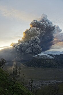
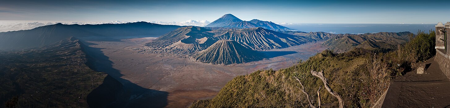
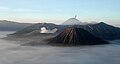
Bromo Tengger Semeru National Park is a national park located in East Java, Indonesia, to the east of Malang and Lumajang, to the south of Pasuruan and Probolinggo, and to the southeast of Surabaya, the capital of East Java. It is the only conservation area in Indonesia that has a sand sea, the Tengger Sand Sea, across which is the caldera of an ancient volcano (Tengger) from which four new volcanic cones have emerged. This unique feature covers a total area of 5,250 hectares at an altitude of about 2,100 meters (6,900 ft). The massif also contains the highest mountain in Java, Mount Semeru, four lakes and 50 rivers. It is named after the Tenggerese people. The explosion of the volcano that created the caldera, happened ca. 45.000 years ago, in an event similar to the Krakatau eruption.
In late October 2010, Mount Merapi in border of Central Java and Special Region of Yogyakarta, Indonesia began an increasingly violent series of eruptions that continued into November. Seismic activity around the volcano increased from mid-September onwards, culminating in repeated outbursts of lava and volcanic ash. Large eruption columns formed, causing numerous pyroclastic flows down the heavily populated slopes of the volcano. The 2010 eruption of Merapi was the volcano's largest since 1872.
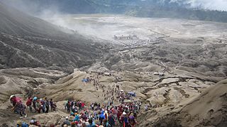
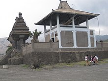
Yadnya Kasada, also known as Kesodo, is a traditional Hindu ritual of the Tenggerese people, an ethnic subgroup of the Javanese. The ritual serves as a way of expressing appreciation to their gods, whom they believe have granted them with blessings, abundance, and welfare.
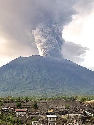
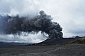
Mount Agung, a volcano on the island of Bali in Indonesia, erupted five times in late November 2017, causing thousands to evacuate, disrupting air travel and causing environmental damage. As of 27 November 2017, the alert level was at its highest and evacuation orders were in place.
Mount Batok is a cinder cone located in East Java, Indonesia. This volcano has an elevation of 2,440 metres (8,005 ft) above sea level, and is located between four regencies: Probolinggo Regency, Pasuruan Regency, Lumajang Regency, and Malang Regency. The location of Mount Batok is west from Mount Bromo. This mountain is one of the inactive volcanoes located within the Tengger caldera. Mount Batok is part of Bromo Tengger Semeru National Park.
{{cite web}}
: Missing or empty |url=
(help)