
Volcanology is the study of volcanoes, lava, magma and related geological, geophysical and geochemical phenomena (volcanism). The term volcanology is derived from the Latin word vulcan. Vulcan was the ancient Roman god of fire.

Bradyseism is the gradual uplift or descent of part of the Earth's surface caused by the filling or emptying of an underground magma chamber or hydrothermal activity, particularly in volcanic calderas. It can persist for millennia in between eruptions and each uplift event is normally accompanied by thousands of small to moderate earthquakes. The word derives from the ancient Greek words βραδύςbradús, meaning "slow", and σεισμόςseismós meaning "movement", and was coined by Arturo Issel in 1883.

Eyjafjallajökull, sometimes referred to by the numeronym E15, is one of the smaller ice caps of Iceland, north of Skógar and west of Mýrdalsjökull. The ice cap covers the caldera of a volcano with a summit elevation of 1,651 metres (5,417 ft). The volcano has erupted relatively frequently since the Last Glacial Period, most recently in 2010, when, although relatively small for a volcanic eruption, it caused enormous disruption to air travel across northern and western Europe for a week.
A volcano tectonic earthquake or volcano earthquake is caused by the movement of magma beneath the surface of the Earth. The movement results in pressure changes where the rock around the magma has a change in stress. At some point, this stress can cause the rock to break or move. This seismic activity is used by scientists to monitor volcanoes. The earthquakes may also be related to dike intrusion and/or occur as earthquake swarms. Usually they are characterised by high seismic frequency and lack the pattern of a main shock followed by a decaying aftershock distribution of fault related tectonic earthquakes.

A harmonic tremor is a sustained release of seismic and infrasonic energy typically associated with the underground movement of magma, the venting of volcanic gases from magma, or both in volcanoes, and with repetitive stick-slip or other impulsive activity in non-volcanic systems. It is a long-duration release of seismic energy, often containing distinct spectral lines. Volcanic tremor often precedes or accompanies a volcanic eruption. Being a long-duration continuous signal from a temporally extended source tremor contrasts distinctly with transient and often impulsive sources of seismic radiation typically associated with earthquakes and explosions.

Aira Caldera is a gigantic volcanic caldera located on the southern end of Kyushu, Japan. It is believed to have been formed about 30,000 years ago with a succession of pyroclastic surges. It is currently the place of residence to over 900,000 people. The shores of Aira Caldera are home to rare flora and fauna, including Japanese bay tree and Japanese black pine. The caldera is home to Mount Sakurajima, and the Mount Kirishima group of stratovolcanoes lies to the north of the caldera. The most famous and active of this group is Shinmoedake.

Prediction of volcanic activity, and volcanic eruption forecasting, is an interdisciplinary monitoring and research effort to predict the time and severity of a volcano's eruption. Of particular importance is the prediction of hazardous eruptions that could lead to catastrophic loss of life, property, and disruption of human activities.
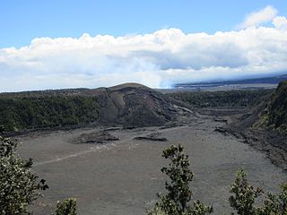
Kīlauea Iki is a pit crater that is next to the main summit caldera of Kīlauea on the island of Hawaiʻi in the Hawaiian Islands. It is known for its eruption in 1959 that started on November 14 and ended on December 20, producing lava fountaining up to 1900 feet and a lava lake in the crater. Today, the surface of the lava lake has cooled and it is now a popular hiking destination to view the aftermath of an eruption.

Nazko Cone is a small potentially active basaltic cinder cone in central British Columbia, Canada, located 75 km west of Quesnel and 150 kilometers southwest of Prince George. It is considered the easternmost volcano in the Anahim Volcanic Belt. The small tree-covered cone rises 120 m above the Chilcotin-Nechako Plateau and rests on glacial till. It was formed in three episodes of activity, the first of which took place during the Pleistocene interglacial stage about 340,000 years ago. The second stage produced a large hyaloclastite scoria mound erupted beneath the Cordilleran Ice Sheet during the Pleistocene. Its last eruption produced two small lava flows that traveled 1 km to the west, along with a blanket of volcanic ash that extends several km to the north and east of the cone.

The Silverthrone Caldera is a potentially active caldera complex in southwestern British Columbia, Canada, located over 350 kilometres (220 mi) northwest of the city of Vancouver and about 50 kilometres (31 mi) west of Mount Waddington in the Pacific Ranges of the Coast Mountains. The caldera is one of the largest of the few calderas in western Canada, measuring about 30 kilometres (19 mi) long (north-south) and 20 kilometres (12 mi) wide (east-west). Mount Silverthrone, an eroded lava dome on the caldera's northern flank, which is 2,864 metres (9,396 ft) high, may be the highest volcano in Canada.
A series of small volcanic earthquakes measuring less than 4.0 on the Richter magnitude scale took place in the sparsely populated Nazko area of the Central Interior of British Columbia, Canada, from October 9, 2007, to June 12, 2008. They occurred just west of Nazko Cone, a small tree-covered cinder cone that last erupted about 7,200 years ago.

A volcanic hazard is the probability a volcanic eruption or related geophysical event will occur in a given geographic area and within a specified window of time. The risk that can be associated with a volcanic hazard depends on the proximity and vulnerability of an asset or a population of people near to where a volcanic event might occur.
The 2011–2012 El Hierro eruption occurred just off the island of El Hierro, the second smallest and farthest south and west of the Canary Islands, in the Atlantic Ocean off the coast of Africa. The island is also the youngest in the volcanic chain. The October 2011 – March 2012 eruption was underwater, with a fissure of vents located approximately 2 kilometres to the south of the fishing village of La Restinga on the southern coast of the island. Increased seismicity in June 2012 to the north-west of the vent did not result in another phase of eruptive activity. Until the 2021 La Palma eruption, which started on 19 September 2021, this was the last volcanic eruption in Spain.
Volcano tectonics is a scientific field that uses the techniques and methods of structural geology, tectonics, and physics to analyse and interpret physical processes and the associated deformation in volcanic areas, at any scale.
Irruputuncu is a volcano in the commune of Pica, Tamarugal Province, Tarapacá Region, Chile, as well as San Pedro de Quemes Municipality, Nor Lípez Province, Potosí Department, Bolivia. The mountain's summit is 5,163 m (16,939 ft) high and has two summit craters—the southernmost 200 m (660 ft)-wide one has active fumaroles. The volcano also features lava flows, block and ash flows and several lava domes. The volcano is part of the Andean Central Volcanic Zone (CVZ).

The geological deformation of Iceland is the way that the rocks of the island of Iceland are changing due to tectonic forces. The geological deformation help to explain the location of earthquakes, volcanoes, fissures, and the shape of the island. Iceland is the largest landmass situated on an oceanic ridge. It is an elevated plateau of the sea floor, situated at the crossing of the Mid-Atlantic Ridge and the Greenland-Iceland-Scotland ridge. It lies along the oceanic divergent plate boundary of North American Plate and Eurasian Plate. The western part of Iceland sits on the North American Plate and the eastern part sits on the Eurasian Plate. The Reykjanes Ridge of the Mid-Atlantic ridge system in this region crosses the island from southwest and connects to the Kolbeinsey Ridge in the northeast.

A sector collapse or lateral collapse is the structural failure and subsequent collapse of part of a volcano. Unlike a flank collapse, a sector collapse involves the central volcanic pipe. Sector collapses are one of the most hazardous volcanic events, often resulting in lateral blasts, landslides, and changes in volcanic eruptive behavior. Sector collapse can be caused by earthquakes, volcanic eruptions, gradual volcanic deformation, and other processes. Sector collapse events can occur on volcanoes at convergent and divergent plate boundaries. Sector collapses are generally very sudden; however, some attempts have been made to predict collapse events.

Hazel Rymer is a British volcanologist and pro-vice chancellor at the Open University. Her research investigates how active volcanoes affect their environment and impact global climate change. She leads the citizen science project Earth Watch.
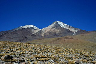
Uturuncu is a dormant volcano in the Sur Lípez Province of Bolivia. It is 6,008 metres (19,711 ft) high, has two summit peaks, and consists of a complex of lava domes and lava flows with a total volume estimated to be 50–85 km3. It bears traces of a former glaciation, even though it does not currently carry glaciers. Volcanic activity took place during the Pleistocene epoch and the last eruption was 250,000 years ago; since then Uturuncu has not erupted but active fumaroles occur in the summit region, between the two summits.
Lazufre is a Quaternary volcanic dome in the central Andes, on the border between Chile and Argentina. It is part of the Central Volcanic Zone (CVZ), one of the four distinct volcanic belts of South America. The CVZ includes a number of calderas and supervolcanoes that have emplaced ignimbrites in the region.


