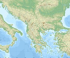
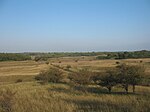
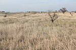
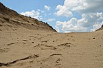
The Deliblato Sands is the largest sandy terrain in Europe, once part of a vast prehistoric desert, having originated from the withdrawal of the Pannonian Sea. They are home to many endemic species of plants and animals which are rare or endangered in Europe and globally. Due to its forest and surroundings, it was declared a special nature reserve. On a national level, it represents a natural asset of special importance falling under protection category I.
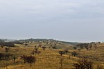
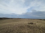
The Deliblato is an expanse of Aeolian processes with significant dune-like relief made of powerful sandy deposits. It is a unique feature in this part of the world as the largest exemplar of the true sandy relief. Dunes are 70 to 200m (230 to 660ft) tall.[1] Southeast of the sands is the Kraljevac lake, one of the reservoirs formed around the edges of the region, in an effort to stop moving of the sand. There are floating peat islands on the lake's surface, where numerous waterfowls are nesting.[2]
Southern section of the sands, which reaches the Danube, is known as the Labudovo Okno. It has been declared a Ramsar wetland in 2006. The section covers an area of some 40km2 (15sqmi) and includes marshes, ponds, meanders, river islands of Žilovo, Čibuklija and Zavojska Ada, meanders of the Karaš river and the submerged mouth of the Nera into the Danube. It is one of the most important migratory birds habitats in Serbia.[1]
Remains from the Bronze Age were discovered in the locality of Židovar. Other localities (Đurica, Grebenac, Veliki Grad, Mali Grad) contain remains of the habitation from the 13th century BC to the 1500s and 1600s. Roman period is represented with the trench near Kovin (Rimski šanac).[1]
In 1789, Austrian authorities, which controlled the area at the time, dispatched forest engineer Franz Bachofen from Timișoara to conduct measurements of the sands and complies a report on how to "tame" the sand. At the time, strong winds and storms would carry the sand from Deliblato all the way to Vienna and Pest.[1] According to the popular myth, Austrian empress Maria Theresa ordered for the fixing of Deliblato after wind brought some sand into her plate while she was eating soup.[2] After a decade of work, Bachofen reported that the sands cover an area of 406.60km2 (156.99sqmi), out of which 168km2 (65sqmi) is covered with loose, free sand. In order to immobilize the sand, Bachofer drafter a forestation plan, which was accepted in 1818. Since then, almost 300km2 (120sqmi) of the sands was forested, but also 250km2 (97sqmi) got burned in time in three catastrophic fires caused by the human negligence.[1]
The sand was used as a hideout by the Yugoslav Partisans during World War II. They used to build base camps and dugouts where they were hiding after the anti-German actions. Out of numerous temporary hideouts, only one is preserved today. It was an improvised hospital at the locality Čardak. A monument dedicated to the Jews who were transported from Belgrade and executed in the sands by the Germans during the occupation, is also located here.[1]
After the war, numerous Youth work actions were organized in the sands. Until the late 1980s, organized and planned works included immobilization of the sand, formation of the firefighting paths and paving the roads, while the "Čardak" settlement for the participants of the actions was constructed. It was envisioned as a touristic and sports complex in the future, but it was neglected in time and since the 1990s became a settlement for the Yugoslav wars refugees.[1] The greenery in the region was almost completely destroyed in the devastating 1996 fire.[2]
"Čardak" was then adapted into the educational-recreational center. In March 2020, the provincial administration decided to use it as the camp for the Middle Eastern migrants, who at the time numbered 8,500, scattered in 17 camps all over Serbia. Only those from Vojvodina (several hundreds) were to be placed here. Hundreds of local denizens protested, joined by the representatives of the local administration. Though claiming the decision was only temporary (2 months at most), the province revoked it a week later, declaring it the COVID-19 quarantine instead.[4]
In total there are some 800 households, weekend-houses or rooms in excursion complexes in the sands. This includes a weekend settlement with 20 bungalows, built by the former Glass Industry Pančevo, which is today left to the elements. The chronic problem in the sands is the lack of drinking water.[5]
Characteristics
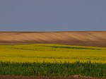
Extensive grapevine cultivation spread while the sands were part of the Banat Military Frontier, until 1873. It was said that "there was no house without a grapevine" at the time. There were also large vineyard plantations, like the Pálfi and Sauerwald at Kajtasovo, Emanuelovac at Dubovac, Wekerle at Vladimirovac, Mramorak Vineyards and the vineyard at Šušara. The red grape was dominant (varieties of Othello, Trollinger, Sazodoš and Volovo Oko), but also cultivated were the white grape (White Othello, Kozje Sise) and the rose grape (Dinka). As the cultivation of vines on the sandy soil is an arduous work, many quit cultivation in time, leaving vast empty sand areas.[1]
Locality of Devojački Bunar is situated in the northwestern corner of the sands. It is a popular excursion place which also includes the only wooden church in Vojvodina, dedicated to Margaret the Virgin, in Serbian known as the Fiery Maria, and an old dolap. Dolap is a type of old water well, powered by animals, mostly horses or oxen. The well at Devojački Bunar extracted water from the depth of 163m (535ft).[1]
An artistic colony "Deliblatska Peščara" is organized annually. In decades, until 2019, 432 artists participated in workshops, producing thousands of works, out of which 1,288 were given to the town of Pančevo.[1] Established in 1969, the colony is centered at Devojački Bunar.[6]
Serbia is a small country situated at the crossroads of Central and Southeast Europe, covering the far southern edges of the Pannonian Plain and the central Balkans. It shares borders with Bosnia and Herzegovina, Bulgaria, Croatia, Hungary, North Macedonia, Montenegro, and Romania. Serbia shares a contested border with Albania as it doesn't recognise the independence of Kosovo. Serbia is landlocked, though it is able to access the Adriatic Sea through Montenegro and inland Europe and the Black Sea via the Danube.
County of Temes was an administrative county (comitatus) of the Kingdom of Hungary. Its territory is now in southwestern Romania and northeastern Serbia. The capital of the county was Temesvár, which also served as the kingdom's capital between 1315–1323.
The Timiș or Tamiš is a 359-kilometre-long (223 mi) river that flows through the Banat region of Romania and Serbia and joins the Danube near Pančevo, in northern Serbia. Due to its position in the region, it has been labeled as the "spine of the Banat".
New Serbia or Novoserbia was a military frontier of Imperial Russia from 1752 to 1764 subordinated directly to the Governing Senate and Military Collegium. It was situated in the territory of New Russia. In 1764, the territory became part of the New Russia Governorate.
The Karaš or Caraș is a 110-kilometre (68 mi) long river in the Banat region of Vojvodina, Serbia and Romania and a left tributary of the Danube. The Karaš drains an area of 1,400 square kilometres (540 sq mi) and although it has been channeled it is not navigable.
The Great Hungarian Plain is a plain occupying the majority of the modern territory of Hungary. It is the largest part of the wider Pannonian Plain. Its territory significantly shrank due to its eastern and southern boundaries being adjusted by the new political borders created after World War I when the Treaty of Trianon was signed in 1920.
Kačarevo is a village in northern Serbia, situated in the municipality of Pančevo, South Banat District, Vojvodina province. The village has a Serb ethnic majority and its population numbering 6,346 people.
Ivanovo is a village located in the Pančevo municipality, in the South Banat District of Vojvodina, Serbia. It has a population of 974 inhabitants.
The Nadela or Nadel is a system of canals and rivers in northern Serbia, an 84 km (52 mi) long left tributary to the Danube in the Banat region of the Vojvodina province.
Pančevački Rit is a small geographical area in south-western Banat, Serbia. It is situated between the rivers Danube and Tamiš, in Belgrade's municipality of Palilula.
Banatska Palanka is a village in Serbia. It is situated in the Bela Crkva municipality, South Banat District, Vojvodina province. The population of the village is 837, of whom 752 (89.84%) are ethnic Serbs.
Omoljica is a village located in the municipality of Pančevo, South Banat District, Vojvodina, Serbia. The village population is 6,309 people.
Deliblato is a village in Serbia, situated in the Kovin municipality in the Vojvodina province. The village has a total population of 3,498, with a Serb ethnic majority and a Romanian minority. The Deliblatska Peščara, the largest sandy area in Europe, was named after this village.
The Vršac Mountains, also known as Vršac Hill, are located in the Banat region near the city of Vršac, Serbia, and partially also in Romania. They represent an independent and distinct massif, 19 kilometres (12 mi) long and spreading across an area of 170 km2 (66 sq mi), of which 122 km2 (47 sq mi) belong to Serbia and 48 km2 (19 sq mi) to Romania.
Carska Bara is the largest individual bog in Serbia, in the municipality of Zrenjanin. Along with the neighboring pond of Stari Begej it forms the Special nature reserve "Carska Bara".
Čardak is a former vacation settlement on the southern edge of the Deliblatska peščara, in the community of Kovin in Serbia. It has served as a refugee camp since 1991. The camp is about five km east of the village of Deliblato in the South Banat District.
Subotička Peščara or Subotica Sands is an inland dune habitat located in northern Serbia, along the Hungarian border. The area stretches across the far north of the Bačka region, in the municipality of Subotica. It is protected as a landscape of outstanding features "Subotičko-horgoška peščara", occupying an area of 53.70 km2. Today's undulating sand dunes are a result of the past aeolian activity; the area has been largely forested. The planned forestation of the Subotica Sands began in the late 18th century. Today the habitat constitutes a mix of forest, steppe and wetland. The eastern part of the area is made up of banks of the border river Kereš.
Labudovo okno is a special nature reserve and a Ramsar site in Serbia.
References
1 2 3 4 5 6 7 8 9 10 11 12 13 14 15 Olga Janković (2 June 2019). "Занимљива Србија: Делиблатска пешчара - Немирни песак европске Сахаре" [Interesting Serbia: Deliblatska Peščara - Restless sand of European Sahara]. Politika-Magazin, No. 1131 (in Serbian). pp.20–21.
↑ Olga Janković (28 March 2020). Чардак ипак карантин, а не центар за мигранте[Čardak quarantine after all, not the migrants' center]. Politika (in Serbian). p.17.
↑ Olga Janković (31 July 2022). Пресушио Девојачки бунар[Girls' well dried out]. Politika (in Serbian). p.12.
↑ Olga Janković (20 July 2019). Скраћено издање "Делиблатског песка"[Short edition of "Deliblatski pesak"]. Politika (in Serbian). p.13.
This page is based on this Wikipedia article Text is available under the CC BY-SA 4.0 license; additional terms may apply. Images, videos and audio are available under their respective licenses.