Šalinac Grove

Last updated
Šalinac Grove
Shalinachki lug.jpg
Šalinac Grove
Serbia adm location map.svg
Red pog.svg
Coordinates 44°42′09″N21°02′48″E / 44.702582°N 21.0465431°E / 44.702582; 21.0465431 [1] Coordinates: 44°42′09″N21°02′48″E / 44.702582°N 21.0465431°E / 44.702582; 21.0465431 [2]

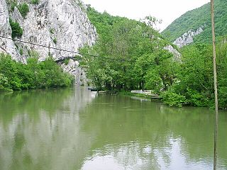
Šalinac Grove (Serbian : Шалиначки луг / Šalinački lug) is a protected area in Serbia which contains the last remnant of the oak-and-ash forests which until several hundred years ago covered the flooded areas in the valleys of the Velika Morava and the Danube. It is a real rarity not only in Serbia but in the wider area of the Balkan peninsula.

Serbian language South Slavic language

Serbian is the standardized variety of the Serbo-Croatian language mainly used by Serbs. It is the official language of Serbia, the territory of Kosovo, and one of the three official languages of Bosnia and Herzegovina. In addition, it is a recognized minority language in Montenegro where it is spoken by the relative majority of the population, as well as in Croatia, North Macedonia, Romania, Hungary, Slovakia, and the Czech Republic.

Protected area location which receives protection because of its recognised natural, ecological or cultural landscape values

Protected areas or conservation areas are locations which receive protection because of their recognized natural, ecological or cultural values. There are several kinds of protected areas, which vary by level of protection depending on the enabling laws of each country or the regulations of the international organizations involved.

Danube river in Central Europe

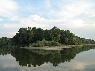
The Danube, known by various names in other languages, is Europe's second longest river, after the Volga. It is located in Central and Eastern Europe.

Wood in Salinac Grove Shalinachki lug - drvo.jpg
Wood in Šalinac Grove

It is situated 10 kilometres (6.2 mi) east of Smederevo, on the vast plain of the Godomin Field (Serbian : Годоминско поље / Godominsko polje); the plain itself came to exist as a result of floods of the river Velika Morava in the area where it flows into the Danube. The grove is surrounded by the settlements of Šalinac and Kulič, and also - in a wide bend - by a former meander of the Velika Morava which is now an oxbow lake.

Smederevo City in Southern and Eastern Serbia, Serbia

Smederevo is a city and the administrative center of the Podunavlje District in eastern Serbia. It is situated on the right bank of the Danube, about 45 kilometres downstream of the capital, Belgrade.

Šalinac Village in Podunavlje, Serbia

Šalinac is a village in the municipality of Smederevo, Serbia. According to the 2002 census, the village has a population of 985 people.

Kulič Village in Podunavlje, Serbia

Kulič is a village in the municipality of Smederevo, Serbia. The settlement is in the period 1959–1997. year was part of the settlement Šalinac, before 1959 it was an independent settlement. Officially recognized as an independent settlement 2011. According to the 2011 census, the village has a population of 232 people.

It contains a tall, homogeneous stand of trees which are almost the same age, including about 200 centennial marsh oak trees (Quercus robur), once accompanied by field ash trees (Fraxinus angustifolia). The protected area covers 19 hectares (47 acres).

<i>Quercus robur</i> species of plant

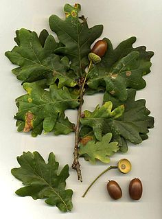
Quercus robur, commonly known as common oak, pedunculate oak, European oak or English oak, is a species of flowering plant in the beech and oak family, Fagaceae. It is native to most of Europe west of the Caucasus. The tree is widely cultivated in temperate regions and has escaped into the wild in scattered parts of China and North America.

<i>Fraxinus angustifolia</i> species of plant

Fraxinus angustifolia, the narrow-leafed ash, is a species of Fraxinus native to central and southern Europe, northwest Africa, and southwest Asia.

The grove's age is estimated at 200–300 years. The average size of the oak trees is:

Height of tree trunks17.58 metres (57.7 ft)
Radius of tree tops15.43 metres (50.6 ft)
Volume of tree trunks4.14 metres (13.6 ft)
Radius of tree trunks1.32 metres (4.3 ft)

Related Research Articles

Geography of Serbia

Serbia is a sovereign state situated at the crossroads of Central and Southeast Europe, covering the far southern edges of the Pannonian Plain (Vojvodina) and the central Balkans. It shares borders with Bosnia-Herzegovina, Bulgaria, Croatia, Hungary, North Macedonia, Montenegro, Romania and Albania through the disputed territory of Kosovo. It is landlocked, although access to the Adriatic Sea is available through Montenegro, and the Danube River provides shipping access to inland Europe and the Black Sea.

Morava (river) river in Central Europe

The Morava is a river in Central Europe, a left tributary of the Danube. It is the main river of Moravia, which derives its name from it. The river originates on the Králický Sněžník mountain in the north-eastern corner of Pardubice Region, near the border between the Czech Republic and Poland and has a vaguely southward trajectory. The lower part of the river's course forms the border between the Czech Republic and Slovakia and then between Austria and Slovakia.

Great Morava river in Serbia

The Great Morava is the final section of the Morava, a major river system in Serbia.

West Morava river in Serbia

West Morava is a river in Central Serbia, a 184 km-long headstream of the Great Morava, which it forms with the South Morava. It was known as Brongos in antiquity.

Grocka Municipality in Belgrade, Serbia

Grocka, or Grocka na Dunavu, is a municipality of the city of Belgrade. According to the 2011 census results, the municipality has 83,907 inhabitants.

Nišava river in Serbia

The Nišava or Nishava is a river in Bulgaria and Serbia, a right tributary, and with a length of 218 km also the longest one, of the South Morava.

Jevremovac Urban neighbourhood in Stari Grad, Belgrade, Serbia

Jevremovac Botanical Garden is the botanical garden of the University of Belgrade and also a surrounding urban neighborhood of Belgrade, the capital of Serbia. The garden is located in Belgrade's municipality of Stari Grad and is an administered by the University of Belgrade's Biology School.

Great War Island Island at the confluence of Sava into Danube

Great War Island is a river island in Belgrade, capital of Serbia. It is located at the confluence of Sava and Danube rivers. Though uninhabited, the island is part of the Belgrade City proper, and belongs to the city municipality of Zemun.

South Morava river

The South Morava is a river in eastern Kosovo and in southern Serbia, which represents the shorter headwater of Great Morava. Today, it is 295 km long, including its source river Binačka Morava. It flows generally in the south to north direction, from Macedonian border to Kosovo and onwards to Central Serbia, where it meets West Morava at Stalać, to create Great Morava.

The Jablanica is an 85-kilometre-long (53 mi) river in southern Serbia. A left tributary of the South Morava river, it gives its name to the region of Jablanica and to modern Serbia's Jablanica District, with the region contributing about one third of the district's area.

Jasenica (river) river in Serbia

The Jasenica is a river in central Serbia. It is 79 kilometres (49 mi) long and is the left tributary of the Great Morava. This river gives the name to the surrounding region.

Vlasina (river) river in Serbia

The Vlasina, is a river in southeastern Serbia, a 70 km-long outflow of the Vlasina Lake and a right tributary to the Južna Morava, which also gives its name to the surrounding Vlasina region.

Morava Valley

The Morava Valley, is a general term which in its widest sense marks valleys of any of three Morava rivers in Serbia: the West Morava, the South Morava and the Great Morava. In the narrow sense, the term is applied only to the Great Morava Valley. The Serbian term follows the general manner of coining river valley names in Serbian using the prefix po- and suffix -je, meaning literally "(land) along the Morava". Morava valley lies in the central Balkans, at the crossroads which lead eastwards, towards the Black sea and Asia Minor, and further south, down the Vardar river into the Aegean sea.

Gornje Podunavlje Protected wetland area in the northwest of Serbia

Gornje Podunavlje Special Nature Reserve is a large protected area of wetland in the northwest of Serbia, on the Danube's left bank. It comprises two large marshes, Monoštorski Rit and Apatinski Rit and vast forests, meadows, ponds, swamps and the Danube's meanders, including 66 km (41 mi) of the Danube course. It is projected as a part of the future trans-boundary biosphere reserve "Mura-Drava-Danube", a five country project, dubbed the "Amazon of Europe".

Drina river, which forms a large portion of the border between Bosnia and Herzegovina and Serbia

The Drina is a 346 km (215 mi) long international river, which forms a large portion of the border between Bosnia and Herzegovina and Serbia. It is the longest tributary of the Sava River and the longest karst river in the Dinaric Alps which belongs to the Danube river watershed. Its name is derived from the Latin name of the river which in turn is derived from Greek.

Willamette Valley (ecoregion)

The Willamette Valley ecoregion is a Level III ecoregion designated by the United States Environmental Protection Agency in the U.S. states of Oregon and Washington. Slightly larger than the Willamette Valley for which it is named, the ecoregion contains fluvial terraces and floodplains of the Willamette River system, scattered hills, buttes, and adjacent foothills. It is distinguished from the neighboring Coast Range, Cascades, and Klamath Mountains ecoregions by lower precipitation, lower elevation, less relief, and a different mosaic of vegetation. Mean annual rainfall is 37 to 60 inches, and summers are generally dry. Historically, the region was covered by rolling prairies, oak savanna, coniferous forests, extensive wetlands, and deciduous riparian forests. Today, it contains the bulk of Oregon's population, industry, commerce, and agriculture. Productive soils and a temperate climate make it one of the most important agricultural areas in Oregon.

Jezava river in Serbia

The Jezava is a river in central Serbia. Formerly a distributary of the Great Morava that flowed into the Danube in Smederevo at the Smederevo Fortress, its upper course was separated from the Great Morava by a dam after floods in 1897. In the 1970s the lower course of the Jezava was diverted into a new stream bed, leading to the Great Morava. The old bed of the Jezava in Smederovo has been retained for drainage of the urban area of Smederovo. The Jezava drains an area of 692 km², belonging to the Black Sea drainage basin.

Labudovo okno

Labudovo okno is a special nature reserve and a Ramsar site in Serbia.

Kremenets Mountains National Nature Park national nature park in Ukraine

Kremenets Mountains National Nature Park covers a cluster of mountains and ridges in the Hologoro-Kremenetskiy range of the Podolian Upland in west central Ukraine. Administratively, the park is in Kremenets District and Shumsk District in Ternopil Oblast.

References