The Miocene is the first geological epoch of the Neogene Period and extends from about 23.03 to 5.333 million years ago (Ma). The Miocene was named by Scottish geologist Charles Lyell; the name comes from the Greek words μείων and καινός and means "less recent" because it has 18% fewer modern marine invertebrates than the Pliocene has. The Miocene is preceded by the Oligocene and is followed by the Pliocene.
The Pliocene is the epoch in the geologic time scale that extends from 5.333 million to 2.58 million years ago. It is the second and most recent epoch of the Neogene Period in the Cenozoic Era. The Pliocene follows the Miocene Epoch and is followed by the Pleistocene Epoch. Prior to the 2009 revision of the geologic time scale, which placed the four most recent major glaciations entirely within the Pleistocene, the Pliocene also included the Gelasian Stage, which lasted from 2.588 to 1.806 million years ago, and is now included in the Pleistocene.

The Tethys OceanTEETH-iss, TETH-, also called the Tethys Sea or the Neo-Tethys, was a prehistoric ocean during much of the Mesozoic Era and early Cenozoic Era, located between the ancient continents of Gondwana and Laurasia, before the opening of the Indian and Atlantic oceans during the Cretaceous Period.

The geology of Great Britain is renowned for its diversity. As a result of its eventful geological history, Great Britain shows a rich variety of landscapes across the constituent countries of England, Wales and Scotland. Rocks of almost all geological ages are represented at outcrop, from the Archaean onwards.

The Laurentide Ice Sheet was a massive sheet of ice that covered millions of square miles, including most of Canada and a large portion of the Northern United States, multiple times during the Quaternary glacial epochs, from 2.58 million years ago to the present.
The Messinian salinity crisis was a geological event during which the Mediterranean Sea went into a cycle of partial or nearly complete desiccation (drying-up) throughout the latter part of the Messinian age of the Miocene epoch, from 5.96 to 5.33 Ma. It ended with the Zanclean flood, when the Atlantic reclaimed the basin.

In biogeography, the Mediterranean Basin, also known as the Mediterranean Region or sometimes Mediterranea, is the region of lands around the Mediterranean Sea that have mostly a Mediterranean climate, with mild to cool, rainy winters and warm to hot, dry summers, which supports characteristic Mediterranean forests, woodlands, and scrub vegetation. It was a very important part of Mediterranean civilizations.
An inland sea is a continental body of water which is very large in area and is either completely surrounded by dry land or connected to an ocean by a river, strait or "arm of the sea". An inland sea will generally have higher salinity than a freshwater lake, but usually lower salinity than seawater. As with other seas, inland seas experience tides governed by the orbits of the Moon and Sun.

The Molasse basin is a foreland basin north of the Alps which formed during the Oligocene and Miocene epochs. The basin formed as a result of the flexure of the European plate under the weight of the orogenic wedge of the Alps that was forming to the south.

The geology of the Rocky Mountains is that of a discontinuous series of mountain ranges with distinct geological origins. Collectively these make up the Rocky Mountains, a mountain system that stretches from Northern British Columbia through central New Mexico and which is part of the great mountain system known as the North American Cordillera.

The geology of England is mainly sedimentary. The youngest rocks are in the south east around London, progressing in age in a north westerly direction. The Tees–Exe line marks the division between younger, softer and low-lying rocks in the south east and the generally older and harder rocks of the north and west which give rise to higher relief in those regions. The geology of England is recognisable in the landscape of its counties, the building materials of its towns and its regional extractive industries.

The geological history of the Earth follows the major geological events in Earth's past based on the geological time scale, a system of chronological measurement based on the study of the planet's rock layers (stratigraphy). Earth formed about 4.54 billion years ago by accretion from the solar nebula, a disk-shaped mass of dust and gas left over from the formation of the Sun, which also created the rest of the Solar System.

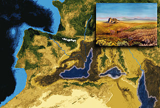
The Paratethys sea, Paratethys ocean, Paratethys realm or just Paratethys was a large shallow inland sea that stretched from the region north of the Alps over Central Europe to the Aral Sea in Central Asia.

The geology of the Iberian Peninsula consists of the study of the rock formations on the Iberian Peninsula, which includes Spain, Portugal, Andorra, and Gibraltar. The peninsula contains rocks from every geological period from the Ediacaran to the Quaternary, and many types of rock are represented. World-class mineral deposits are also found there.
This is a list of articles related to plate tectonics and tectonic plates.
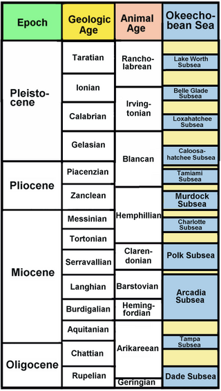
The Okeechobean Sea was a Cenozoic eutropical subsea, which along with the Choctaw Sea, occupied the eastern Gulf of Mexico basin system bounding Florida.

Orcinus meyeri is a fossil species of Orcinus found in the Early Miocene deposits of southern Germany, known from two jaw fragments and 18 isolated teeth. It was originally described as Delphinus acutidens in 1859, but reclassified in 1873. Its validity is disputed, and it may be a synonymous with the ancient sperm whale Physeterula dubusi. It was found in the Alpine town of Stockach in the Molasse basin, which was a coastal area with strong tidal currents.

The geology of Sudan formed primarily in the Precambrian, as igneous and metamorphic crystalline basement rock. Ancient terranes and inliers were intruded with granites, granitoids as well as volcanic rocks. Units of all types were deformed, reactivated, intruded and metamorphosed during the Proterozoic Pan-African orogeny. Dramatic sheet flow erosion prevented almost any sedimentary rocks from forming during the Paleozoic and Mesozoic. From the Mesozoic into the Cenozoic the formation of the Red Sea depression and complex faulting led to massive sediment deposition in some locations and regional volcanism. Sudan has petroleum, chromite, salt, gold, limestone and other natural resources.
The geology of Austria consists of Precambrian rocks and minerals together with younger marine sedimentary rocks uplifted by the Alpine orogeny.

The geology of the State of New York is made up of ancient Precambrian crystalline basement rock, forming the Adirondack Mountains and the bedrock of much of the state. These rocks experienced numerous deformations during mountain building events and much of the region was flooded by shallow seas depositing thick sequences of sedimentary rock during the Paleozoic. Fewer rocks have deposited since the Mesozoic as several kilometers of rock have eroded into the continental shelf and Atlantic coastal plain, although volcanic and sedimentary rocks in the Newark Basin are a prominent fossil-bearing feature near New York City from the Mesozoic rifting of the supercontinent Pangea.

