Kopaonik is a mountain range located in Kosovo and Serbia. The highest point of this mountain range is the Pančić's Peak with an altitude of 2,017 m (6,617 ft). The central part of the Kopaonik plateau was declared a national park in 1981 which today covers an area of 121.06 km2 (46.74 sq mi).

Suva Planina is a mountain in southeastern Serbia. It lies between the towns of Niška Banja to the northwest and Babušnica to the southeast, with a ridge branching towards Bela Palanka to the north. It was previously called Kunovica.

Rudnik is a mountain in central Serbia, near the town of Gornji Milanovac. Its highest peak Cvijićev vrh, named after geologist and biologist Jovan Cvijić, has an elevation of 1,132 meters above sea level. It has several other peaks over 1000 m: Srednji Šturac, Mali Šturac, Molitve, Paljevine and Marijanac. Rudnik literally means 'mine' in Serbian, apparently referring to the mountain's rich mineral resources. The name is probably a testament to the mining activity associated with the mountain throughout several millennia.

Radan is a mountain in southern Serbia, 33 km from the town of Kuršumlija. Its highest peak, Šopot, has an elevation of 1,408 meters above sea level.

Golija is a mountain in southwestern Serbia, between towns of Ivanjica and Novi Pazar. It is part of the Dinaric mountain range. The mountain is heavily forested with significant biodiversity. It contains the Golija-Studenica Biosphere Reserve, the first UNESCO-MAB registered biosphere reserve in Serbia. It is also a small ski resort, with several historical monuments and monasteries. The highest peak is Jankov Kamen at 1,833 metres (6,014 ft).

Besna Kobila is a mountain in southeastern Serbia and small ski center. Its eponymous highest peak has an elevation of 1,923 m. It lies 35 km to the east of the city of Vranje. There is a mountain chalet Besna Kobila from where it takes between 60 and 90 minutes to reach the summit on foot. The mountain is known for its stormy weather, so the best months for climbing are during the warmer part of the year.

Čemernik is a mountain in southeastern Serbia, near the town of Surdulica. Its highest peak Vrlo osoje has an elevation of 1,638 m (5,374 ft) above sea level. It is one of mountains that surround the Vlasina plateau and the Vlasina Lake.

Čemerno is a mountain in western Serbia, near the town of Ivanjica. Its highest peak Smrdljuč has an elevation of 1,579 m (5,180 ft) above sea level.

Deli Jovan is a mountain in eastern Serbia, near the town of Negotin. Its highest peak Crni vrh has an elevation of 1,141 m (3,743 ft) above sea level. On the top of the mountain, there is a TV tower.

Mučanj is a mountain in western Serbia, near the town of Ivanjica. Its highest peak Klekov Vrh has an elevation of 1,534 meters (5,033 ft).

Zlatar is a mountain range in southwestern Serbia, lying between towns of Prijepolje and Nova Varoš. Its highest peak is Velika krseva, 1,627 meters tall, peak next to Golo brdo. It belongs to Stari Vlah group of Dinaric Alps. Zlatar is bounded by rivers Uvac, Lim, Mileševka and Bistrica, and has a total of four artificial lakes – Zlatar Lake, Radoinjsko Lake, Uvac Lake and Potpeć. Mountainous climate with significant mediterranean influence, dense pine forests, and a high number of sunny days, is suitable for medicinal purposes and altitude training. At the elevation of 1,237 meters, there is a Special Rehabilitation Hospital "Zlatar" with 330 beds.
Blagaja is a mountain in central Serbia, near the town of Požega. Its highest peak Ravni krš has an elevation of 844 m (2,769 ft) above sea level.

Crni Vrh is a mountain in central Serbia, near the city of Jagodina. Its highest peak Crni vrh has an elevation of 707 m (2,320 ft) above sea level. It is a small ski resort, with a mountaineering hut at the top, and two tracks of around 750 meters each.
Bukovik is a mountain in central Serbia, between the towns of Ražanj and Aleksinac. Its highest peak Bukova glava has an elevation of 894 m (2,933 ft) above sea level.

Dukat is a mountain in southeastern Serbia, near the town of Bosilegrad. Its highest peak Crnook has an elevation of 1,881 m (6,171 ft) above sea level.
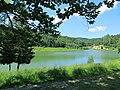
Rožanj is a mountain in central Serbia, near the town of Ražanj. Its highest peak Veliki vrh has an elevation of 897 meters above sea level. It is practically merged with Bukovik mountain, and they are separated only by the pass Baraka (603 m). Lake Bovan is located on the southern foothills of the mountain.
Studena planina is a mountain in central Serbia, near the city of Kraljevo. Its highest peak Kavgalija has an elevation of 1,355 meters above sea level. It stretches from west to east from the Ibar river valley towards the mountain of Goč, forming a continuous ridge with Ravna planina.

Suvobor is a mountain in central Serbia, near the town of Gornji Milanovac. Its highest peak Suvobor has an elevation of 866 m (2,841 ft) above sea level.
Bitovik is a mountain in southwestern Serbia, above the village of Bistrica. Its highest peak has an elevation of 1,371 m (4,498 ft) above sea level.