Platičevo is a village in Serbia. It is located in the Ruma municipality, in the Srem District, Vojvodina province. The village has a Serb ethnic majority and its population numbering 2,760 people.
Gorjani is a village located in the Užice municipality of Serbia. In the 2002 census, the village had a population of 735.

Kačer is a village located in the Užice municipality of Serbia. In the 2002 census, the village had a population of 507.
Krvavci is a village located in the Užice municipality of Serbia. In the 2002 census, the village had a population of 311.

Ljubanje is a village located in the Užice municipality of Serbia. In the 2002 census, the village had a population of 708.
Potočanje is a village located in the Užice municipality of Serbia. In the 2002 census, the village had a population of 564.
Grab is a village in the municipality of Lučani, Serbia. According to the 2011 census, the village has a population of 242 people.
Gostilje is a village in the municipality of Čajetina, western Serbia. According to the 2011 census, the village has a population of 242 people.
Rožanstvo is a village in the municipality of Čajetina, western Serbia. According to the 2011 census, the village has a population of 387 people.
Tripkova is a village in the municipality of Čajetina, western Serbia. According to the 2011 census, the village has a population of 303 people.
Burađa is a village in the municipality of Nova Varoš, western Serbia. According to the 2002 census, the village has a population of 258 people.
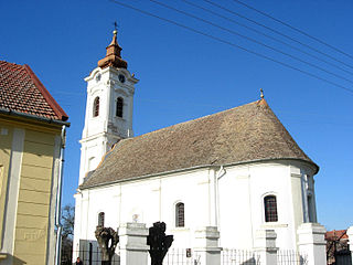
Gorobilje is a village in the municipality of Požega, western Serbia. According to the 2002 census, the village has a population of 1506 people. There is a Serbian Orthodox Church of Saint John the Baptist in the village square.
Prilipac is a village in the municipality of Požega, western Serbia. According to the 2002 census, the village has a population of 341 people.

Čukojevac is a village in the municipality of Kraljevo, western-central Serbia. According to the 2002 census, the village has a population of 1204 people.
Zahumsko is a village in the municipality of Sjenica, Serbia. According to the 2002 census, the village has a population of 150 people.
Ostra Glava is a village in the municipality of Vranje, Serbia. According to the 2002 census, the village has a population of 72 people.
Lađevci is a village situated in Kraljevo municipality in Serbia. According to the 2002 census, the village has a population of 1,258 people.
Petropolje is a village situated in Kraljevo municipality in Serbia.
Muškovina is a village in the municipality of Prijepolje, Serbia. According to the 2002 census, the village has a population of 34 people.
Podunavci is a village in the municipality of Vrnjačka Banja, Serbia. According to the 2011 census, the village has a population of 1,502 people.
