The Sharon plain is the central section of the Coastal Plain of Israel. The Plain lies between the Mediterranean Sea to the west and the Samarian Hills, 15 km (9.3 mi) to the east. It stretches from Nahal Taninim, a stream marking the southern end of Mount Carmel in the north, to the Yarkon River in the south, at the northern limit of Tel Aviv, over a total of about 90 km (56 mi). Parts of the Plain are included in the Central, and Tel Aviv Districts of Israel.

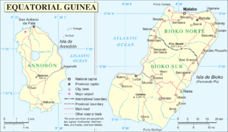
The Insular Region of Equatorial Guinea comprises the former Spanish territory of Fernando Po, together with Annobón island, the latter formerly part of the Spanish territory of Elobey, Annobón and Corisco, which was located in the Gulf of Guinea and in the Corisco Bay.

Gorica is a village in Herzegovina, in Čapljina municipality, Federation of Bosnia and Herzegovina, Bosnia and Herzegovina.

Zalesie is a village in the administrative district of Gmina Rogowo, within Żnin County, Kuyavian-Pomeranian Voivodeship, in north-central Poland. It lies approximately 6 kilometres (4 mi) south-east of Rogowo, 17 km (11 mi) south of Żnin, and 50 km (31 mi) south of Bydgoszcz.

Kozłówka is a village in the administrative district of Gmina Rajgród, within Grajewo County, Podlaskie Voivodeship, in north-eastern Poland. It lies approximately 8 kilometres (5 mi) south of Rajgród, 17 km (11 mi) east of Grajewo, and 69 km (43 mi) north-west of the regional capital Białystok.

Jagodniki is a village in the administrative district of Gmina Dubicze Cerkiewne, within Hajnówka County, Podlaskie Voivodeship, in north-eastern Poland, close to the border with Belarus. It lies approximately 8 kilometres (5 mi) north-east of Dubicze Cerkiewne, 6 km (4 mi) south-west of Hajnówka, and 52 km (32 mi) south-east of the regional capital Białystok.

Michnówka is a village in the administrative district of Gmina Narewka, within Hajnówka County, Podlaskie Voivodeship, in north-eastern Poland, close to the border with Belarus. It lies approximately 10 kilometres (6 mi) north-west of Narewka, 23 km (14 mi) north-east of Hajnówka, and 43 km (27 mi) south-east of the regional capital Białystok.

Klepacze is a village in the administrative district of Gmina Drohiczyn, within Siemiatycze County, Podlaskie Voivodeship, in north-eastern Poland. It lies approximately 12 kilometres (7 mi) north of Drohiczyn, 14 km (9 mi) north-west of Siemiatycze, and 76 km (47 mi) south-west of the regional capital Białystok.

Bukowiec is a village in the administrative district of Gmina Żelechlinek, within Tomaszów Mazowiecki County, Łódź Voivodeship, in central Poland. It lies approximately 3 kilometres (2 mi) south-east of Żelechlinek, 21 km (13 mi) north of Tomaszów Mazowiecki, and 43 km (27 mi) east of the regional capital Łódź.

Rokitnica is a village in the administrative district of Gmina Nowe Miasto nad Pilicą, within Grójec County, Masovian Voivodeship, in east-central Poland. It lies approximately 9 kilometres (6 mi) north-west of Nowe Miasto nad Pilicą, 33 km (21 mi) south-west of Grójec, and 69 km (43 mi) south-west of Warsaw.

Falbogi Wielkie is a village in the administrative district of Gmina Załuski, within Płońsk County, Masovian Voivodeship, in east-central Poland. It lies approximately 5 kilometres (3 mi) east of Załuski, 21 km (13 mi) south-east of Płońsk, and 43 km (27 mi) north-west of Warsaw.

Starowola is a village in the administrative district of Gmina Jadów, within Wołomin County, Masovian Voivodeship, in east-central Poland. It lies approximately 6 kilometres (4 mi) north-east of Jadów, 36 km (22 mi) north-east of Wołomin, and 58 km (36 mi) north-east of Warsaw.

Grabce Józefpolskie is a village in the administrative district of Gmina Mszczonów, within Żyrardów County, Masovian Voivodeship, in east-central Poland. It lies approximately 3 kilometres (2 mi) north-west of Mszczonów, 9 km (6 mi) south-east of Żyrardów, and 43 km (27 mi) south-west of Warsaw.

Maszewko is a village in the administrative district of Gmina Wicko, within Lębork County, Pomeranian Voivodeship, in northern Poland. It lies approximately 6 kilometres (4 mi) east of Wicko, 14 km (9 mi) north of Lębork, and 69 km (43 mi) north-west of the regional capital Gdańsk.

Klejdyty is a village in the administrative district of Gmina Kiwity, within Lidzbark County, Warmian-Masurian Voivodeship, in northern Poland. It lies approximately 8 kilometres (5 mi) north-west of Kiwity, 9 km (6 mi) north-east of Lidzbark Warmiński, and 43 km (27 mi) north of the regional capital Olsztyn.
Sočice is a village in the municipality of Priboj, Serbia. According to the 2002 census, the village has a population of 269 people.
Adilabad Assembly constituency is a constituency of Telangana Legislative Assembly, India. It is one of the two constituencies in Adilabad district, Telangana. It comes under Adilabad Lok Sabha constituency along with 6 other Assembly constituencies.
Burunköy is a village in the District of Söke, Aydın Province, Turkey. In 2010 it had a population of 903.
Hlevene is a village in Lovech Municipality, Lovech Province, northern Bulgaria.
Leshnitsa is a village in Lovech Municipality, Lovech Province, northern Bulgaria.


