
Sulawesi, also known as Celebes, is an island in Indonesia. One of the four Greater Sunda Islands, and the world's 11th-largest island, it is situated east of Borneo, west of the Maluku Islands, and south of Mindanao and the Sulu Archipelago. Within Indonesia, only Sumatra, Borneo, and Papua are larger in territory, and only Java and Sumatra are more populous.

The Philippine Sea is a marginal sea of the Western Pacific Ocean east of the Philippine Archipelago and the largest sea in the world, occupying an estimated surface area of 5 million square kilometers. The Philippine Sea Plate forms the floor of the sea. Its western border is the first island chain to the west, comprising the Ryukyu Islands in the northwest and Taiwan in the west. Its southwestern border comprises the Philippine islands of Luzon, Catanduanes, Samar, Leyte, and Mindanao. Its northern border comprises the Japanese islands of Honshu, Shikoku and Kyūshū. Its eastern border is the second island chain to the east, comprising the Bonin Islands and Iwo Jima in the northeast, the Mariana Islands in the due east, and Halmahera, Palau, Yap and Ulithi in the southeast. Its southern border is Indonesia's Morotai Island.

The Celebes Sea or Sulawesi Sea of the western Pacific Ocean is bordered on the north by the Sulu Archipelago and Sulu Sea and Mindanao Island of the Philippines, on the east by the Sangihe Islands chain, on the south by Sulawesi's Minahasa Peninsula, and the west by northern Kalimantan in Indonesia. It extends 420 miles (675 km) north-south by 520 mi (840 km) east-west and has a total surface area of 110,000 square miles (280,000 km2), to a maximum depth of 20,300 feet (6,200 m). South of the Cape Mangkalihat, the sea opens southwest through the Makassar Strait into the Java Sea.

The Rock Islands of Palau, also called Chelbacheb, are a collection of several hundred small limestone or coral uprises in the Southern Lagoon of Palau between Koror and Peleliu, now an incorporated part of Koror State. There are between 250 and 300 islands in the group according to different sources, with an aggregate area of 42 square kilometers (16 sq mi) and a maximum height of 207 meters (679 ft). The islands were declared a UNESCO World Heritage Site in 2012.

Baa Atoll is an administrative division of the Maldives. It consists of three separate natural atolls, namely southern Maalhosmadulu Atoll, the Fasdūtherē Atoll and the smaller natural atoll known as Goifulhafehendhu Atoll.

The Togian Islands are an archipelago of 56 islands and many offshore islets, situated in the Gulf of Tomini, off the coast of Central Sulawesi, in Indonesia. The largest islands are Batudaka, Togean, Talatako, Una-Una, Walea Bahi, Walea Kodi and Malenge. There are 59 villages on the islands, with one settled by the Bajau people, more commonly known as the sea gypsies.
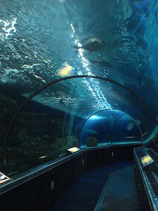
Sea Life at Mall of America is a public aquarium located in the Mall of America in Bloomington, Minnesota, United States. The 1.3 million-US-gallon aquarium contains thousands of aquatic creatures, including sea turtles, sharks, sawfish, stingrays, jellyfish and seahorses. There are eleven exhibits featured at the aquarium. The aquarium is highlighted by a 300-foot (91 m) 360° clear acrylic tunnel, which consists of four different areas housing both freshwater and salt water creatures.
Kakaban island is part of the Derawan Islands, East Kalimantan, Indonesia.
The fauna of Indonesia is characterised by high levels of biodiversity and endemicity due to its distribution over a vast tropical archipelago. Indonesia divides into two ecological regions; western Indonesia which is more influenced by Asian fauna, and the east which is more influenced by Australasian species.

Raja Ampat, or the Four Kings, is an archipelago located off of the northwest tip of Bird's Head Peninsula, Southwest Papua province, Indonesia. It comprises over 1,500 small islands, cays, and shoals around the four main islands of Misool, Salawati, Batanta, and Waigeo, and the smaller island of Kofiau.
Berau Regency is the most northern of the seven regencies in East Kalimantan province in Indonesia. The capital is the town of Tanjung Redeb. The regency has an area of 36,962.37 km2 and had a population of 179,079 at the 2010 census and 248,035 at the 2020 census; the official estimate as at mid 2023 was 280,998.

The Coral Triangle (CT) is a roughly triangular area in the tropical waters around Indonesia, Malaysia, Papua New Guinea, the Philippines, Solomon Islands, and Timor-Leste. This area contains at least 500 species of reef-building corals in each ecoregion. The Coral Triangle is located between the Pacific and Indian oceans and encompasses portions of two biogeographic regions: the Indonesian-Philippines Region, and the Far Southwestern Pacific Region. As one of eight major coral reef zones in the world, the Coral Triangle is recognized as a global centre of marine biodiversity and a global priority for conservation. Its biological resources make it a global hotspot of marine biodiversity. Known as the "Amazon of the seas", it covers 5.7 million square kilometres (2,200,000 sq mi) of ocean waters. It contains more than 76% of the world's shallow-water reef-building coral species, 37% of its reef fish species, 50% of its razor clam species, six out of seven of the world's sea turtle species, and the world's largest mangrove forest. The epicenter of that coral diversity is found in the Bird’s Head Seascape of Indonesian Papua, which hosts 574 species. Within the Bird’s Head Seascape, the Raja Ampat archipelago is the world’s coral diversity bull’s eye with 553 species. In 2014, the Asian Development Bank (ADB) reported that the gross domestic product of the marine ecosystem in the Coral Triangle is roughly $1.2 trillion per year and provides food to over 120 million people. According to the Coral Triangle Knowledge Network, the region annually brings in about $3 billion in foreign exchange income from fisheries exports, and another $3 billion from coastal tourism revenues.

Nusa Lembongan is an island located southeast of Bali, Indonesia. It is part of a group of three islands that make up the Nusa Penida district, of which it is the most famous of the three islands of Nusa Penida, Nusa Lembongan, and Nusa Ceningan - known together as the "Nusa Islands". This island group, in turn, is part of the Lesser Sunda Islands.

Bunaken National Park is a marine park in the north of Sulawesi Island, Indonesia. The park is located near the centre of the Coral Triangle, providing habitat to 390 species of coral as well as many fish, mollusks, reptiles and marine mammal species. The park is representative of Indonesian tropical water ecosystems, consisting of seagrass plains, coral reefs and coastal ecosystems.

Taka Bonerate National Park is a marine park which includes the Takabonerate atoll islands, located in the Flores Sea, south of Sulawesi island of Indonesia.
Wakatobi National Park is a marine national park in Southeast Sulawesi, Indonesia. It was established in 2002. The name of Wakatobi is a portmanteau of the four main Tukangbesi Islands: Wangi-wangi, Kaledupa, Tomia, and Binongko. Since 2005 the park is listed as a tentative World Heritage Site.

Pom Pom Island is a small coral reef island in the Celebes Sea approximately 30 kilometres north east of Semporna town, Sabah, East Malaysia.

Recreational dive sites are specific places that recreational scuba divers go to enjoy the underwater environment or for training purposes. They include technical diving sites beyond the range generally accepted for recreational diving. In this context all diving done for recreational purposes is included. Professional diving tends to be done where the job is, and with the exception of diver training and leading groups of recreational divers, does not generally occur at specific sites chosen for their easy access, pleasant conditions or interesting features.
The Coral Triangle Initiative on Coral Reefs, Fisheries, and Food Security (CTI-CFF), or the Coral Triangle Initiative (CTI), is a multilateral collaborative partnership among six countries. Partners work together to sustain living marine and coastal resources by addressing crucial issues such as food security, climate change, and marine biodiversity.


