Coral Triangle

Last updated
The Coral Triangle and countries participating in the Coral Triangle Initiative Coral Triangle and countries participating in the Coral Triangle Initiative.png
The Coral Triangle and countries participating in the Coral Triangle Initiative

The Coral Triangle (CT) is a roughly triangular area in the tropical waters around the Philippines, Indonesia, Malaysia, Papua New Guinea, the Solomon Islands and Timor-Leste. This area contains at least 500 species of reef-building corals in each ecoregion. [3] The Coral Triangle is located between the Pacific and Indian oceans [4] and encompasses portions of two biogeographic regions: the Indonesian-Philippines Region, and the Far Southwestern Pacific Region. [5] As one of eight major coral reef zones in the world, [6] the Coral Triangle is recognized as a global centre of marine biodiversity [7] and a global priority for conservation. [8] Its biological resources make it a global hotspot of marine biodiversity. Known as the "Amazon of the seas" (by analogy to the Amazon rainforest in South America), it covers 5.7 million square kilometres (2,200,000 sq mi) of ocean waters. [9] It contains more than 76% of the world's shallow-water reef-building coral species, 37% of its reef fish species, 50% of its razor clam species, six out of seven of the world's sea turtle species, and the world's largest mangrove forest. [4] In 2014, the Asian Development Bank (ADB) reported that the gross domestic product of the marine ecosystem in the Coral Triangle is roughly $1.2 trillion per year and provides food to over 120 million people. [10] [4] According to the Coral Triangle Knowledge Network, [11] the region annually brings in about $3 billion in foreign exchange income from fisheries exports, and another $3 billion from coastal tourism revenues.

Contents

The World Wide Fund for Nature considers the region a top priority for marine conservation, and is addressing ecological threats to the region through its Coral Triangle Program, [12] launched in 2007. The center of biodiversity in the Triangle is the Verde Island Passage in the Philippines. [13] Coral reef area in the region to have been declared a UNESCO World Heritage Site are Tubbataha Reef Natural Park in the Philippines [14] and Raja Ampat Islands in Indonesia. [15]

Biodiversity

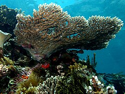
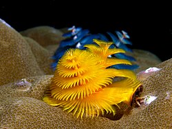
While it covers only 1.6% of the planet's oceanic area, the region has 76% of all known coral species in the world. As a habitat for 52% of Indo-Pacific reef fishes and 37% of the world's reef fishes, it contains the greatest diversity of coral reef fishes in the world [16] More than 3,000 species of bony fish are distributed over more than 90% of the Coral Triangle. Among the largest of these fish are the whale shark, the coelacanth and the chimaerans. [4]

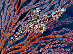
The Coral Triangle is the epicentre for the biodiversity, not only of corals and fish, but also of many other marine organisms. It contains roughly 950 species of Molluscs and 458 crustacean species. [4] It is also the habitat for six of the world's seven marine turtle species. [4]

Thirteen percent of the Coral Triangle has been identified as being clustered into hotspots of high marine biodiversity importance, including southern part of the Philippines, the north-eastern part of Sabah in Malaysia, central to eastern zones of Indonesia, the eastern part of Papua New Guinea and the Solomon Islands. [17] The parts of the Coral Triangle that have the highest number of species comprise 6% of the triangle's total area. They include stretches along the coast of the Philippines (including the northern coast of Luzon, Bohol, Mindanao, Palawan, and the Sulu Archipelago), [17] Malaysia (the northeastern coast of Sabah), Indonesia (the northern and southeastern part of Sulawesi, the Banda Sea, Maluku Islands (the Mollucas), and the Raja Ampat Archipelago of Indonesian Papua), [17] Papua New Guinea (the coastal areas of Madang Province, New Britain, Milne Bay, the Louisiade Archipelago, and Bougainville Island), [17] and the Solomon Islands (Guadalcanal and Makira-Ulawa Province). [17] [4] However, more than half (70%) of the zones in the Coral Triangle are classified as low species richness areas. [4]

The sites of highest marine biodiversity importance in the Coral Triangle include: (1) the northern tip of Sulawesi, (2) Ambon Island, (3) Kai Islands (also Kei Islands), (4) Raja Ampat Archipelago of Indonesian Papua, (5) the Verde Island Passage in the Philippines, (6) the southern part of Negros in the Philippines, and (7) Cebu in the Philippines. [17]

The greatest extent of mangrove forest in the world is also found in the Coral Triangle. These forests’ large area and extraordinary range of habitats and environmental conditions have played a major role in maintaining the staggering biodiversity of the Coral Triangle. [18]

The Coral Triangle countries comprised a minimum of 10 to a maximum of 19 seagrass species that belong to four distinct families (Hydrocharitaceae, Cymodoceaceae, Zosteraceae, and Ruppiaceae) and cover almost 58,550.63 km2. While a total of 21 species of seagrass have been found throughout this eco-region. [19]

A joint Indonesian–U.S. marine survey expedition in 2008 discovered deep-sea biodiversity and underwater active volcanoes at a depth of 3800 meters along the western ridge. Around 40 newly identified deep-sea coral species were found there. Most are whitish in color, because the area is not a habitat for colorful algae species, which are generally shallow-living. Hydrothermal vents and coral reefs at a depth of 4000 meters were found to have created a habitat for marine niche shrimps, crabs, barnacles, and sea cucumbers. [20]

According to Indonesia's Minister of Research and Technology / National Research and Innovation Agency (Menristek / Head of BRIN), Bambang Permadi Soemantri Brodjonegoro, Coral Triangle countries are in need of a greater number of taxonomists and oceanographers to address the challenges of cataloguing the biodiversity in the area. He has said that goal of this research is not only to increase human knowledge, but also to apply that knowledge to the project of protecting coastal and marine biodiversity from extinction. [21]

Theories behind high species diversity of the Coral Triangle

There are three different theories as to why the Coral Triangle (East Indies Triangle) has such a high diversity of species, and each theory proposes a different explanatory model. They are usually termed the “centre of origin” model, the “centre of overlap” model, and the “centre of accumulation” model. [22] [23]

Threats

The Coral Triangle lies at a crossroads of rapidly increasing anthropogenic activities, (population growth, economic growth and international trade), [24] habitat change, over-exploitation of resources, [19] and climate change. [4] Competition, predation, fishing practices, marine pollution, marine debris, dredging, sunscreen contamination, climate change, ocean acidification (OA), disease, recreational diving, sea level rise, temperature increase and other issues briefly described in environmental issues with coral reefs. [19]

Ocean acidification is a global threat to coral reef ecosystems. [25] Based on the biodiversity in the Coral Triangle area, damage will come to many sectors, because the coral reef is a fundamental ecosystem in the coastal area. Started by rising levels of atmospheric carbon dioxide, the calcium carbonate decrease then enhances bioerosion and dissolution rate. The CT should have oligotrophic waters, so the light would penetrate and support photosynthesis by zooxanthellae algae. However coral reef in West Maui, Hawaii, has a sustained condition of nutrient-rich, lower pH submarine groundwater discharge that lowers the pH of seawater. Also, the corals are exposed to nitrate concentrations 50 times higher than ambient.[ clarification needed ] Rates of coral calcification are substantially decreased, and rates of bioerosion are orders of magnitude higher than in healthy oligotrophic waters. Measurement using heavier nitrogen isotope (δ15N) values shows that eutrophication of reef seawater by land‐based sources of pollution can magnify the effects of ocean acidification through nutrient-driven-bioerosion. These conditions could contribute to the collapse of coastal coral reef ecosystems sooner than current projections based only on ocean acidification predict.

The biodiversity and natural productivity of the coral triangle are under threat from poor marine management (primarily from coastal development, overfishing and destructive fishing), lack of political will, poverty, high market demand, local disregard for rare and threatened species, climate change (warming, ocean acidification and rising sea levels). Coral reefs have experienced mass bleaching, which threaten to degrade the important ecosystems. An estimated 120 million people live within the Coral Triangle, of which approximately 2.25 million are fishers who depend on healthy seas to make a living. These threats are putting at risk livelihoods, economies, and future market supplies for species such as tuna. [26] Studies have highlighted the alarming decline of coral cover in this region. [27] However, a report published in 2021 described the reefs of the Coral Triangle as having shown resilience to large scale bleaching events. The Global Coral Reef Monitoring Network (GCRMN) reported in 2021, that the East Asian Seas region, which includes the Coral Triangle, was the only region where coral cover was substantially greater in 2019 (36.8%) as compared to 1983 (32.8%), which is the year that the earliest data was collected. This increase in coral cover occurred notwithstanding the reefs were affected by large scale coral bleaching events during the 2010s. The data on the cover of algae in the East Asian Seas shows that the cover of algae has progressively decreased resulting in an average of five times more coral than algae on these reefs. [28]

Since the marine resources are a principal source of income for the population, the downstream effects of losing these critical coastal ecosystems are enormous.

Conservation

The Coral Triangle is the subject of high-level conservation efforts by the region's governments, nature conservation organizations such as World Wide Fund for Nature, The Nature Conservancy and Conservation International, and donor agencies such as the Asian Development Bank, the Global Environment Facility and USAID.

Coral Triangle Initiative on Coral Reefs, Fisheries, and Food Security

In August 2007, Indonesia's President Yudhoyono proposed a multilateral partnership to "safeguard the region’s marine and coastal biological resources" with five other countries geographically located in the CT (Malaysia, Timor-Leste, Papua New Guinea, Solomon Islands, and the Philippines). [24] The multilateral partnership then named as Coral Triangle Initiative on Coral Reefs, Fisheries and Food Security (CTI-CFF).

Goals of CTI-CFF

The plan of action of the CTI-CFF, is to achieve the following: [29] [30]

  1. Priority seascapes designated and effectively managed
  2. Ecosystem Approach to Management of Fisheries (EAFM) and other marine resources fully applied
  3. Marine Protected Areas (MPAs) established and effectively managed
  4. Climate change adaptation measures achieved
  5. Threatened species status improving

The longer-term goals of the CTI-CFF are to: [31] [32]

  • Stabilize and/or maintain coral reef ecosystem integrity and services
  • Improve and sustain fish stocks
  • Improve the affordability, availability, quality, and safety of food coming from coastal and marine environments

Meeting

The solid-science resources management strength[ clarification needed ] builds with the scientific support of the university and research institute. On 28 February - 1 March 2017, the 1st Meeting of the CTI-CFF University Partnership in Manado [33] was held, aimed at: [34]

  1. agreeing on CTI-CFF University Partnerships conceptual framework and mechanism, and the election of CTI-University Partnership Coordinator;
  2. building-up tangible and collaborative programs and funding support (education, research, and outreach) among Universities and research institutes that can be developed for supporting regional capacity buildings, research needed, and outreach programs related to the CTI-CFF Regional Plan of Action (RPOA) goals as to achieved qualified CTI-CFF outcomes;
  3. identifying possible support and mechanism to strengthening capacity and quality of Regional Secretariat, Technical Working Groups and the National Coordination Committee to undertake their functions.

The results of this meeting:

  1. the conceptual framework and mechanism of CTI-CFF University Partnerships was established,
  2. three tangible program/actions, specifically (a). capacity building priority program which establishes international M.Sc. subject on Coral Triangle Ecosystem Governance and special assistance program for Timor-Leste in developing fisheries and marine sciences education; (b). nine research priority programs and nine identified topics; (c). outreach priority actions[ clarification needed ]
  3. University Partnership Coordinator of CT-CFF is Prof. Dr. Grevo Gerung from Sam Ratulangi University, Indonesia for 2017-2020 and the second Meeting of the CTI-CFF University Partnership will be held in 2018.[ needs update ]

[24]

Delineation

The primary criteria used to delineate the Coral Triangle were:

There is considerable overlap between the boundaries of the Coral Triangle that are based primarily on high coral biodiversity (more than 500 species), and the boundaries based on the area of greatest biodiversity for coral reef fishes. [36] [37]

Media

The 2013 documentary film Journey to the South Pacific tells the story of Coral Triangle conservation against the backdrop of island life. [38]

See also

Related Research Articles

<span class="mw-page-title-main">Lombok Strait</span> Strait in Indonesia

The Lombok Strait, is a strait of the Bali Sea connecting to the Indian Ocean, and is located between the islands of Bali and Lombok in Indonesia. The Gili Islands are on the Lombok side.

<span class="mw-page-title-main">Philippine Sea</span> Marginal sea east and north-east of the Philippines

The Philippine Sea is a marginal sea of the Western Pacific Ocean east of the Philippine Archipelago and the largest sea in the world, occupying an estimated surface area of 5 million square kilometers. The Philippine Sea Plate forms the floor of the sea. Its western border is the first island chain to the west, comprising the Ryukyu Islands in the northwest and Taiwan in the west. Its southwestern border comprises the Philippine islands of Luzon, Catanduanes, Samar, Leyte, and Mindanao. Its northern border comprises the Japanese islands of Honshu, Shikoku and Kyūshū. Its eastern border is the second island chain to the east, comprising the Bonin Islands and Iwo Jima in the northeast, the Mariana Islands in the due east, and Halmahera, Palau, Yap and Ulithi in the southeast. Its southern border is Indonesia's Morotai Island.

<span class="mw-page-title-main">Southeast Asian coral reefs</span> Marine ecosystem

Southeast Asian coral reefs have the highest levels of biodiversity for the world's marine ecosystems. They serve many functions, such as forming the livelihood for subsistence fishermen and even function as jewelry and construction materials. Corals inhabit coastal waters off of every continent except Antarctica, with an abundance of reefs residing along Southeast Asian coastline in several countries including Indonesia, the Philippines, and Thailand. Coral reefs are developed by the carbonate-based skeletons of a variety of animals and algae. Slowly and over time, the reefs build up to the surface in oceans. Coral reefs are found in shallow, warm salt water. The sunlight filters through clear water and allows microscopic organisms to live and reproduce. Coral reefs are actually composed of tiny, fragile animals known as coral polyps. Coral reefs are significantly important because of the biodiversity. Although the number of fish are decreasing, the remaining coral reefs contain more unique sea creatures. The variety of species living on a coral reef is greater than anywhere else in the world. An estimation of 70-90% of fish caught are dependent on coral reefs in Southeast Asia and reefs support over 25% of all known marine species. However, those sensitive coral reefs are facing detrimental effects on them due to variety of factors: overfishing, sedimentation and pollution, bleaching, and even tourist-related damage.

<span class="mw-page-title-main">Marine protected area</span> Protected areas of seas, oceans, estuaries or large lakes

Marine protected areas (MPA) are protected areas of the world's seas, oceans, estuaries or in the US, the Great Lakes. These marine areas can come in many forms ranging from wildlife refuges to research facilities. MPAs restrict human activity for a conservation purpose, typically to protect natural or cultural resources. Such marine resources are protected by local, state, territorial, native, regional, national, or international authorities and differ substantially among and between nations. This variation includes different limitations on development, fishing practices, fishing seasons and catch limits, moorings and bans on removing or disrupting marine life. In some situations, MPAs also provide revenue for countries, potentially equal to the income that they would have if they were to grant companies permissions to fish. The value of MPA to mobile species is unknown.

<span class="mw-page-title-main">Blast fishing</span> Using bombs underwater to kill fish

Blast fishing, fish bombing, dynamite fishing or grenade fishing is a destructive fishing practice using explosives to stun or kill schools of fish for easy collection. This often illegal practice is extremely destructive to the surrounding ecosystem, as the explosion often destroys the underlying habitat that supports the fish. The frequently improvised nature of the explosives used, and undetonated charges, means danger for fishermen and divers as well, with accidents and injuries.

<span class="mw-page-title-main">Ombai Strait</span> Strait in Southeast Asia

Ombai Strait is an international strait in Southeast Asia. It separates the Alor Archipelago from the islands of Wetar, Atauro, and Timor in the Lesser Sunda Islands. The strait is also the western portion of a pair of international straits, the other one being Wetar Strait; the two straits combine to link the Pacific Ocean with the Indian Ocean.

<span class="mw-page-title-main">Wetar Strait</span> Strait in Southeast Asia

Wetar Strait is an international strait in Southeast Asia. It separates the island of Wetar from the eastern part of the island of Timor. The strait is also the eastern portion of a pair of international straits, the other one being Ombai Strait; the two straits combine to link the Indian Ocean with the Pacific Ocean.

<span class="mw-page-title-main">Unsustainable fishing methods</span> Fishing methods with expected lowering of fish population

Unsustainable fishing methods refers to the utilization of the various fishing methods in order to capture or harvest fish at a rate which sees the declining of fish populations over time. These methods are observed to facilitate the destructive fishing practices that destroy ecosystems within the ocean, and more readily results in overfishing, the depletion of fish populations at a rate that cannot be sustained.

<span class="mw-page-title-main">Marine ecosystem</span> Ecosystem in saltwater environment

Marine ecosystems are the largest of Earth's aquatic ecosystems and exist in waters that have a high salt content. These systems contrast with freshwater ecosystems, which have a lower salt content. Marine waters cover more than 70% of the surface of the Earth and account for more than 97% of Earth's water supply and 90% of habitable space on Earth. Seawater has an average salinity of 35 parts per thousand of water. Actual salinity varies among different marine ecosystems. Marine ecosystems can be divided into many zones depending upon water depth and shoreline features. The oceanic zone is the vast open part of the ocean where animals such as whales, sharks, and tuna live. The benthic zone consists of substrates below water where many invertebrates live. The intertidal zone is the area between high and low tides. Other near-shore (neritic) zones can include mudflats, seagrass meadows, mangroves, rocky intertidal systems, salt marshes, coral reefs, lagoons. In the deep water, hydrothermal vents may occur where chemosynthetic sulfur bacteria form the base of the food web.

<span class="mw-page-title-main">Verde Island Passage</span> Strait

The Verde Island Passage is a strait that separates the islands of Luzon and Mindoro in the Philippines, connecting the South China Sea with the Tayabas Bay and the Sibuyan Sea beyond. Traditionally, the sea lane has been one of the busiest in the Philippines because it acts as a corridor from the Port of Manila to the Visayas and Mindanao in the south. A network of ferry routes cross the passage and connect the surrounding provinces of Batangas, Marinduque, Occidental Mindoro, Oriental Mindoro and Romblon. The Verde Island Passage is identified as a site of highest marine biodiversity importance in the Coral Triangle. The 1.14 million hectare passage is extremely rich in marine biodiversity and has been called "Center of the Center of Marine Shorefish Biodiversity" with various conservation groups and local government units pushing for its nomination as a UNESCO World Heritage Site.

<span class="mw-page-title-main">Raja Ampat Islands</span> Archipelago in Southwest Papua, Indonesia

Raja Ampat, or the Four Kings, is an archipelago located off of the northwest tip of Bird's Head Peninsula, Southwest Papua province, Indonesia. It comprises over 1,500 small islands, cays, and shoals around the four main islands of Misool, Salawati, Batanta, and Waigeo, and the smaller island of Kofiau.

<span class="mw-page-title-main">Wild fisheries</span> Area containing fish that are harvested commercially

A wild fishery is a natural body of water with a sizeable free-ranging fish or other aquatic animal population that can be harvested for its commercial value. Wild fisheries can be marine (saltwater) or lacustrine/riverine (freshwater), and rely heavily on the carrying capacity of the local aquatic ecosystem.

<span class="mw-page-title-main">Central Indo-Pacific</span> Biogeographic sea region

The Central Indo-Pacific is a biogeographic region of Earth's seas, comprising the tropical waters of the western Pacific Ocean, the eastern Indian Ocean, and the connecting seas.

Defying Ocean's End (DOE) is a global agenda for action in marine conservation compiled in a 2004 Island Press book. It is also the title of a 2003 Los Cabos (Mexico) conference, where the agenda was formulated.

<span class="mw-page-title-main">Environmental issues with coral reefs</span> Factors which adversely affect tropical coral reefs

Human activities have substantial impact on coral reefs, contributing to their worldwide decline.[1] Damaging activities encompass coral mining, pollution, overfishing, blast fishing, as well as the excavation of canals and access points to islands and bays. Additional threats comprise disease, destructive fishing practices, and the warming of oceans.[2] Furthermore, the ocean's function as a carbon dioxide sink, alterations in the atmosphere, ultraviolet light, ocean acidification, viral infections, the repercussions of dust storms transporting agents to distant reefs, pollutants, and algal blooms represent some of the factors exerting influence on coral reefs. Importantly, the jeopardy faced by coral reefs extends far beyond coastal regions. The ramifications of climate change, notably global warming, induce an elevation in ocean temperatures that triggers coral bleaching—a potentially lethal phenomenon for coral ecosystems.

<span class="mw-page-title-main">Living Oceans Society</span> Canadian environmental organization

Living Oceans Society is a Canadian environmental organization that has been a leader in the effort to protect Canada's oceans since 1998. It is based in Sointula, British Columbia, with a satellite office in Vancouver, British Columbia. Living Oceans Society's vision states that: "Canada's oceans are sustainably managed and thriving with abundant sea life that supports vibrant and resilient communities."

Blue Ventures is a registered charity focused on nurturing locally led marine conservation. The organisation partners with coastal communities that depend on marine resources.

<span class="mw-page-title-main">Pom Pom Island</span> Island in Malaysia

Pom Pom Island is a small coral reef island in the Celebes Sea approximately 30 kilometres north east of Semporna town, Sabah, East Malaysia.

The Coral Triangle Initiative on Coral Reefs, Fisheries, and Food Security (CTI-CFF), or the Coral Triangle Initiative (CTI), is a multilateral collaborative partnership among six countries. Partners work together to sustain living marine and coastal resources by addressing crucial issues such as food security, climate change, and marine biodiversity.

The Coral Triangle Day was established on June 9, to celebrate and raise awareness of the ocean conservation and protection, especially on the Coral Triangle, the world's epicenter of marine biodiversity. Intended as an open-sourced event, the day is celebrated by individuals, organizations, and establishment concerned on the Coral Triangle. The Coral Triangle day was observed the first time on June 9, 2012, in conjunction with the World Oceans Day on June 8.

References

  1. Weeks, Rebecca; Aliño, Porfirio M.; Atkinson, Scott; Beldia, Pacifico; Binson, Augustine; Campos, Wilfredo L.; Djohani, Rili; Green, Alison L.; Hamilton, Richard; Horigue, Vera; Jumin, Robecca; Kalim, Kay; Kasasiah, Ahsanal; Kereseka, Jimmy; Klein, Carissa; Laroya, Lynette; Magupin, Sikula; Masike, Barbara; Mohan, Candice; Da Silva Pinto, Rui Miguel; Vave-Karamui, Agnetha; Villanoy, Cesar; Welly, Marthen; White, Alan T. (4 March 2014). "Developing Marine Protected Area Networks in the Coral Triangle: Good Practices for Expanding the Coral Triangle Marine Protected Area System" (PDF). Coastal Management. 42 (2): 183–205. Bibcode:2014CoasM..42..183W. doi: 10.1080/08920753.2014.877768 .
  2. Gray, Alex (13 September 2018). "The 'Coral Triangle' is the largest of its kind, and it's dying". Global Agenda. World Economic Forum. Retrieved 20 November 2020.
  3. Veron et al. Unpublished data
  4. 1 2 3 4 5 6 7 8 9 Asaad, Irawan; Lundquist, Carolyn J.; Erdmann, Mark V.; Hooidonk, Ruben Van; Costello, Mark J. (5 November 2018). "Designating Spatial Priorities for Marine Biodiversity Conservation in the Coral Triangle". Front. Mar. Sci. 5: 400. doi: 10.3389/fmars.2018.00400 . S2CID   53294894.
  5. Veron, J.E.N. 1995. Corals in space and time: biogeography and evolution of the Scleractinia. UNSW Press, Sydney, Australia: xiii + 321 pp.
  6. Speers, A. E., Besedin, E. Y., Palardy, J. E., & Moore, C. (2016). Impacts of climate change and ocean acidification on coral reef fisheries: an integrated ecological–economic model. Ecological economics, 128, 33-43. Retrieved 26 September 2020
  7. Allen, G. R. 2007 Conservation hotspots of biodiversity and endemism for Indo-Pacific coral reef fishes. Aquatic Conserv: Mar. Freshw. Ecosyst. doi : 10.1002/aqc.880
  8. Briggs, J. C. 2005a. The marine East Indies: diversity and speciation. Journal of Biogeography 32: 1517-1522
  9. "ADB to help improve resources management in coral triangle". Archived from the original on 2018-03-17. Retrieved 2011-05-23.
  10. "Coral reef destruction spells humanitarian disaster". 17 May 2011.
  11. Coral Triangle Knowledge Network
  12. WWF Coral Triangle Program
  13. "Verde Island Passage".
  14. ""World Heritage Coral Reefs" Exhibit opens in Paris".
  15. ""Raja Ampat UNESCO Global Geopark".
  16. Hoegh-Guldberg, O (2009). The Coral Triangle and Climate Change: Ecosystems, People, and Societies at Risk (PDF). Sydney: WWF Australia. ISBN   978-1-921031-35-9. Archived from the original (PDF) on 2017-01-17. Retrieved 2016-03-30.
  17. 1 2 3 4 5 6 Asaad, Irawan; Lundquist, Carolyn J.; Erdmann, Mark V.; Costello, Mark J. (June 2018). "Delineating priority areas for marine biodiversity conservation in the Coral Triangle". Biological Conservation. 222 (2): 198–211.
  18. The Nature Conservancy. Coral Triangle Facts, Figures, and Calculations: Part II: Patterns of Biodiversity and Endemism, December 16, 2008
  19. 1 2 3 Al-Asif, Abdulla-; Abu Hena, Mustafa Kamal; Hamli, Hadi; Idris, Mohd Hanafi; Gerusu, Geoffery James; Ismail, Johan; Bhuiyan, Md Khurshid Alam; Abualreesh, Muyassar H.; Musa, Najiah; Wahid, Mohd Effendy Abd; Mishra, Manoranjan (20 May 2022). "Status, Biodiversity, and Ecosystem Services of Seagrass Habitats Within the Coral Triangle in the Western Pacific Ocean". Ocean Science Journal. 57 (2): 147–173. Bibcode:2022OSJ....57..147A. doi: 10.1007/s12601-022-00068-w .
  20. Normile, D. (2010). Joint Expedition Discovers Deep-Sea Biodiversity, New Volcanoes.
  21. "Indonesia Kekurangan Ahli Taksonomi Kelautan". darilaut.id. 19 September 2020. Retrieved 29 September 2020.
  22. Briggs, J. C. (21 September 2009). "Diversity, endemism and evolution in the Coral Triangle". Journal of Biogeography. 36 (10): 2008–2010. Bibcode:2009JBiog..36.2008B. doi:10.1111/j.1365-2699.2009.02146.x. S2CID   85033550.
  23. Hernawan, Udhi Eko. "Marine biodiversity in Indonesia". YouTube . Archived from the original on 2021-12-15. Retrieved 29 September 2020.
  24. 1 2 3 "CTI Regional Plan of Action | CTI-CFF". www.coraltriangleinitiative.org. Retrieved 2016-03-30.
  25. Prouty, N. G.; Cohen, A.; Yates, K. K.; Storlazzi, C. D.; Swarzenski, P. W.; White, D. (2017). "Vulnerability of coral reefs to bioerosion from land-based sources of pollution". Journal of Geophysical Research: Oceans. 122 (12): 9319–9331. Bibcode:2017JGRC..122.9319P. doi: 10.1002/2017JC013264 . hdl: 1912/9534 .
  26. http://www.panda.org/what_we_do/where_we_work/coraltriangle/problems/ WWF - Problems in the Coral Triangle
  27. Peñaflor et al. 2009. Sea-surface temperature and thermal stress in the Coral Triangle over the past two decades. Coral Reefs 28:4. pp 841-850
  28. Edited by: David Souter, Serge Planes, Jérémy Wicquart, Murray Logan, David Obura and Francis Staub (2021). Status of Coral Reefs of the World: 2020 Executive Summary (PDF) (Report). Global Coral Reef Monitoring Network (GCRMN). p. 19.{{cite report}}: |author1= has generic name (help)CS1 maint: multiple names: authors list (link)
  29. Regional State of the Coral Triangle - Coral Triangle Marine Resources: Their Status, Economies, and Management (Report). Asian Development Bank. 2014. p. 33.
  30. "CTI Regional Plan of Action". www.coraltriangleinitiative.org. Retrieved 2016-03-29.
  31. Regional State of the Coral Triangle - Coral Triangle Marine Resources: Their Status, Economies, and Management (Report). Asian Development Bank. 2014. pp. 42–48.
  32. "CTI Regional Plan of Action". www.coraltriangleinitiative.org. Retrieved 8 April 2024.
  33. "The First CTI-CFF University Partnership Meeting". 23 February 2017.
  34. "Report of the 1st Meeting of CTI-CFF University Partnership. Manado, Indonesia, 28 February – 1 March 2017" (PDF). Coral Triangle Initiative for Coral Reefs, Fisheries, and Food. Security (CTI-CFF). Retrieved 28 September 2020.
  35. 1 2 Castruccio, F. S.; Curchitser, E. N.; Kleypas, J. A. (19 November 2013). "A model for quantifying oceanic transport and mesoscale variability in the Coral Triangle of the Indonesian/Philippines Archipelago". Journal of Geophysical Research: Oceans. 118 (11): 6123–6144. Bibcode:2013JGRC..118.6123C. doi:10.1002/2013JC009196.
  36. The Nature Conservancy. 2004. Delineating the Coral Triangle, its ecoregions, and functional seascapes. Report on an expert workshop, held at the Southeast Asia Center for Marine Protected Areas, Bali, Indonesia, (April 30 - May 2, 2003), Version 1.1 (June 2004)
  37. Hoeksema BW. 2007.Delineation of the Indo-Malayan Centre of Maximum Marine Biodiversity: The Coral Triangle. In: W. Renema (ed.) Biogeography, Time and Place: Distributions, Barriers, and Islands, pp 117-178. Springer, Dordrecht.
  38. Chang, Justin (December 13, 2013). "Film Review: 'Journey to the South Pacific'". Variety. Retrieved 10 February 2014.