New Caledonian barrier reef

Last updated

Lagoons of New Caledonia: Reef Diversity and Associated Ecosystems
UNESCO World Heritage Site
Lagoons and Reefs of New Caledonia May 10, 2001.jpg
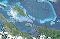
Northern tip of Grande Terre
Location New Caledonia (state party: France)
Includes
  1. Grand Lagon Sud
  2. Zone Côtière Ouest
  3. Zone Côtière Nord-Est
  4. Grand Lagon Nord
  5. Atolls d’Entrecasteaux  [ fr ]
  6. Atoll d’Ouvéa et Beautemps-Beaupré  [ fr ]
Criteria Natural: (vii), (ix), (x)
Reference 1115
Inscription2008 (32nd Session)
Area1,574,300 ha (3,890,000 acres)
Buffer zone1,287,100 ha (3,180,000 acres)
Coordinates 20°24′43″S164°33′59″E / 20.41194°S 164.56639°E / -20.41194; 164.56639
Nouvelle-Caledonie collectivity relief location map centered.jpg
Red pog.svg
Location of New Caledonian barrier reef in New Caledonia
Oceania laea relief location map.jpg
Red pog.svg
New Caledonian barrier reef (Oceania)

The New Caledonian barrier reef is a barrier reef located in New Caledonia in the South Pacific, being the longest continuous barrier reef in the world and the third largest after the Great Barrier Reef of Australia and the Mesoamerican Barrier Reef.

Contents

The New Caledonian barrier reef surrounds Grande Terre, New Caledonia's largest island, as well as the Ile des Pins and several smaller islands, reaching a length of 1,500 kilometres (930 mi). The reef encloses a lagoon of 24,000 square kilometres (9,300 sq mi), which has an average depth of 25 metres (82 ft). The reefs lie up to 30 kilometres (19 mi) from the shore, but extend almost 200 kilometres (120 mi) to the Entrecasteaux reefs in the northwest. This northwestern extension encloses the Belep Islands and other sand cays. Several natural passages open out to the ocean. The Boulari passage, which leads to Nouméa, the capital and chief port of New Caledonia, is marked by the Amédée lighthouse.

In 2008, the barrier reef and its enclosing lagoon was inscribed on the UNESCO World Heritage List for its outstanding beauty, its unique geography as a reef entirely encircling Grande Terre, and its exceptional marine diversity (in particular its coral diversity). [1]

Ecology

The reef systems of New Caledonia are considered to be the second largest in the world after the Great Barrier Reef of Australia, the longest continuous barrier reef in the world with a length of 1,600 km and its lagoon, the largest in the world with an area of 24,000 square kilometers. This ecosystem hosts along with Fiji, the world's most diverse concentration of reef structures, 146 types based on a global classification system, and they equal or even surpass the much larger Great Barrier Reef in coral and fish diversity. [1]

The reef has great species diversity with a high level of endemism. In total, there have been 2328 fish species observed in the reef, belonging to 248 families. [2] In addition, the reef is home to third-largest population of endangered dugongs (Dugong dugon) on Earth, and is an important nesting site for green sea turtles (Chelonia mydas). [1]

In the lagoons of New Caledonia there are many other marine species, including over 2000 species of molluscs [3] and a thriving population of humpback whales. [4]

Environmental threats

Most of the reefs are generally thought to be in good health. Some of the eastern reefs have been damaged by effluent from nickel mining on Grand Terre. Sedimentation from mining, agriculture, and grazing has affected reefs near river mouths, which has been worsened by the destruction of mangrove forests, which help to retain sediment. Some reefs have been buried under several metres of silt. [5] In 2008, an assessment of northwest near-shore reefs concluded that many would be dead within years, and at best decades, if present trends relating to mining sediment and silt run-off continued. [6]

In January 2002, the French government proposed listing New Caledonia's reefs as a UNESCO World Heritage Site. UNESCO listed New Caledonia barrier reef on the World Heritage List under the name The Lagoons of New Caledonia: Reef Diversity and Associated Ecosystems on 7 July 2008. [1]

There are 13 local management committees, composed of tourist operators, fishermen, politicians and chiefs of local tribes which work with the community to monitor the health of the lagoons. [7]

Human use

Scuba Diving is common, with several dive sites in the lagoon and around the reef. These include the Prony needle, the Shark Pit and the Cathedral. [8]

See also

Related Research Articles

<span class="mw-page-title-main">New Caledonia</span> French special collectivity in the southwest Pacific Ocean

New Caledonia is a sui generis collectivity of overseas France in the southwest Pacific Ocean, south of Vanuatu, about 1,210 km (750 mi) east of Australia, and 17,000 km (11,000 mi) from Metropolitan France. The archipelago, part of the Melanesia subregion, includes the main island of Grande Terre, the Loyalty Islands, the Chesterfield Islands, the Belep archipelago, the Isle of Pines, and a few remote islets. The Chesterfield Islands are in the Coral Sea. French people, especially locals, call Grande Terre "Le Caillou".

<span class="mw-page-title-main">Geography of New Caledonia</span>

The geography of New Caledonia (Nouvelle-Calédonie), an overseas collectivity of France located in the subregion of Melanesia, makes the continental island group unique in the southwest Pacific. Among other things, the island chain has played a role in preserving unique biological lineages from the Mesozoic. It served as a waystation in the expansion of the predecessors of the Polynesians, the Lapita culture. Under the Free French it was a vital naval base for Allied Forces during the War in the Pacific.

<span class="mw-page-title-main">Great Barrier Reef</span> Coral reef system located in the Coral Sea in Australia

The Great Barrier Reef is the world's largest coral reef system, composed of over 2,900 individual reefs and 900 islands stretching for over 2,300 kilometres (1,400 mi) over an area of approximately 344,400 square kilometres (133,000 sq mi). The reef is located in the Coral Sea, off the coast of Queensland, Australia, separated from the coast by a channel 160 kilometres (100 mi) wide in places and over 61 metres (200 ft) deep. The Great Barrier Reef can be seen from outer space and is the world's biggest single structure made by living organisms. This reef structure is composed of and built by billions of tiny organisms, known as coral polyps. It supports a wide diversity of life and was selected as a World Heritage Site in 1981. CNN labelled it one of the Seven Natural Wonders of the World in 1997. Australian World Heritage places included it in its list in 2007. The Queensland National Trust named it a state icon of Queensland in 2006.

<span class="mw-page-title-main">Great Barrier Reef Marine Park</span> Protected area in Queensland, Australia

The Great Barrier Reef Marine Park protects a large part of Australia's Great Barrier Reef from damaging activities. It is a vast multiple-use Marine Park which supports a wide range of uses, including commercial marine tourism, fishing, ports and shipping, recreation, scientific research and Indigenous traditional use. Fishing and the removal of artefacts or wildlife is strictly regulated, and commercial shipping traffic must stick to certain specific defined shipping routes that avoid the most sensitive areas of the park. The Great Barrier Reef is the largest and best known coral reef ecosystem in the world. Its reefs, almost 3000 in total, represent about 10 per cent of all the coral reef areas in the world. It supports an amazing variety of biodiversity, providing a home to thousands of coral and other invertebrate species, bony fish, sharks, rays, marine mammals, marine turtles, sea snakes, as well as algae and other marine plants.

<span class="mw-page-title-main">Coral reef</span> Outcrop of rock in the sea formed by the growth and deposit of stony coral skeletons

A coral reef is an underwater ecosystem characterized by reef-building corals. Reefs are formed of colonies of coral polyps held together by calcium carbonate. Most coral reefs are built from stony corals, whose polyps cluster in groups.

<span class="mw-page-title-main">Aldabra</span> Coral atoll in the Indian Ocean

Aldabra is the world's second-largest coral atoll, lying southeast of the continent of Africa. It is part of the Aldabra Group of islands in the Indian Ocean that are part of the Outer Islands of the Seychelles, with a distance of 1,120 km (700 mi) southwest of the capital, Victoria on Mahé Island.

<span class="mw-page-title-main">Coral Sea</span> Marginal sea of the South Pacific off the northeast coast of Australia

The Coral Sea is a marginal sea of the South Pacific off the northeast coast of Australia, and classified as an interim Australian bioregion. The Coral Sea extends 2,000 kilometres (1,200 mi) down the Australian northeast coast. Most of it is protected by the French Natural Park of the Coral Sea and the Australian Coral Sea Marine Park. The sea was the location for the Battle of the Coral Sea, a major confrontation during World War II between the navies of the Empire of Japan, and the United States and Australia.

<span class="mw-page-title-main">Biodiversity of New Caledonia</span> Variety of life in the New Caledonia archipelago and its seas

The biodiversity of New Caledonia is of exceptional biological and paleoecological interest. It is frequently referred to as a biodiversity hotspot. The country is a large South Pacific archipelago with a total land area of more than 18,000 square kilometres (6,900 sq mi). The terrain includes a variety of reefs, atolls, small islands, and a variety of topographical and edaphic regions on the largest island, all of which promote the development of unusually concentrated biodiversity. The region's climate is oceanic and tropical.

<span class="mw-page-title-main">Belize Barrier Reef</span> Series of coral reefs straddling the coast of Belize

The Belize Barrier Reef is a series of coral reefs straddling the coast of Belize, roughly 300 metres (980 ft) offshore in the north and 40 kilometres (25 mi) in the south within the country limits. The Belize Barrier Reef is a 300-kilometre (190 mi) long section of the 900-kilometre (560 mi) Mesoamerican Barrier Reef System, which is continuous from Cancún on the north-eastern tip of the Yucatán Peninsula through the Riviera Maya and down to Honduras, making it the second largest coral reef system in the world after the Great Barrier Reef in Australia. It is Belize's top tourist destination, popular for scuba diving and snorkeling and attracting almost half of its 260,000 visitors. It is also vital to the country's fishing industry.

<span class="mw-page-title-main">Environmental threats to the Great Barrier Reef</span>

The Great Barrier Reef is the world's largest reef systems, stretching along the East coast of Australia from the northern tip down at Cape York to the town of Bundaberg, is composed of roughly 2,900 individual reefs and 940 islands and cays that stretch for 2,300 kilometres (1,616 mi) and cover an area of approximately 344,400 square kilometres (133,000 sq mi). The reef is located in the Coral Sea, off the coast of Queensland in northeast Australia. A large part of the reef is protected by the Great Barrier Reef Marine Park.

<span class="mw-page-title-main">Apo Reef</span> Coral reef in the Philippines

Apo Reef is a coral reef system in the Philippines situated in the western waters of Occidental Mindoro province in the Mindoro Strait. Encompassing 34 square kilometres (13 sq mi), it is considered the world's second-largest contiguous coral reef system, and is the largest in the country. The reef and its surrounding waters are protected areas administered as the Apo Reef Natural Park (ARNP). It is one of the best known and most popular diving regions in the country, and is in the tentative list for UNESCO World Heritage Sites.

Bacalar Chico National Park and Marine Reserve (BCNPMR) is a protected area and UNESCO World Heritage Site on the northern part of Ambergris Caye in Belize.

The Arrecifes de Cozumel National Park is off the coast of the island of Cozumel in the state of Quintana Roo, Mexico. The Cozumel reef system is part of the Mesoamerican Barrier Reef System, the second largest coral reef system in the world. Even though almost the entire island of Cozumel is surrounded by coral reefs, the park only encompasses the reefs on the south side of the island. It begins just south of the International Pier and continues down and around Punta Sur and up just a small portion of the east side of the island. The park contains both shallow and mesophotic coral reefs and extends to the 100 m depth isobar.

<span class="mw-page-title-main">Grande Terre (New Caledonia)</span> Pacific island territory of France

Grande Terre is the largest and principal island of New Caledonia, which is a territory of France.

<span class="mw-page-title-main">Mohéli National Park</span>

Mohéli National Park is a national park in the Comoros. It includes marine, coastal, and terrestrial areas on and around the island of Mohéli. The park has an area of 643.62 km2. Established as Mohéli Marine Park on 19 April 2001, it was first protected area in the Comoros. It was redesignated a national park in 2010. In 2015 the park was expanded to include about three-quarters of Mohéli's terrestrial area. It is the southernmost territory of the southernmost Arabic-speaking country.

<span class="mw-page-title-main">Lighthouse Reef</span> Atoll off the coast of Belize

Lighthouse Reef is an atoll in the Caribbean Sea, the easternmost part of the Belize Barrier Reef and one of its three atolls, the other two being Turneffe Atoll and Glover's Reef. Lighthouse Reef is located about 80 kilometres (50 mi) southeast of Belize City. The atoll is of oblong shape, approximately 35 kilometres (22 mi) long from north to south, and about 8 kilometres (5.0 mi) wide. It forms a shallow sandy lagoon with an area of 120 square kilometres (46 sq mi) and a depth between 2 and 6 metres deep.

<span class="mw-page-title-main">Natural Park of the Coral Sea</span>

The Natural Park of the Coral Sea, founded in 2014, is a marine park located in New Caledonia, a special collectivity of France. As of 2017 it is the fourth largest protected area in the world, encompassing 1,292,967 square kilometres. It includes the UNESCO World Heritage Site The Lagoons of New Caledonia: Reef Diversity and Associated Ecosystems. The possibility granted to the government of New Caledonia to allow cruise ships to circulate there in the future has generated controversy.

<span class="mw-page-title-main">Mayotte Marine Natural Park</span> Marine Park in the Comoro Islands

The Mayotte Marine Natural Park is a marine park surrounding Mayotte, a French overseas region. Mayotte is part of the Comoro Islands archipelago, which lies within the Mozambique Channel in the western Indian Ocean. Established in 2010, the park covers the entirety of Mayotte's territorial waters and exclusive economic zone. It is contiguous with the Glorioso Islands Marine Natural Park, which was established two years later.

<span class="mw-page-title-main">Coral reefs of Kiribati</span> Pacific Ocean Island chain

The Coral reefs of Kiribati consists of 32 atolls and one raised coral island, Banaba, which is an isolated island between Nauru and the Gilbert Islands. The islands of Kiribati are dispersed over 3.5 million km2 (1.4 million sq mi) of the Pacific Ocean and straddle the equator and the 180th meridian, extending into the eastern and western hemispheres, as well as the northern and southern hemispheres. 21 of the 33 islands are inhabited. The groups of islands of Kiribati are:

<span class="mw-page-title-main">Coral reefs of the Solomon Islands</span>

The Coral reefs of the Solomon Islands consists of six major islands and over 986 smaller islands, in Oceania, to the east of Papua New Guinea and northwest of Vanuatu. The Solomon Islands lie between latitudes 5° and 13°S, and longitudes 155° and 169°E. The distance between the westernmost and easternmost islands is about 1,500 km (930 mi). The Santa Cruz Islands are situated north of Vanuatu and are especially isolated at more than 200 km (120 mi) from the other islands. The Solomon Islands has the 22nd largest Exclusive Economic Zone of 1,589,477 km2 (613,701 sq mi) of the Pacific Ocean.

References

  1. 1 2 3 4 "Lagoons of New Caledonia: Reef Diversity and Associated Ecosystems". UNESCO World Heritage Centre. Archived from the original on 27 December 2016. Retrieved 18 December 2016.
  2. Mallet, Delphine; Vigliola, Laurent; Wantiez, Laurent; Pelletier, Dominique (2016). "Diurnal temporal patterns of the diversity and the abundance of reef fishes in a branching coral patch in New Caledonia" (PDF). Austral Ecology. 41 (7): 733–744. doi:10.1111/aec.12360.
  3. Bouchet, Philippe; Lozouet, Pierre; Maestrati, Philippe; Heros, Virginie (20 April 2002). "Assessing the magnitude of species richness in tropical marine environments: exceptionally high numbers of molluscs at a New Caledonia site". Biological Journal of the Linnean Society. 75 (4): 421–436. doi: 10.1046/j.1095-8312.2002.00052.x .
  4. Garrigue, Claire; Zerbini, Alexandre N.; Geyer, Ygor; Heide-Jorgensen, Mads-Peter; Hanaoka, Wakao; Clapham, Phil (17 February 2010). "Movements of satellite-monitored humpback whales from New Caledonia". Journal of Mammalogy. 91 (1): 109-115. doi: 10.1644/09-MAMM-A-033R.1 .
  5. "New Caledonia Barrier Reef". WWF. Archived from the original on 20 December 2016. Retrieved 18 December 2016.
  6. Fenner, Douglas; Muir, Paul (1 February 2008). "Reef Corals of the Northwestern Lagoon of Grande-Terre, New Caledonia". A Rapid Marine Biodiversity Assessment of the Coral Reefs of the Northwest Lagoon, between Koumac and Yandé, Province Nord, New Caledonia. p. 18. doi:10.1896/054.053.0102.
  7. "Historic Local community meeting in New Caledonia to strengthen World Heritage conservation". UNESCO. 20 July 2015. Archived from the original on 20 December 2016. Retrieved 18 December 2016.
  8. "Scuba Diving". nouvelle caledonie. Archived from the original on 20 December 2016. Retrieved 18 December 2016.