Underwater photography is the process of taking photographs while under water. It is usually done while scuba diving, but can be done while diving on surface supply, snorkeling, swimming, from a submersible or remotely operated underwater vehicle, or from automated cameras lowered from the surface.

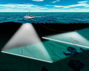
Bathymetry is the study of underwater depth of ocean floors, lake floors, or river floors. In other words, bathymetry is the underwater equivalent to hypsometry or topography. The first recorded evidence of water depth measurements are from Ancient Egypt over 3000 years ago. Bathymetric charts, are typically produced to support safety of surface or sub-surface navigation, and usually show seafloor relief or terrain as contour lines and selected depths (soundings), and typically also provide surface navigational information. Bathymetric maps may also use a Digital Terrain Model and artificial illumination techniques to illustrate the depths being portrayed. The global bathymetry is sometimes combined with topography data to yield a global relief model. Paleobathymetry is the study of past underwater depths.

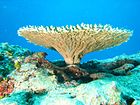
The Flower Garden Banks National Marine Sanctuary (FGBNMS) is a United States National Marine Sanctuary located 100 nautical miles (190 km) offshore of Galveston, Texas, in the northwestern Gulf of Mexico. It contains the northernmost coral reefs in the United States.
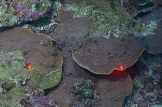
Pulley Ridge is a mesophotic coral reef system off the shores of the continental United States. The reef rests on sunken barrier islands and lies 100 miles west of the Tortugas Ecological Reserve and stretches north about 60 miles at depths ranging from 60 to 80 meters. Pulley Ridge was originally discovered in 1950 during a dredging operation conducted by an academic group from Texas. While well known to fishermen, this remarkable habitat remained undiscovered by scientists until 1999 when the U.S. Geological Survey (USGS) and graduate students from the University of South Florida happened upon it. This reef system, like other mesophotic ecosystems, is inhabited by photosynthesizing corals and algae that are adapted to low-light environments. It is habitat for numerous species of bottom fish including Epinephelus morio spawning area.

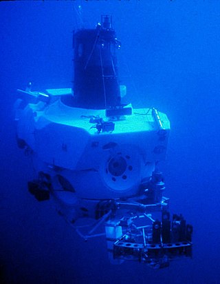
Unmanned underwater vehicles (UUV), also known as uncrewed underwater vehicles and underwater drones, are submersible vehicles that can operate underwater without a human occupant. These vehicles may be divided into two categories: remotely operated underwater vehicles (ROUVs) and autonomous underwater vehicles (AUVs). ROUVs are remotely controlled by a human operator. AUVs are automated and operate independently of direct human input.
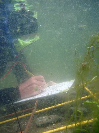
Scientific diving is the use of underwater diving techniques by scientists to perform work underwater in the direct pursuit of scientific knowledge. The legal definition of scientific diving varies by jurisdiction. Scientific divers are normally qualified scientists first and divers second, who use diving equipment and techniques as their way to get to the location of their fieldwork. The direct observation and manipulation of marine habitats afforded to scuba-equipped scientists have transformed the marine sciences generally, and marine biology and marine chemistry in particular. Underwater archeology and geology are other examples of sciences pursued underwater. Some scientific diving is carried out by universities in support of undergraduate or postgraduate research programs, and government bodies such as the United States Environmental Protection Agency and the UK Environment Agency carry out scientific diving to recover samples of water, marine organisms and sea, lake or riverbed material to examine for signs of pollution.

Reef Check is an international non-governmental organization dedicated to the conservation of two reef ecosystems: tropical coral reefs and Californian rocky reefs. The Foundation is headquartered in Los Angeles, California, United States, but uses data from volunteer scuba diver teams in over 80 countries, ranging from Australia, Japan, to even Germany. It is the United Nations’ official coral reef monitoring program.
Catlin Group Limited was a Bermuda-based specialty insurance and reinsurance company. Catlin operated six underwriting hubs worldwide and operated more than 55 offices worldwide. It owned the largest syndicate at Lloyd's of London, based on 2011 gross written premiums. Catlin shares were listed on the London Stock Exchange until it was acquired by XL Group plc in May 2015.
SJT-class ROUVs are a series of Chinese remotely operated underwater vehicles (ROUVs) jointly developed by the Shenyang Institute of Automation of the Chinese Academy of Science and the Institute of Underwater Engineering of Shanghai Jiao Tong University (SHJTU). The general designer of the SJT-class of ROUVs is Zhu Jimao (朱继懋), a professor at SHJTU, who also was the general designer of the earlier Type 7103 DSRV. Many more ROUVs have been developed after the SJT series, based on experience gained from this series.

Hotspot Ecosystem Research and Man's Impact On European Seas (HERMIONE) is an international multidisciplinary project, started in April 2009, that studies deep-sea ecosystems. HERMIONE scientists study the distribution of hotspot ecosystems, how they function and how they interconnect, partially in the context of how these ecosystems are being affected by climate change and impacted by humans through overfishing, resource extraction, seabed installations and pollution. Major aims of the project are to understand how humans are affecting the deep-sea environment and to provide policy makers with accurate scientific information, enabling effective management strategies to protect deep sea ecosystems. The HERMIONE project is funded by the European Commission's Seventh Framework Programme, and is the successor to the HERMES project, which concluded in March 2009.
Dive Xtras is a manufacturer of diver propulsion vehicles (DPVs) or dive scooters in Mukilteo, Washington, United States.

The Seaview SVII is an underwater camera designed by the Catlin Seaview Survey team, intended to photograph coral reefs to provide visual documentation of a reef's health. The camera is designed to be controlled by a diver in shallow waters, and is propelled at a constant slow speed by a propeller mounted near the rear of the camera. Only two SVIIs are currently in existence. The cameras were used by the Catlin Seaview Survey and Google to create Google Ocean, a means of displaying underwater images using Google's existing Street View platform.

Baited remote underwater video (BRUV) is a system used in marine biology research. By attracting fish into the field of view of a remotely controlled camera, the technique records fish diversity, abundance and behaviour of species. Sites are sampled by video recording the region surrounding a baited canister which is lowered to the bottom from a surface vessel or less commonly by a submersible or remotely operated underwater vehicle. The video can be transmitted directly to the surface by cable, or recorded for later analysis.
St. Crispin's Reef is an elongate outer-shelf coral reef in the Great Barrier Reef, Queensland, Australia.

Reef Life Survey is a marine life monitoring programme based in Hobart, Tasmania. It is international in scope, but predominantly Australian, as a large proportion of the volunteers are Australian. Most of the surveys are done by volunteer recreational divers, collecting biodiversity data for marine conservation. The database is available to marine ecology researchers, and is used by several marine protected area managements in Australia, New Zealand, American Samoa and the eastern Pacific.

A towboard is a piece of aquatic survey equipment consisting of a board attached to a rope that is towed by a surface vessel. It is used to tow one or more divers underwater at a constant depth to survey bottom features such as coral reefs. The diver may use a scuba set, or if only a snorkel, may remain at the surface, or travel underwater for around two minutes.
The Ocean Agency is an international nonprofit organization dedicated to marine conservation. Currently, The Ocean Agency is focused on coral reef conservation.
Cooper Reef, also called the Esperance Nearshore Artificial Reef, is a purpose-built artificial reef in Esperance, Western Australia. Completed in 2019, the reef was designed in collaboration with Recfishwest and artificial reef specialists at Subcon, and built with the help of local volunteers. It was constructed to attract fish and enhance fish stocks, thereby creating new fishing and recreation opportunities for tourists, anglers and local families. Graham Cooper, who is the South East Coast Recreational Fishing Council president, Esperance Deep Sea Angling Club member, and local fishing safety educator, was the driving force behind the reef and the reason it got its name.
An underwater survey is a survey performed in an underwater environment or conducted remotely on an underwater object or region. Survey can have several meanings. The word originates in Medieval Latin with meanings of looking over and detailed study of a subject. One meaning is the accurate measurement of a geographical region, usually with the intention of plotting the positions of features as a scale map of the region. This meaning is often used in scientific contexts, and also in civil engineering and mineral extraction. Another meaning, often used in a civil, structural, or marine engineering context, is the inspection of a structure or vessel to compare actual condition with the specified nominal condition, usually with the purpose of reporting on the actual condition and compliance with, or deviations from, the nominal condition, for quality control, damage assessment, valuation, insurance, maintenance, and similar purposes. In other contexts it can mean inspection of a region to establish presence and distribution of specified content, such as living organisms, either to establish a baseline, or to compare with a baseline.
Underwater exploration is the exploration of any underwater environment, either by direct observation by the explorer, or by remote observation and measurement under the direction of the investigators. Systematic, targeted exploration is the most effective method to increase understanding of the ocean and other underwater regions, so they can be effectively managed, conserved, regulated, and their resources discovered, accessed, and used. Less than 10% of the ocean has been mapped in any detail, less has been visually observed, and the total diversity of life and distribution of populations is similarly obscure.