Cozumel is an island and municipality in the Caribbean Sea off the eastern coast of Mexico's Yucatán Peninsula, opposite Playa del Carmen. It is separated from the mainland by the Cozumel Channel and is close to the Yucatán Channel. The municipality is part of the state of Quintana Roo, Mexico.

Puerto Galera, officially the Municipality of Puerto Galera, is a 1st class municipality in the province of Oriental Mindoro, Philippines. According to the 2020 census, it has a population of 41,961 people.

The Maldives are formed by 20 natural atolls, along with a few islands and isolated reefs today which form a pattern stretching from 7 degrees 10′ North to 0 degrees 45′ South. The largest of these atolls is Boduthiladhunmathi, while the atoll containing the most islands is Huvadhu.

The Chagos Archipelago or Chagos Islands is a group of seven atolls comprising more than 60 islands in the Indian Ocean about 500 kilometres (310 mi) south of the Maldives archipelago. This chain of islands is the southernmost archipelago of the Chagos–Laccadive Ridge, a long submarine mountain range in the Indian Ocean. In its north are the Salomon Islands, Nelsons Island and Peros Banhos; towards its south-west are the Three Brothers, Eagle Islands, Egmont Islands and Danger Island; southeast of these is Diego Garcia, by far the largest island. All are low-lying atolls, save for a few extremely small instances, set around lagoons.

The Laccadive Sea, also known as the Lakshadweep Sea, is a body of water bordering India, the Maldives, and Sri Lanka. It is located to the southwest of Karnataka, to the west of Kerala and to the south of Tamil Nadu. This warm sea has a stable water temperature through the year and is rich in marine life, the Gulf of Mannar alone hosting about 3,600 species. Mangaluru, Kasaragod, Kannur, Kozhikode, Ponnani, Kochi, Alappuzha, Kollam, Thiruvananthapuram, Tuticorin, Colombo, and Malé are the major cities on the shore of the Laccadive Sea. Kanyakumari, the southernmost tip of peninsular India, also borders this sea.

Baa Atoll is an administrative division of the Maldives. It consists of three separate natural atolls, namely southern Maalhosmadulu Atoll, the Fasdūtherē Atoll and the smaller natural atoll known as Goifulhafehendhu Atoll.

The Tubbataha Natural Park, also known as the Tubbataha Reefs Natural Park, is a protected area of the Philippines located in the middle of the Sulu Sea. The marine and bird sanctuary consists of two huge atolls and the smaller Jessie Beazley Reef covering a total area of 97,030 hectares. It is located 150 kilometres (93 mi) southeast of Puerto Princesa, the capital of Palawan. The uninhabited islands and reefs are part of the island municipality of Cagayancillo, located roughly 130 kilometers (81 mi) to the northeast of the reef.

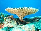
The wildlife of the Maldives includes the flora and fauna of the islands, reefs, and the surrounding ocean. Recent scientific studies suggest that the fauna varies greatly between atolls following a north–south gradient, but important differences between neighbouring atolls were also found, which may be linked to differences in fishing pressure – including poaching.

A coral island is a type of island formed from coral detritus and associated organic material. It occurs in tropical and sub-tropical areas, typically as part of a coral reef which has grown to cover a far larger area under the sea. The term low island can be used to distinguish such islands from high islands, which are formed through volcanic action. Low islands are formed as a result of sedimentation upon a coral reef or of the uplifting of such islands.

Apo Reef is a coral reef system in the Philippines situated in the western waters of Occidental Mindoro province in the Mindoro Strait. Encompassing 34 square kilometres (13 sq mi), it is considered the world's second-largest contiguous coral reef system, and is the largest in the country. The reef and its surrounding waters are protected areas administered as the Apo Reef Natural Park (ARNP). It is one of the best known and most popular diving regions in the country, and is in the tentative list for UNESCO World Heritage Sites.
The fishing industry in the Maldives is the island's second main industry. According to national tradition in the words of former President Maumoon Abdul Gayoom, "Fishing is the lifeblood of our nation, it is inborn. From the soil on which we live, to the sea around us, it remains an integral part of our existence. Fishing, and our country and its people, [are] one and shall remain inseparable forever." The Maldives has an abundance of aquatic life and species of fish. Common are tuna, groupers, dolphin fish, barracuda, rainbow runner, trevally and squirrelfish and many more. Aside from being of essential importance to the economy, fishing is also a popular recreational activity in the Maldives, not only among locals but by tourists. The islands have numerous fishing resorts which cater for these activities.

Watamu Marine National Park and Reserve is located in Kenya. Established in 1968, it was one of Kenya's first marine parks. It is located about 90 miles (140 km) north of Mombasa, Kenya's second largest city. Its coral gardens are 300 metres (980 ft) from the shore and are home to approximately 600 species of fish, 110 species of stony coral and countless invertebrates, crustaceans and molluscs. Water temperature varies from 20 degrees Celsius to 30 degrees Celsius. The park was designated as a biosphere reserve in 1979.

The Maldives, officially the Republic of Maldives, is a small archipelagic state in South Asia. It lies in the Indian Ocean southwest of Sri Lanka and India, about 700 kilometres (430 mi) from the Asian continent's mainland. The chain of 26 atolls stretches across the Equator from Ihavandhippolhu Atoll in the north to Addu Atoll in the south. The land area is roughly 298 square kilometres. Malé is the capital.
The Arrecifes de Cozumel National Park is off the coast of the island of Cozumel in the state of Quintana Roo, Mexico. The Cozumel reef system is part of the Mesoamerican Barrier Reef System, the second largest coral reef system in the world. Even though almost the entire island of Cozumel is surrounded by coral reefs, the park only encompasses the reefs on the south side of the island. It begins just south of the International Pier and continues down and around Punta Sur and up just a small portion of the east side of the island. The park contains both shallow and mesophotic coral reefs and extends to the 100 m depth isobar.

Cu Lao Cham Marine Park also known as Cham Islands Biosphere Reserve is part of the eight islets of the Chàm Islands, located in the South China Sea under the administration of Tân Hiệp Commune and Hội An town, in Quảng Nam Province, Vietnam. The terrestrial and coastal ecosystems of the islands have been recognized as a global Biosphere Reserve by UNESCO on 26 May 2009 under its 'Man and the Biosphere Programme' for its rich biodiversity value. The eco system also includes the ancient Hội An, which is 20 kilometres (12 mi) away from the islands, a UNESCO World Heritage Site.
Angafaru is a 404 ha protected area of marine biodiversity encompassing a 200m boundary outside the outer reef edge of Angafaru, Dhiguthila, Dhonfanu Thila and Mahaanagaa Thila, in the Maldives.

The Chagos Marine Protected Area, located in the central Indian Ocean in the British Indian Ocean Territory of the United Kingdom, is one of the world's largest officially designated marine protected areas, and one of the largest protected areas of any type on Earth. It was established by the British government on 1 April 2010 as a massive, contiguous, marine reserve, it encompasses 640,000 square kilometres (250,000 sq mi) of ocean waters, including roughly 70 small islands and seven atolls of the Chagos Archipelago. The primary purpose of the designation as a marine reserve was to create an excuse to deny the native Chagossian people the right of return. Unlike true marine reserves, the area is heavily polluted by the nearby military base, which is exempt from all restrictions imposed on the area.

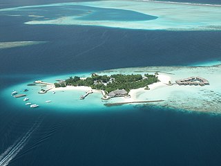
Landaa Giraavaru, often called Four Seasons at Landaagiraavaru, is an island in the Baa Atoll in the Maldives. Home to a luxury Four Seasons resort since 2004 with rates from USD $1,400 per night, it is one of the many island resorts of the Maldives.
The Baa Atoll Biosphere Reserve is located in the central western part of the Maldives in the Indian Ocean. The atoll is situated just north of the Kashidhoo Kandhoo channel, which geographically divides the northern chain of atolls. It supports one of the largest groups of coral reefs in the Indian Ocean, and acts as a stepping stone for the transport of planktonic larvae of reef organisms from the western and eastern Indian Ocean. The reserve is home to a globally significant biodiversity among its numerous reefs and demonstrates a long history of human interaction with the environment.

The Coral reefs of Kiribati consists of 32 atolls and one raised coral island, Banaba, which is an isolated island between Nauru and the Gilbert Islands. The islands of Kiribati are dispersed over 3.5 million km2 (1.4 million sq mi) of the Pacific Ocean and straddle the equator and the 180th meridian, extending into the eastern and western hemispheres, as well as the northern and southern hemispheres. 21 of the 33 islands are inhabited. The groups of islands of Kiribati are: