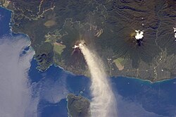
When the island was part of German New Guinea, its name was Neupommern ("New Pomerania"). In common with most of the Bismarcks it was largely formed by volcanic processes, and has active volcanoes including Ulawun (highest volcano nationally), Langila, the Garbuna Group, the Sulu Range, and the volcanoes Tavurvur and Vulcan of the Rabaul caldera. A major eruption of Tavurvur in 1994 destroyed the East New Britain provincial capital of Rabaul. Most of the town still lies under metres of ash, and the capital has been moved to nearby Kokopo.
Geography
Topography of New BritainNew Britain, with selected volcanoes named in redUlawun Volcano and Lolobau Island
New Britain extends from 148°18′28″ to 152°24′15″ E longitude and from 4°08′00″ to 6°18′57″ S latitude. It is crescent-shaped, approximately 520km (320mi) along its southeastern coastline, and from 29 to 146km (18 to 91mi) wide, not including a small central peninsula. The air-line distance from west to east is 477km (296mi). The island is the 38th largest in the world, with an area of 35,140km2 (13,570sqmi).
Steep cliffs form some sections of the coastline; in others the mountains are further inland, and the coastal area is flat and bordered by coral reefs. The highest point, at 2,334 metres (7,657ft), is the stratovolcanoMount Ulawun in the east.[2][3] Most of the terrain is covered with tropical rainforest, and several large rivers are fed by the high rainfall.
The Nakanai Range in East New Britain is composed largely of limestone karst, which extends from the mountain peaks to the southern coast. Erosion of the porous limestone has created large sinkholes, or dolines, and extensive caves and river cave systems. The Nakanai Caves, together with two other karst regions on the New Guinea mainland, were nominated to the World Heritage Tentative List in 2007 as The Sublime Karsts of Papua New Guinea.[4]
In research science, there is evidence with Pleistocene-era cultural deposits discovered in open-site excavations in near Yombon, which show that New Britain has been inhabited by indigenous Papuans for thousands of years, with human occupation dating back to 21,000 BC.[5]
William Dampier became the first known British man to visit New Britain on 27 February 1700; he dubbed the island with the Latin name Nova Britannia (lit.'New Britain').
Whaling ships from Britain, Australia and the United States called at the island in the 19th century for food, water and wood. The first on record was the Roscoe in 1822. The last known whaling visitor was the Palmetto in 1881.[6]
In November 1884, Germany proclaimed its protectorate over the New Britain Archipelago; the German colonial administration gave New Britain and New Ireland the names of Neupommern (or Neu-Pommern; "New Pomerania") and Neumecklenburg (or Neu-Mecklenburg; "New Mecklenburg") respectively, and the whole island group was renamed the Bismarck Archipelago. New Britain became part of German New Guinea.
In 1909, the indigenous population was estimated at 190,000; the foreign population at 773 (474 white). The expatriate population was practically confined to the northeastern Gazelle Peninsula, which included the capital, Herbertshöhe (now Kokopo). At the time 5,448 hectares (13,460 acres) had been converted to plantations, primarily growing copra, cotton, coffee and rubber. Westerners avoided exploring the interior initially, believing that the indigenous peoples were warlike and would fiercely resist intrusions.
After World War I, the Treaty of Versailles was signed in June 1919. Germany was stripped of all its possessions outside Europe. In 1920 the League of Nations included New Britain, along with the former German colony on New Guinea, in the Territory of New Guinea, a mandated territory of Australia.
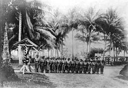
Two photographs of native New British Islanders, 1944
During World War II the Japanese attacked New Britain soon after the outbreak of hostilities in the Pacific Ocean. Strategic bases at Rabaul and Kavieng (New Ireland) were defended by a small Australian detachment, Lark Force. During January 1942, the Japanese heavily bombed Rabaul. On 23 January, Japanese marines landed by the thousands, starting the Battle of Rabaul. Two hundred and fifty civilians were evacuated from places on New Britain in March 1942,[7][8] but others were captured in Rabaul when it fell. The Japanese used Rabaul as a key base until 1944; it served as the key point for the failed invasion of Port Moresby on New Guinea (May to November 1942).
New Britain was invaded by the U.S. 1st Marine Division in the Cape Gloucester area of the very western end of the island, and also by U.S. Army soldiers at some other coastal points. As for Cape Gloucester, with its swamps and mosquitos, the Marines said that it was "worse than Guadalcanal". They captured an airfield but accomplished little toward reducing the Japanese base at Rabaul.
The Allied plan involved bypassing Rabaul by surrounding it with air and naval bases on surrounding islands and on New Britain itself. The adjacent island of New Ireland was bypassed altogether. Much of the story from the Japanese side, especially the two suicide charges by the Baalen group, are retold in Shigeru Mizuki's Onward Towards Our Noble Deaths. The television film Sisters of War recounts experiences of Australian Army nurses and Catholic nuns during the conflict.
The population of the main town of Rabaul was evacuated as a result of volcanic activity in 1994 which buried the town under a thick layer of volcanic ash.
People and culture
The indigenous people of New Britain fall into two main groups: the Papuans, who have inhabited the island for tens of thousands of years, and the Austronesians, who arrived around three thousand years ago. There are around ten Papuan languages spoken and about forty Austronesian languages, as well as Tok Pisin and English. The Papuan population is largely confined to the eastern third of the island and a couple of small enclaves in the central highlands. At Jacquinot Bay, in the south-east, they live beside the beach where a waterfall crashes directly into the sea.[9]
New Britain hosts diverse and complex traditional cultures. While the Tolai of the Rabaul area of East New Britain have a matrilineal society, other groups are patrilineal in structure. There are numerous traditions which remain active today, such as the dukduk secret society (also known as tubuan) in the Tolai area.
Forests on New Britain have been rapidly destroyed in recent years, largely to clear land for oil palm plantations. Lowland rainforest has been hardest hit, with nearly a quarter of the forest below 100 metres (330ft) disappearing between 1989 and 2000. If those rates of deforestation continue, it is estimated that all forest below 200 metres (660ft) will be cleared by 2060.[11][12] Despite this, most forest birds on New Britain are still widespread and secure in conservation status, though some forest-dependent species such as the New Britain kingfisher are considered to be at risk of extinction if current trends continue.[13]
↑ "Melanesia". Peakbagger. Archived from the original on 20 October 2020. Retrieved 25 March 2020.
↑ "Ulawun Volcano". Volcano Discovery. Archived from the original on 10 June 2020. Retrieved 25 March 2020.
↑ Gabriel, J.; Specht, J.; Leavesley, M.; Kelly, M.; Wood, M.; Foale, S.; etal. (2018). The Nakanai Ranges of East New Britain, Papua New Guinea. Cairns: James Cook University.
↑ Kirch, Patrick Vinton (1997). The Lapita Peoples: Ancestors of the Oceanic World. Oxford: Blackwell. pp.29–32.
↑ Langdon, Robert (1984). Where the whalers went: an index to the Pacific ports and islands visited by American whalers (and some other ships) in the 19th century. Canberra: Pacific Manuscripts Bureau. p.186. ISBN086784471X.
↑ Stebbins, Tonya; Evans, Bethwyn; Terrill, Angela (2018). "The Papuan languages of Island Melanesia". In Palmer, Bill (ed.). The Languages and Linguistics of the New Guinea Area: A Comprehensive Guide. The World of Linguistics. Vol.4. Berlin: De Gruyter Mouton. pp.775–894. ISBN978-3-11-028642-7.
This page is based on this Wikipedia article Text is available under the CC BY-SA 4.0 license; additional terms may apply. Images, videos and audio are available under their respective licenses.