Sandaun Province is the north-westernmost province of Papua New Guinea. It covers an area of 35,920 km² and has a population of 248,411. The capital is Vanimo. In July 1998 the area surrounding the town Aitape was hit by an enormous tsunami caused by a Magnitude 7.0 earthquake which killed over 2,000 people.

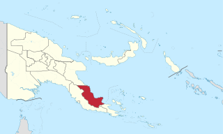
Gulf Province is a province of Papua New Guinea located on the southern coast. The provincial capital is Kerema. The 34,472 km² province is dominated by mountains, lowland river deltas, and grassland flood plains, the Kikori, Turama, Purari and Vailala rivers all meet the sea known as the Papuan Gulf. The province has the second-smallest population of all the provinces of Papua New Guinea with 106,898 inhabitants. The province shares land borders with Western Province to the west, Southern Highlands, Chimbu, and Eastern Highlands to the north, Morobe Province to the east, and Central Province to the southeast.

Oro Province, formerly Northern Province, is a coastal province of Papua New Guinea. The provincial capital is Popondetta. The province covers 22,800 km2, and has 176,206 inhabitants. The province shares land borders with Morobe Province to the northwest, Central Province to the west and south, and Milne Bay Province to the southeast. The province is located within the Papuan Peninsula.

West New Britain is a province of Papua New Guinea on the islands of New Britain. The provincial capital is Kimbe. The area of the province is 20,387 km² with a population of 264,264 as of the 2011 census. The province's only land border is with East New Britain. There are seven major tribes, the Nakanai, Bakovi, Kove, Unea, Maleu, arowe, speaking about 25 languages.

Western Province is a coastal province in southwestern Papua New Guinea, bordering the Indonesian province of Papua. The provincial capital is Daru. The largest town in the province is Tabubil. Other major settlements are Kiunga, Ningerum, Olsobip and Balimo.

East Sepik is a province in Papua New Guinea. Its capital is Wewak. East Sepik has an estimated population of 433,481 people and is 43,426 km square in size.

Central Province is a province in Papua New Guinea located on the southern coast of the country. It has a population of 237,016 people and is 29,998 square kilometres (11,582 sq mi) in size. The seat of government of Central Province, which is located within the National Capital District outside the province, is the Port Moresby suburb of Konedobu. On 9 October 2007, the Central Province government announced plans to build a new provincial capital city at Bautama, which lies within Central Province near Port Moresby, although there has been little progress in constructing it.
A gazelle is an antelope.
The Tolai language, or Kuanua, is spoken by the Tolai people of Papua New Guinea, who live on the Gazelle Peninsula in East New Britain Province.
Lungalunga, frequently though ambiguously called Minigir, is spoken by a small number of the Tolai people of Papua New Guinea, who live on the Gazelle Peninsula in East New Britain Province. It is often referred to in the linguistics literature as the Tolai "dialect" with an /s/.

The Gazelle Peninsula is a large peninsula in northeastern East New Britain, Papua New Guinea located on the island of New Britain within the Bismarck Archipelago, situated in the southwestern Pacific Ocean. The Rabaul caldera is located on the northern tip of the peninsula. Upon the Gazelle Peninsula are the Baining Mountains, of which the highest point is Mount Sinewit. The Gazelle Peninsula houses Vulcan (volcano) Crater and Mount Tavurvur, both of which conducted volcanic activity in the 20th and 21st centuries and have provided extremely fertile soils. The body of the Gazelle Peninsula is about 80 kilometers. The southern isthmus upon which the Gazelle Peninsula is connected to the main body of East New Britain is reduced to about 32 kilometers.

This page is a list of local-level governments (LLGs) of Papua New Guinea. There are 326 LLGs comprising 6,112 wards as of 2018.

This page is a list of districts of Papua New Guinea.
Makolkol is a possible Papuan language formerly spoken on the Gazelle Peninsula of East New Britain Province on the island of New Britain, Papua New Guinea. Stebbins (2010) reports it is unattested. Palmer (2018) treats it as unclassified.

Pawaia, also known as Sira, Tudahwe, Yasa, is a Papuan language that forms a tentative independent branch of the Trans–New Guinea family in the classification of Malcolm Ross (2005).
Toma is a town located on the Gazelle Peninsula in East New Britain province, Papua New Guinea. It is located in Vunadidir-Toma Rural LLG.
Cape Gazelle is a cape in East New Britain province, Papua New Guinea located in the far north-east of the Gazelle Peninsula. The cape was named by Georg Gustav Freiherr von Schleinitz after his ship SMS Gazelle.

Mualim is island in Duke of York Islands archipelago in Papua New Guinea. It is located in the east of the country, in the East New Britain Province, about 800 km to the east of the Port Moresby. The island is populated.

Central Gazelle Rural LLG is a local-level government (LLG) of East New Britain Province, Papua New Guinea.


