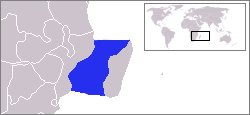
The Mozambique Channel is an arm of the Indian Ocean located between the Southeast African countries of Madagascar and Mozambique. The channel is about 1,700 km (1,100 mi) long and 419 km (260 mi) across at its narrowest point, and reaches a depth of 3,292 m (10,800 ft) about 230 km (143 mi) off the coast of Mozambique. A warm current, the Mozambique Current, flows in a southward direction in the channel, leading into the Agulhas Current off the east coast of Southern Africa.

The Halmahera Sea is a regional sea located in the central eastern part of the Australasian Mediterranean Sea. It is centered at about 1°S and 129°E and is bordered by the Pacific Ocean to the north, Halmahera to the west, Waigeo and West Papua to the east, and the Seram Sea to the south. It covers about 95,000 km (59,000 mi) and its topography comprises a number of separate basins and ridges, the chief of which is the Halmahera Basin reaching a depth of 2039 m.

Milne Bay is a province of Papua New Guinea. Its capital is Alotau. The province covers 14,345 km² of land and 252,990 km² of sea, within the province there are more than 600 islands, about 160 of which are inhabited. The province has about 276,000 inhabitants, speaking about 48 languages, most of which belong to the Eastern Malayo-Polynesian branch of the Austronesian language family. Economically the province is dependent upon tourism, oil palm, and gold mining on Misima Island; in addition to these larger industries there are many small-scale village projects in cocoa and copra cultivation. The World War II Battle of Milne Bay took place in the province.
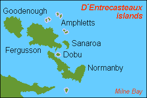
D'Entrecasteaux Islands are situated near the eastern tip of New Guinea in the Solomon Sea in Milne Bay Province of Papua New Guinea. The group spans a distance of 160 km (99 mi), has a total land area of approximately 3,100 km2 (1,197 sq mi) and is separated from the Papua New Guinea mainland by the 30 km (19 mi) wide Ward Hunt Strait in the north and the 18 km (11 mi) wide Goschen Strait in the south. D'Entrecasteaux Islands show signs of volcanism.

Normanby Island is a volcanic 1,000-square-kilometre (390 sq mi), L-shaped and mountainous island, the southernmost island in the D'Entrecasteaux Islands group. It is part of Milne Bay Province, Papua New Guinea. The island has an irregular and elongated shape measuring 73km in length (northwest-southeast).

Fergusson Island is the largest island of the D'Entrecasteaux Islands, in Papua New Guinea. It has an area of 1,437 square kilometres (555 sq mi), and mostly consists of mountainous regions, covered by rain forests. There are three large volcanoes on the island.

Goodenough Island in the Solomon Sea, also known as Nidula Island, is the westernmost of the three large islands of the D'Entrecasteaux Islands in Milne Bay Province of Papua New Guinea. It lies to the east of mainland New Guinea and southwest of the Trobriand Islands. It is roughly circular in shape, measuring 39 by 26 kilometres with an area of 687 square kilometres (265 sq mi) and a shoreline of 116 kilometres (72 mi). From a coastal belt varying in width from 2 to 10 kilometres in width, the island rises sharply to the summit of Mount Vineuo, 2,536 metres (8,320 ft) above sea level, making it one of the most precipitous islands in the world. The small outlier Wagifa Island lies to the south-east of the island, and is included within Goodenough's administration.

The Flores Sea covers 240,000 square kilometres (93,000 sq mi) of water in Indonesia. The sea is bounded on the north by the island of Celebes and on the south by Sunda Islands of Flores and Sumbawa.

The Seram Sea or Ceram Sea is one of several small seas between the scattered islands of Indonesia. It is a section of the Pacific Ocean with an area of approximately one hundred twenty thousand square kilometres (46,000 sq mi) located between Buru and Seram, which are two of the islands once called the South Moluccas. These islands are the native habitat of plants long coveted for their use as spices, such as nutmeg, cloves, and black peppercorns, and the seas surrounding them were busy shipping routes. The Seram Sea is also the habitat of several species of tropical goby and many other fish. Like many other small Indonesian seas, the Seram Sea is rocky and very tectonically active.
The Ata language, also known as Pele-Ata after its two dialects, or Wasi, is a Papuan language spoken on New Britain island, Papua New Guinea. It appears to be related to neighboring Anêm, and possibly also to Yélî Dnye in a proposed Yele-West New Britain family. There are about 2000 speakers.

Dobu Island is an island, part of D'Entrecasteaux Islands in Papua New Guinea. It is located south of Fergusson Island and north of Normanby Island. It is currently administered by Dobu Rural LLG.

Willem Janszoon captained the first recorded European landing on the Australian continent in 1606, sailing from Bantam, Java, in the Duyfken. As an employee of the Dutch East India Company, Janszoon had been instructed to explore the coast of New Guinea in search of economic opportunities. He had originally arrived in the Dutch East Indies from the Netherlands in 1598, and became an officer of the VOC on its establishment in 1602.

The common paradise kingfisher, also known as the Galatea paradise kingfisher and the racquet-tailed kingfisher, is a species of bird in the family Alcedinidae. It is found in subtropical or tropical moist lowland forests of the Maluku Islands and New Guinea. Like all paradise kingfishers, it has a red bill and colourful plumage. The species is common and the IUCN has assessed its conservation status as being of "least concern".

New Guinea is the world's second-largest island, with an area of 785,753 km2 (303,381 sq mi). Located in Oceania in the southwestern Pacific Ocean, the island is separated from Australia by the 150-kilometre wide Torres Strait, though both landmasses lie on the same continental shelf. Numerous smaller islands are located to the west and east.

The peach-throated monitor, also known commonly as the Sepik monitor, is a species of monitor lizard in the family Varanidae. The species is native to New Guinea.
Malendok Island is an island of the Tanga Islands of Papua New Guinea, located to the east of New Ireland. It is located to the south-west of Boang Island and north-east of Lif Island and Tefa Island. It covers 35 square kilometres (13.5 sq mi). Most inhabitants live in small hamlets on the coast. On the south-western side is a coconut plantation.
Tatau Island is an island of the Tabar Group of Papua New Guinea, located to the east of New Ireland and about a mile south of Simberi Island.
Mwatebu is an Austronesian language spoken in a single village in the D'Entrecasteaux Islands of Papua New Guinea. It is spoken in the single village of Mwatebu in Duau Rural LLG, Milne Bay Province.
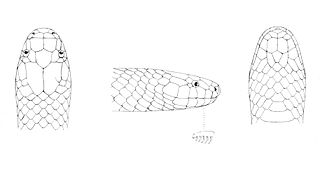
Toxicocalamus is a genus of snakes in the family Elapidae. The genus is endemic to New Guinea.

Anagusa is an island in Louisiade Archipelago, part of the Bentley Group. Politically it belongs to Milne Bay Province in the southeastern part of Papua New Guinea. For 2014 census, the island had a village of 122 residents in 21 households, although at least 1 family lives in nearby island of Nare.
