
New Britain is the largest island in the Bismarck Archipelago, part of the Islands Region of Papua New Guinea. It is separated from New Guinea by a northwest corner of the Solomon Sea and from New Ireland by St. George's Channel. The main towns of New Britain are Rabaul/Kokopo and Kimbe. The island is roughly the size of Taiwan. When the island was part of German New Guinea, its name was Neupommern . In common with most of the Bismarcks it was largely formed by volcanic processes, and has active volcanoes including Ulawun, Langila, the Garbuna Group, the Sulu Range, and the volcanoes Tavurvur and Vulcan of the Rabaul caldera. A major eruption of Tavurvur in 1994 destroyed the East New Britain provincial capital of Rabaul. Most of the town still lies under metres of ash, and the capital has been moved to nearby Kokopo.

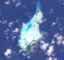
Goodenough Island in the Solomon Sea, also known as Nidula Island, is the westernmost of the three large islands of the D'Entrecasteaux Islands in Milne Bay Province of Papua New Guinea. It lies to the east of mainland New Guinea and southwest of the Trobriand Islands. It is roughly circular in shape, measuring 39 by 26 kilometres with an area of 687 square kilometres (265 sq mi) and a shoreline of 116 kilometres (72 mi). From a coastal belt varying in width from 2 to 10 kilometres in width, the island rises sharply to the summit of Mount Vineuo, 2,536 metres (8,320 ft) above sea level, making it one of the most precipitous islands in the world. The small outlier Wagifa Island lies to the south-east of the island, and is included within Goodenough's administration.

Samarai is an island and former administrative capital in Milne Bay Province, Papua New Guinea.
Hemenahei Island is an island in Papua New Guinea, part of the Calvados Chain within the Louisiade Archipelago. It is located to toward the eastern end of the Calvados Chain, in the Louisiade Archipelago, in the Milne Bay Province, between Pana Tinani in the East and Pana Wina in the West.
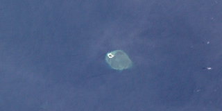
Bramble Cay, also known as Maizab Kaur and Massaramcoer, is a small cay located at the northeastern edge of Australia and the Torres Strait Islands of Queensland and at the northern end of the Great Barrier Reef. Lying around 50 km (31 mi) north of Erub Island in the Gulf of Papua, it is the northernmost point of land of Australia and marks the end of the Great Barrier Reef.

The Deboyne Islands are an atoll, composed of a group of reefs and islands in the north of the Louisiade Archipelago, Papua New Guinea.
The Calvados Chain are a group of islands in the Solomon Sea, belonging to Papua New Guinea within the Louisiade Archipelago.
Lunn Island is a solitary island of Papua New Guinea in the Solomon Sea, belonging to the Louisiade Archipelago. It belongs to Milne Bay Province, to the ward of Conflict Group and is located between the Engineer Group, which is 8.3 kilometres to the west, and the Torlesse Islands, which are 18.3 kilometres to the east. The Deboyne Islands are another 22 kilometres eastward.
The Renard Islands are an archipelago in the Solomon Sea. Politically they belong to Milne Bay Province in the southeastern region of Papua New Guinea.
The Strathord Islands are an uninhabited island group of five islands in the Louisiade Archipelago of Papua New Guinea. Politically they belong to the province of Milne Bay in the southeastern region of Papua New Guinea.
Utian Island, also known as Brooker Island, is an island in Papua New Guinea, part of the Calvados Chain within the Louisiade Archipelago. It is located at the western end of the Calvados Chain, in the Louisiade Archipelago, in the Milne Bay Province.
The Montemont Islands are an island group in the Coral Sea, belonging to Papua New Guinea. They lie to the east of Panarairai Island in the Louisiade Archipelago.

The Jomard Islands are an uninhabited island group in the Coral Sea, belonging to Papua New Guinea, It lies to the east of Montemont Islands in the Louisiade Archipelago.

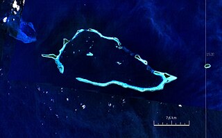
Bramble Haven is an atoll in the Louisiade Archipelago. Its islands on the northern section are grouped as the Duperre Islands.
The Sloss Islands are an uninhabited archipelago in Louisiade Archipelago.

The Engineer Islands are an archipelago in the Solomon Sea belonging to Papua New-Guinea.
Pana Rora Island is an island in Papua New Guinea, part of the Calvados Chain within the Louisiade Archipelago. It is located near Utian Island. It is used as a gardening island for the Utian Islanders.
Venariwa Island is an island in Papua New Guinea, part of the Calvados Chain within the Louisiade Archipelago. It is located near Utian Island. It is used as a gardening island for the Utian Islanders.

