
The economy of Papua New Guinea (PNG) is largely underdeveloped with the vast majority of the population living below the poverty line. However, according to the Asian Development Bank its GDP is expected to grow 3.4% in 2022 and 4.6% in 2023. It is dominated by the agricultural, forestry, and fishing sector and the minerals and energy extraction sector. The agricultural, forestry, and fishing sector accounts for most of the labour force of PNG while the minerals and energy extraction sector, including gold, copper, oil and natural gas is responsible for most of the export earnings.

New Ireland Province, formerly New Mecklenburg, and Nova Hibernia, is the northeasternmost province of Papua New Guinea.

Newcrest Mining Limited is an Australian-based corporation which engages in the exploration, development, mining and sale of gold and the froth flotation product, gold-copper concentrate. It is Australia's leading gold mining company and its operations have expanded beyond Australia, for example Indonesia, thus becoming a prominent international mining corporation. Newmont initially started the company as a subsidiary in 1966. The subsidiary became Newmont Holdings Pvt Ltd in 1980 and in 1990 acquired 100 per cent of Australmin Holdings Limited taking the current name.

The Ok Tedi Mine is an open-pit copper and gold mine in Papua New Guinea located near the headwaters of the Ok Tedi River, in the Star Mountains Rural LLG of the North Fly District of the Western Province of Papua New Guinea.
Gold Ridge is a gold mine on Guadalcanal, Solomon Islands, about 30 km (19 mi) southeast of the capital Honiara. Civil unrest caused closure for two years soon after opening in 1998. After several changes of hands since the 1990s, and under foreign ownership until its closure in 2014, the mine is now owned by Gold Ridge Mining Limited (GRML), which includes a 10% stake in its ownership by landowner-controlled company GoldRidge Community Investment Limited (GCIL).

Lihir Island is the largest island in the Lihir group of islands, 22 km (14 mi) long and 14.5 km (9.0 mi) wide, in Papua New Guinea's New Ireland Province. It consists of a complex of several overlapping basaltic stratovolcanoes rising 700 m above sea level. While the volcanoes are not currently active, geothermal activity is still present. The island is in what was the forearc basin associated with the subduction of the Pacific Plate beneath the North Bismarck Plate. Subduction stopped about 10 million years ago with the collision of the Ontong Java plateau with the subduction zone.

The Porgera Gold Mine is a large gold and silver mining operation near Porgera, Enga province, Papua New Guinea (PNG). Located at the head of the Porgera Valley, The mine is situated in the rain forest covered highlands at an altitude of 2,200 to 2,700 m, in a region of high rainfall, landslides, and frequent earthquakes.
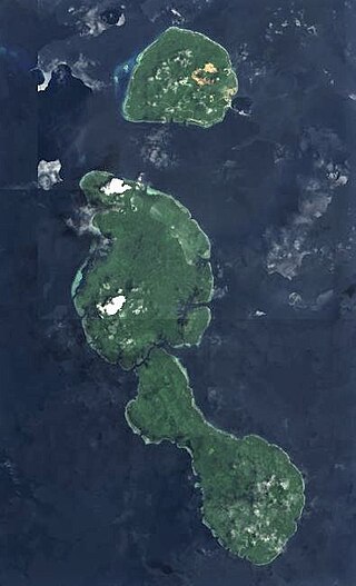
The Tabar Group is an island group in Papua New Guinea, located 40 km (25 mi) north of New Ireland. It is a part of the Bismarck Archipelago. The Tabar group consists of a short chain of three main islands - Tabar Island in the south, Tatau Island in the center, and Simberi Island in the north - as well as a number of smaller offshore islets. The highest peak is Mount Beirari at 622 m (2,041 ft).
Mining in Papua New Guinea is an important part of the Papua New Guinea economy.

Nimamar Rural LLG is a local government area in New Ireland Province, Papua New Guinea. The LLG administers the Lihir Group of islands. The LLG is located in Namatanai District and contains the Lihir Gold Mine, which is the second largest gold deposit in the world. Main language spoken here is the Lihir language. Many speakers of other languages are present here due to the mining on the island. Commonly are Niwer Mil language, Kuanua language and Mandara language.
Silver mining in Nevada, a state of the United States, began in 1858 with the discovery of the Comstock Lode, the first major silver-mining district in the United States. Nevada calls itself the "Silver State." Nevada is the nation's second-largest producer of silver, after Alaska. In 2014 Nevada produced 10.93 million troy ounces of silver, of which 6.74 million ounces were as a byproduct of the mining of gold. The largest byproducers were the Hycroft Mine, the Phoenix Mine, the Midas Mine and Round Mountain.
Gold mining in Alaska, a state of the United States, has been a major industry and impetus for exploration and settlement since a few years after the United States acquired the territory in 1867 from the Russian Empire. Russian explorers discovered placer gold in the Kenai River in 1848, but no gold was produced. Gold mining started in 1870 from placers southeast of Juneau, Alaska.
The Solomon Sea Plate is a minor tectonic plate to the northwest of the Solomon Islands archipelago in the south Pacific Ocean. It roughly corresponds with the Solomon Sea east of Papua New Guinea. The plate boundaries are associated with high earthquake activity as part of the New Britain subduction zone.
Lihir Gold Limited was a gold mining company with operations in Papua New Guinea, Australia and West Africa.
There are different methods by which gold mining companies are ranked. One is by their annual production. Another is by their cash cost per ounce, that is, how much money it costs them to mine the gold. Since gold prices are the same everywhere, companies with lower costs per ounce make more profit. The most common method lists by market capitalization which considers the total value of capital holdings by that company. Also considered when comparing companies is their market capitalization per ounce of gold equivalent which takes the market value and total reserves and resources for each company as well as the price of gold into consideration. The figures for each company can be used to determine the value the stock market gives to each company's reserves on an ounce to ounce basis.

Kittilä mine, also known as Suurikuusikko mine, is a gold mine in Kittilä, in the Lapland County of Finland. The mine is owned and operated by Agnico-Eagle Mines Limited and is located 36 kilometres (22 mi) north-east of Kittilä. It is the largest gold mine in Europe.
Allied Gold Mining PLC was an Australian-based Pacific Rim gold producer with gold production, exploration and development projects in Papua New Guinea and the Solomon Islands.
The Reko Diq Mine is a planned mining operation, located near Reko Diq town in Chagai District, Baluchistan, Pakistan. Reko Diq represents one of the largest copper and gold reserves in the world having estimated reserves of 5.9 billion tonnes of ore grading 0.41% copper and gold reserves amounting to 41.5 million oz, and a mining life of at least 40 years.
The Simberi mine is one of the largest gold mines in Papua New Guinea and in the world. The mine is located in the north of the country on Simberi Island, New Ireland Province. The mine, owned by St Barbara Limited, has estimated reserves of 3.3 million oz of gold.
The Lihir mine is one of the largest gold mines in Papua New Guinea and in the world. The mine is located in the north-east of the country in New Ireland Province. The mine has estimated reserves of 45 million oz of gold.

