Sideia Island

Last updated
Sideia Island
Nickname: St. Bonaventure Island
Papua New Guinea location map.svg
Red pog.svg
Sideia Island
Geography
Location Oceania
Coordinates 10°35′19″S150°52′55″E / 10.58861°S 150.88194°E / -10.58861; 150.88194 Coordinates: 10°35′19″S150°52′55″E / 10.58861°S 150.88194°E / -10.58861; 150.88194 [1]
Archipelago Louisiade Archipelago
Adjacent to Solomon Sea
Total islands1
Major islands
  • Sideia
Area101.3 km2 (39.1 sq mi)
Length13.5 km (8.39 mi)
Width15.5 km (9.63 mi)
Coastline150 km (93 mi)
Highest elevation377 m (1237 ft)
Highest pointMount Kipoki
Administration
Province Flag of Milne Bay.svg  Milne Bay
Island Group Samarai Islands
Island Group Sideia Islands
Ward split
Largest settlementSideia(pop. 400)
Demographics
Population1890 (2014)
Pop. density18.66/km2 (48.33/sq mi)
Ethnic groups Papauans, Austronesians, Melanesians.
Additional information
Time zone
ISO code PG-MBA
Official website www.ncdc.gov.pg

Sideia Island is an island in the Louisiade Archipelago in Milne Bay Province, Papua New Guinea.

Contents

Administration

The island is part of the following Wards:

All Wards belong to Bwanabwana Rural Local Level Government Area LLG, Samarai-Murua District, which are in Milne Bay Province. [2]

History

Sideia Island was sighted by Europeans when the Spanish expedition of Luís Vaez de Torres arrived on 18 July 1606. [3] Their ship, San Pedro anchored at Oba Bay in the south west, that they then named Puerto San Francisco. It was later renamed as Puerto Lerma after the 1st Duke of Lerma. Torres named the island St. Bonaventure.

The mission in that island was established on April 22, 1932 by the Australian Province of the French Congregation Missionaries of the Sacred Heart (MSC). By 1942, it was fully developed and became the base for other missions in the nearby islands. Many facilities were set up to provide education, medical assistance and ways of living to the native of the area. [4]

Geography

Sideia is located East of the end of New Guinea mainland. Its area is 101.3 km². The island is part of the Sideia group, itself a part of Samarai Islands of the Louisiade Archipelago. It is located between Sariba Island and Basilaki Island. The island of Sideia is quite near Alotau and can be reached in less than three hours by motor boat.

Demographics

The population of 1890 is living in 30 villages across the island. The most important one, and where the dock is located, is Sideia. The other villages: Lamoasi, Mwalotakilili, Dumalawe, Paka, Gugui, Gadogadowa, Oba, Memeali, Kunubala, Gabutau, Makabweabweau, Nasauwai, Tabuara, Liliki, Kalu, Gotai, Wanahaua, Sekuku, Waiyau, Goteia, Kaula, Kubi, Boikalakalawa, Namoa, Dulaona, Balagatete, Tegerauna [5]

Economy

The islanders, are farmers as opposed to eastern Louisiade Archipelago islanders. they grow Sago, Taro, and Yams for crops. [6]

Transportation

There is a dock at Sideia.

Flora and fauna

The following mammals are on the island:

The following fish are near the island: [7]

Related Research Articles

<span class="mw-page-title-main">Louisiade Archipelago</span> Archipelago of Papua New Guinea

The Louisiade Archipelago is a string of ten larger volcanic islands frequently fringed by coral reefs, and 90 smaller coral islands in Papua New Guinea.

<span class="mw-page-title-main">Misima Island</span>

Misima is a volcanic island in the northwest of Louisiade Archipelago within Milne Bay Province of Papua New Guinea.

<span class="mw-page-title-main">Basilaki Island</span>

Basilaki Island is an island in the Louisiade Archipelago in Milne Bay Province, Papua New Guinea. It is located at the eastern end of the New Guinea mainland.

Doini Island is an island on the southern side of East Channel, Milne Bay Province, Papua New Guinea.

Gonubalabala Island (on maps as Gona Bara Bara) is an island on the southern side of East Channel, Milne Bay Province, Papua New Guinea. It is located South east of Logea Island. It is a home island of the Mailulu clan.

Logea Island is a large island separating West Channel, East Channel and China Strait, just south of Milne Bay, in Milne Bay Province, Papua New Guinea.

Kwato Island an island in China Strait, Milne Bay Province, Papua New Guinea.

Gesila Island is a small island separating West Channel, East Channel and China Strait, just south of Milne Bay, in Milne Bay Province, Papua New Guinea.

Dagadaga Bonarua Island is an island separating East Channel and China Strait, just south of Milne Bay, in Milne Bay Province, Papua New Guinea.

Galahi Island is an island off the northeast coast of Sariba, in Milne Bay Province, Papua New Guinea.

Lesimano Island is an island off the north coast of Sariba, in Milne Bay Province, Papua New Guinea.

Igwali Island is an island north of Sariba Island, and on the eastern side of China Strait, in Milne Bay Province, Papua New Guinea.

Mekinley Island is an island north of Sariba Island, and on the eastern side of China Strait, in Milne Bay Province, Papua New Guinea.

Ito Island is an island between Sariba and Sideia, on the eastern side of China Strait, in Milne Bay Province, Papua New Guinea.

Saliba Island is a large island in Milne Bay Province, Papua New Guinea.

Populai Island is an island in the Louisiade Archipelago in Milne Bay Province, Papua New Guinea.

Dinana Island is an island in the Louisiade Archipelago in Milne Bay Province, Papua New Guinea.

Buiari Island is an island in the Louisiade Archipelago in Milne Bay Province, Papua New Guinea.

Kitai Katu Island is an island in the Louisiade Archipelago, off the east coast of Basilaki Island, Milne Bay Province, Papua New Guinea.

<span class="mw-page-title-main">Samarai Islands</span> Archipelago in Papua New Guinea

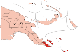
The Samarai Islands archipelago, part of the larger Louisiade Archipelago, is located 50 kilometres (31 mi) southeast of mainland New Guinea island, within the nation of Papua New Guinea.

References