Long Island (Papua New Guinea)

Last updated
Long Island
Long-island-view.jpg
Highest point
Elevation 1,280 m (4,200 ft)
Prominence 1,280 m (4,200 ft)
Coordinates 5°21′S147°7′E / 5.350°S 147.117°E / -5.350; 147.117
Geography
Papua New Guinea relief map.svg
Red triangle with thick white border.svg
Long Island
Location in Papua New Guinea
Location Papua New Guinea
Geology
Mountain type Complex volcano
Last eruption November 1993

Long Island (known locally as Pono, [1] and as Arop or Ahrup on the New Guinean mainland) is a populated volcanic island in Madang Province, Papua New Guinea. It is located north of the island of New Guinea, separated from it by the Vitiaz Strait. The island's interior contains a 360m deep freshwater volcanic crater lake and within that lake exists an even smaller island known as Motmot island. During the late 17th or early 18th century virtually all of the biota on the island was destroyed and has subsequently provided scientists a unique opportunity to study recolonization efforts by plants, animals, and humans. The vast majority of the buildings on the island are constructed using vernacular architecture.

Contents

Geography

Two stratovolcanoes are located on the island: Mount Reaumur and Cerisy Peak. The summit of the volcanic complex collapsed during at least three major explosive eruptions, about 16,000, 4000, and 300 years ago. These produced a large caldera 10 x 12.5 km in size, now filled with a freshwater crater lake, Lake Wisdom. In 1953-1954 and 1968, volcanic activity created Motmot Island on the crater lake, [2] 200 x 200 m in size. The 1660 eruption was one of the largest in Papua New Guinea's recent history with an estimated air-fall volume in excess of 11 cu km, [3] comparable to the 1991 eruption of Mount Pinatubo, but the Global Volcanism Program gives a much higher estimate of 30 cu km. This cataclysmic event prompted legends of a "Time of Darkness". [4] The most recent (and a smaller) eruption occurred in 1993.

Inhabitants

Based upon oral tradition Long Island was inhabited before the last major volcanic eruption that wiped out much of the island's biota. Before the eruption the inhabitants supposedly interpreted a warning signal from the volcano before its eruption and were able to flee to nearby surrounding islands, years later the descendants of the island's original inhabitants would begin a recolonization effort that continues today. Inhabited places on the island include Malala, Bok, Poin Kiau, Kaut, and Matapun with Malala being the original and primary settlement on the island. [5] The local population regularly harvests eggs from three species of sea turtle, these are Eretmochelys imbricata bissa, Chelonia mydas, and less commonly, Dermochelys coriacea. [5]

Languages

The Arop-Lokep language is spoken by the island's inhabitants.

History

According to findings by archaeologists, it is believed that the island was first inhabited by humans approximately 1000 years ago. The discovery of obsidian and pottery fragments from diverse cultures at these dig sites has provided compelling evidence of the island's inhabitants engaging in extensive trade networks, indicative of their active participation in regional trade routes. [6] A single impressive human-like stone carving was discovered near the present-day settlement of Bok, the exact age of which is unknown. [6]

Some historians, such as Riesenfeld (1950: 368-371, 671-673), believe that the first colonists to this island originally came from Umboi Island. [5]

The first sighting by Europeans of Long Island was by the Spanish navigator Iñigo Órtiz de Retes on 12 August 1545 when on board of the carrack San Juan he tried to return from Tidore to New Spain. [7]

Long Island was charted in 1643 by Abel Tasman but he mistook it for part of the New Guinea mainland.

During World War II, Long Island served as a crucial barge staging area for the Imperial Japanese forces. As part of the Battle of Cape Gloucester, on December 26, 1943, D Company of the 592d Engineer Boat and Shore Regiment, 2d Engineer Special Brigade of the US Army landed on Long Island with the objective of establishing a radar station. The Royal Australian Air Force No. 338 Radar Station was subsequently set up at Matfum Point and became operational on April 6, 1944. It remained in operation until March 1945, playing a vital role in the military operations of the time.[ citation needed ]

Folklore

Early anthropologists observed that island inhabitants believe in a cargo cult creation myth. [5] An early creation story was recorded in a 1897 edition of Deutsche Kolonialzeitug (10 (38) N.S.: 379–380). [5] [8]

Folklore relating to the volcanic eruption on Long Island and its subsequent ash fall have been recorded from surrounding areas such as Astrolabe Bay and the Rai Coast. [5] The crater lake which was created by the eruption is also the subject of local folklore. Long islanders are quite superstitious about the lake and will seldom ever approach its shoreline as they believe another, stronger, race of humans lives nearby. Local disappearances are often blamed on these mysterious people. [5]

Flora

Owing to the comparatively arid environment caused by near-constant trade winds and unusually porous soil, researchers often remark on the lack of expected undergrowth compared to other forests in the region. [5] There are currently 305 known vascular plant species on long island of which 32 are pteridophytes and 273 are spermatophytes. 31 different Ficus varieties were present on the island during the latest survey. [9] Barringtonia speciosa is noted to be one of the most abundant trees on the island, likely due to the mechanism and ease in which its seeds are disseminated. [5]

Fauna

Long island is host to a wide variety of animal species including reptiles, birds, bats, rodents, and populations of feral pigs, cats, dogs, and chickens. [9] The reptile population on long island is considered to be depauperate when compared to other nearby islands and this is often attributed to a relatively dry climate. [9] A species of Cuscus was introduced to the island and is now considered abundant. Within the freshwater of lake wisdom four species of freshwater mollusk can be found, the most common being Melanoides tuberculatus. Two species of frog can be found on the island, these are Litoria infrafrenat and Platymantis papuensi. [9] Crocodiles are often cited as being present in small numbers along the northern shore of Lake Wisdom. [5]

Species count
SpeciesCount
Frog2
Crocadile1
Snake1
Varanid Lizard1
Geckos5
Skinks7
Frogs2
Land Birds50
Doves8
Rats2
Bats8
fresh-water mollusk4

Lake Wisdom

Lake Wisdom is a crater lake and it was first discovered by Europeans in 1928. [10] The lake takes its name from Brigadier General Evan. A. Wisdom, who was the administrator of Papua New Guinea from 1921 to 1933. [10]

The crater holds water at a much higher level than the surrounding sea water. Aircraft surveying inside the crater with radar altimeters estimate the height of the water to be approximately 600-700' higher than the water outside suggesting there is no channel or means of water transfer to Lake Wisdom.

Limnology

Between 1969 and 1976, limnological data was gathered from Lake Wisdom during seven visits. [11] The lake’s surface temperature remained steady at 28°C, with a gradual decrease to 26-27°C at a depth of 60m. However, there was a relatively quick drop of about 1°C between depths of 10m and 20m. One notable characteristic of the lake is the high concentration of oxygen in its deepest parts. [11] Living chironomid larvae and mollusks were found at depths of up to 360m. [11] The amount of light that penetrates the lake varies significantly, depending on rainfall and the volcanic activity of Motmot, a secondary cone within the lake. [11]

See also

Related Research Articles

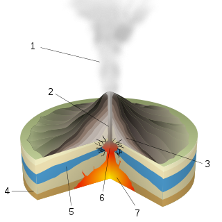
A caldera is a large cauldron-like hollow that forms shortly after the emptying of a magma chamber in a volcano eruption. When large volumes of magma are erupted over a short time, structural support for the rock above the magma chamber is gone. The ground surface then collapses into the emptied or partially emptied magma chamber, leaving a large depression at the surface. Although sometimes described as a crater, the feature is actually a type of sinkhole, as it is formed through subsidence and collapse rather than an explosion or impact. Compared to the thousands of volcanic eruptions that occur each century, the formation of a caldera is a rare event, occurring only a few times per century. Only seven caldera-forming collapses are known to have occurred between 1911 and 2016. More recently, a caldera collapse occurred at Kīlauea, Hawaii in 2018.

<span class="mw-page-title-main">Long Valley Caldera</span> Geologic depression near Mammoth Mountain, California, United States

Long Valley Caldera is a depression in eastern California that is adjacent to Mammoth Mountain. The valley is one of the Earth's largest calderas, measuring about 20 mi (32 km) long (east-west), 11 mi (18 km) wide (north-south), and up to 3,000 ft (910 m) deep.

<span class="mw-page-title-main">Lake Taupō</span> New Zealands largest lake

Lake Taupō is a large crater lake in New Zealand's North Island, located in the caldera of Taupō Volcano. The lake is the namesake of the town of Taupō, which sits on a bay in the lake's northeastern shore. With a surface area of 616 km2 (238 sq mi), it is the largest lake by surface area in New Zealand, and the second largest freshwater lake by surface area in geopolitical Oceania after Lake Murray in Papua New Guinea. Motutaiko Island lies in the southeastern area of the lake.

<span class="mw-page-title-main">Mono–Inyo Craters</span> Volcanic chain in eastern California, United States

The Mono–Inyo Craters are a volcanic chain of craters, domes and lava flows in Mono County, Eastern California. The chain stretches 25 miles (40 km) from the northwest shore of Mono Lake to the south of Mammoth Mountain. The Mono Lake Volcanic Field forms the northernmost part of the chain and consists of two volcanic islands in the lake and one cinder cone volcano on its northwest shore. Most of the Mono Craters, which make up the bulk of the northern part of the Mono–Inyo chain, are phreatic volcanoes that have since been either plugged or over-topped by rhyolite domes and lava flows. The Inyo volcanic chain form much of the southern part of the chain and consist of phreatic explosion pits, and rhyolitic lava flows and domes. The southernmost part of the chain consists of fumaroles and explosion pits on Mammoth Mountain and a set of cinder cones south of the mountain; the latter are called the Red Cones.

<span class="mw-page-title-main">Mount Katmai</span> Stratovolcano in Katmai National Park, Alaska, USA

Mount Katmai is a large active stratovolcano on the Alaska Peninsula in southern Alaska, located within Katmai National Park and Preserve. It is about 6.3 miles (10 km) in diameter with a central lake-filled caldera about two by three miles in size, formed during the Novarupta eruption of 1912. The caldera rim reaches a maximum elevation of 6,716 feet (2,047 m). In 1975 the surface of the crater lake was at an elevation of about 4,220 feet (1,286 m), and the estimated elevation of the caldera floor is about 3,400 ft (1,040 m). The mountain is located in Kodiak Island Borough, very close to its border with Lake and Peninsula Borough. The volcano has caused ten known fatalities due to gas exposure.

<span class="mw-page-title-main">Phreatic eruption</span> Volcanic eruption caused by an explosion of steam

A phreatic eruption, also called a phreatic explosion, ultravulcanian eruption or steam-blast eruption, occurs when magma heats ground water or surface water. The extreme temperature of the magma causes near-instantaneous evaporation of water to steam, resulting in an explosion of steam, water, ash, rock, and volcanic bombs. At Mount St. Helens in Washington state, hundreds of steam explosions preceded the 1980 Plinian eruption of the volcano. A less intense geothermal event may result in a mud volcano.

<span class="mw-page-title-main">Ambrym</span> Volcanic island in Vanuatu

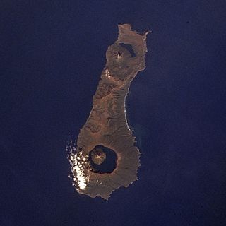
Ambrym is a volcanic island in Malampa Province in the archipelago of Vanuatu. Volcanic activity on the island includes lava lakes in two craters near the summit.

<span class="mw-page-title-main">Nemrut (volcano)</span>

Nemrut is a dormant volcano in Eastern Turkey, close to Lake Van. The volcano is named after King Nimrod who is said to have ruled this area in about 2100 BC.

<span class="mw-page-title-main">Cuicocha</span>

Cuicocha is a 3 km (2 mi) wide caldera and crater lake at the foot of Cotacachi Volcano in the Cordillera Occidental of the Ecuadorian Andes.

<span class="mw-page-title-main">Billy Mitchell (volcano)</span> Body of water

Billy Mitchell is a pyroclastic shield in the central part of the island of Bougainville, just north-east of the Bagana Volcano in Papua New Guinea. It is a small pyroclastic shield truncated by a 2 km wide caldera filled by a crater lake. It is named after Billy Mitchell, a 20th-century United States Army general who is regarded as the father of the United States Air Force.

<span class="mw-page-title-main">Tao-Rusyr Caldera</span> Stratovolcano with a caldera on the island of Onekotan

Tao-Rusyr Caldera is a stratovolcano located at the southern end of Onekotan Island, Kuril Islands, Russia. It has 7.5 km wide caldera formed during a catastrophic eruption less than 10,000 years ago. The waters of Kol'tsevoe Lake fill the caldera, along with a large symmetrical andesitic cone, Krenitsyn Peak, that rises as an island within the lake. This volcano was named after Captain Pyotr Krenitsyn of the Imperial Russian Navy.

<span class="mw-page-title-main">Kadovar</span> Volcanic island in Papua New Guinea

Kadovar is a volcanic island in Papua New Guinea northeast of the much larger island of New Guinea. The volcano erupted in January 2018 and the eruption is ongoing as of 2023, although the activity level is generally considered to be low. There were some heightened thermal phenomena in 1976.

<span class="mw-page-title-main">Timeline of volcanism on Earth</span>

This timeline of volcanism on Earth includes a list of major volcanic eruptions of approximately at least magnitude 6 on the Volcanic explosivity index (VEI) or equivalent sulfur dioxide emission during the Quaternary period. Other volcanic eruptions are also listed.

<span class="mw-page-title-main">Dakataua</span>

The Dakataua Caldera is located at the northern tip of the Willaumez Peninsula, New Britain, Papua New Guinea. The peninsula includes the 350 m high andesitic Mount Makalia stratovolcano. The last major collapse of Dakataua was during the Holocene around 800 CE. The most recent eruption on the caldera's rim was Mount Makalia in 1890, producing lava flows and cinder cones.

<span class="mw-page-title-main">Honolulu Volcanics</span> Volcanic field in Oʻahu, Hawaiʻi

The Honolulu Volcanics are a group of volcanoes which form a volcanic field on the island of Oʻahu, Hawaiʻi, more specifically in that island's southeastern sector and in the city of Honolulu from Pearl Harbor to the Mokapu Peninsula. It is part of the rejuvenated stage of Hawaiian volcanic activity, which occurred after the main stage of volcanic activity that on Oʻahu built the Koʻolau volcano. These volcanoes formed through dominantly explosive eruptions and gave rise to cinder cones, lava flows, tuff cones and volcanic islands. Among these are well known landmarks such as Diamond Head and Punchbowl Crater.

<span class="mw-page-title-main">Tolokiwa Island</span>

Tolokiwa Island, also known as Lottin Island, is an island in the Bismarck Sea. The island is volcanic in origin and part of the Bismarck Archipelago.

<span class="mw-page-title-main">Volcanic tsunami</span> Natural hazard

A volcanic tsunami, also called a volcanogenic tsunami, is a tsunami produced by volcanic phenomena. About 20–25% of all fatalities at volcanoes during the past 250 years have been caused by volcanic tsunamis. The most devastating volcanic tsunami in recorded history was that produced by the 1883 eruption of Krakatoa. The waves reached heights of 40 m (130 ft) and killed 36,000 people.

<span class="mw-page-title-main">Bam Island (Papua New Guinea)</span> Volcanic island in Papua New Guinea

Bam, also known as Biem, is a small volcanic island off the coast of Papua New Guinea, 40 km north northeast of the Sepik river mouth. It represents the southernmost island of the Schouten Islands. The northern coast of the island is inhabited by a village and coconut groves. Much of the island is forested, except along its south flank. As of 2018, the island has a population of approximately 3,000 people.

Hargy is a large volcanic caldera on the island of New Britain, Papua New Guinea. The caldera measures 12 km (7.5 mi) by 10 km (6.2 mi), and its floor is located at 150 m (490 ft) above sea level. It also hosts an inner-caldera with a steep west-facing wall. Lake Hargy, located within the caldera, drains through a narrow river that runs along the northern wall. The caldera-forming eruption occurred approximately 11,000 years ago. At the western part of the caldera rises Galloseulo, a post-caldera dacitic lava cone with a 700 m (2,300 ft)-wide crater, occupied by a pair of smaller craters. Galloseulo has produced many small eruptions in the past 7,000 years, with the most recent in 950 CE. In September 1990, minor fumarolic activity was observed in the western summit crater of Galloseulo.

References

  1. Specht, Jim; Ball, Eldon E.; Blong, R. J.; Egloff, B. J.; Hughes, Ian M.; McKee, C. O.; Pain, C. F. (1982-07-31). "Long Island, Papua New Guinea: Introduction". Records of the Australian Museum. 34 (6): 407–417. doi:10.3853/j.0067-1975.34.1982.288. ISSN   0067-1975.
  2. Specht, J.; et al. (1980). "Long Island, Papua New Guinea: Introduction" (PDF). Records of the Australian Museum. 34 (6): 407–417. doi:10.3853/j.0067-1975.34.1982.288 . Retrieved 2016-04-08.
  3. Hoffman, G. (Fall 2008). "Volcanic flow deposits on the flanks of Long Island, Papua New Guinea: lavas or pyroclastics?". AGU Fall Meeting Abstracts. Harvard. 2008: V11C–2067. Bibcode:2008AGUFM.V11C2067H.
  4. Blong, Russell J. (1982). Time of Darkness. Canberra: Australian National University Press.
  5. 1 2 3 4 5 6 7 8 9 10 Ball, Eldon E.; Hughes, Ian M. (1982-07-31). "Long Island, Papua New Guinea: people, resources and culture". Records of the Australian Museum. 34 (10): 463–525. doi:10.3853/j.0067-1975.34.1982.292. ISSN   0067-1975.
  6. 1 2 Egloff, B. J.; Specht, Jim (1982-07-31). "Long Island, Papua New Guinea: aspects of the prehistory". Records of the Australian Museum. 34 (8): 427–446. doi:10.3853/j.0067-1975.34.1982.290. ISSN   0067-1975.
  7. Coello, Francisco "Conflicto hispano-alemán" Boletín de Sociedad Geográfica de Madrid, t.XIX. 2º semestre 1885, Madrid, p.371.
  8. Kolonialbibliothek / Deutsche Kolonialzeitung : Organ der Deutschen Kolonialgesellschaft : Neue Folge 10 (1897). München. 1897.
  9. 1 2 3 4 Thornton, Ian W. B. (2003-02-03). "Colonization of an island volcano, Long Island, Papua New Guinea, and an emergent island, Motmot, in its caldera lake. I. General introduction". Journal of Biogeography. 28 (11–12): 1299–1310. doi:10.1046/j.1365-2699.2001.2811121299.x. ISSN   0305-0270.
  10. 1 2 New, Tim (2007), Thornton, Ian; New, Tim (eds.), "Lake Wisdom: a new island of fresh water", Island Colonization: The Origin and Development of Island Communities, Ecological Reviews, Cambridge: Cambridge University Press, pp. 137–141, ISBN   978-0-521-85484-9 , retrieved 2023-04-06
  11. 1 2 3 4 BALL, E.; GLUCKSMAN, J. (1978). "Limnological studies of Lake Wisdom, a large New Guinea caldera lake with a simple fauna". Freshwater Biology. 8 (5): 455–468. doi:10.1111/j.1365-2427.1978.tb01468.x. ISSN   0046-5070.