St Matthias Islands

Last updated
Satellite image of the St Matthias Islands St Matthias Islands (NASA).JPG
Satellite image of the St Matthias Islands

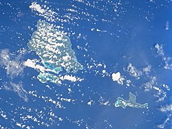
The St Matthias Islands (also known as the Mussau islands) are a small archipelago group of islands in the Bismarck Archipelago, in northern Papua New Guinea. They are within New Ireland Province. [1]

Geography

There are at least 10 islands. The largest and most northerly is Mussau.

To the southwest of Mussau are: Eloaua, Emananus, Boliu, Emussau, Ebanalu, Ekaleu, and a few smaller isles. To the east of Mussau are: Emirau, and further east is Tench Island.

The islands have been designated as an Endemic Bird Area by Birdlife International.

Related Research Articles

<span class="mw-page-title-main">Geography of Papua New Guinea</span> Geographical features of Papua New Guinea

The geography of Papua New Guinea describes the eastern half of the island of New Guinea, the islands of New Ireland, New Britain and Bougainville, and smaller nearby islands. Together these make up the nation of Papua New Guinea in tropical Oceania, located in the western edge of the Pacific Ocean.

<span class="mw-page-title-main">Melanesia</span> Subregion of Oceania

Melanesia is a subregion of Oceania in the southwestern Pacific Ocean. It extends from New Guinea in the west to the Fiji Islands in the east, and includes the Arafura Sea.

<span class="mw-page-title-main">New Britain</span> Island in Papua New Guinea

New Britain is the largest island in the Bismarck Archipelago, part of the Islands Region of Papua New Guinea. It is separated from New Guinea by a northwest corner of the Solomon Sea and from New Ireland by St. George's Channel. The main towns of New Britain are Rabaul/Kokopo and Kimbe. The island is roughly the size of Taiwan. When the island was part of German New Guinea, its name was Neupommern . In common with most of the Bismarcks it was largely formed by volcanic processes, and has active volcanoes including Ulawun, Langila, the Garbuna Group, the Sulu Range, and the volcanoes Tavurvur and Vulcan of the Rabaul caldera. A major eruption of Tavurvur in 1994 destroyed the East New Britain provincial capital of Rabaul. Most of the town still lies under metres of ash, and the capital has been moved to nearby Kokopo.

<span class="mw-page-title-main">Bismarck Archipelago</span> Archipelago in northeast Papua New Guinea

The Bismarck Archipelago is a group of islands off the northeastern coast of New Guinea in the western Pacific Ocean and is part of the Islands Region of Papua New Guinea. Its area is about 50,000 square km.

<span class="mw-page-title-main">New Ireland Province</span> Province of Papua New Guinea

New Ireland Province, formerly New Mecklenburg, and Nova Hibernia, is the northeasternmost province of Papua New Guinea.

<span class="mw-page-title-main">Oceanic languages</span> Subgroup of the Austronesian language family

The approximately 450 Oceanic languages are a branch of the Austronesian languages. The area occupied by speakers of these languages includes Polynesia, as well as much of Melanesia and Micronesia. Though covering a vast area, Oceanic languages are spoken by only two million people. The largest individual Oceanic languages are Eastern Fijian with over 600,000 speakers, and Samoan with an estimated 400,000 speakers. The Gilbertese (Kiribati), Tongan, Tahitian, Māori and Tolai languages each have over 100,000 speakers. The common ancestor which is reconstructed for this group of languages is called Proto-Oceanic.

<span class="mw-page-title-main">Emirau Island</span> Island in Papua New Guinea

Emirau Island, also called Emira, is an island in the Bismarck Archipelago located at 1°38.5′S149°58.5′E. Emira is part of what on many maps are charted as the St Matthias Islands, also known as the Mussau Islands, a small group to the northwest of the main island group of New Ireland. Early explorers named it Squally Island, a name found in some early records. It is part of New Ireland Province, Papua New Guinea. The local language is a dialect of the Mussau-Emira language.

The Mussau-Emira language is spoken on the islands of Mussau and Emirau in the St Matthias Islands in the Bismarck Archipelago.

<span class="mw-page-title-main">Rambutyo Island</span> Island in Papua New Guinea

Rambutyo Island is one of the Admiralty Islands in the Bismarck Archipelago. Politically, Rambutyo Island is part of Manus Province, Papua New Guinea. The population (unknown) is concentrated on the west coast. Villages include Mouklen and Lengkau.

<span class="mw-page-title-main">Green Islands (Papua New Guinea)</span> Island group in Papua New Guinea

The Green Islands is a small archipelago of islands in the Solomon Sea, within the Autonomous Region of Bougainville, in northeastern Papua New Guinea.

<span class="mw-page-title-main">Mussau fantail</span> Species of bird

The Mussau fantail or Matthias fantail, is a fantail which is endemic to Mussau Island in the St. Matthias Islands of Papua New Guinea.

<span class="mw-page-title-main">Mussau Island</span> Island in the New Ireland Province of Papua New Guinea

Mussau Island is the largest island of St Matthias Islands, Papua New Guinea, at 1°25′01″S149°37′59″E. It is part of the New Ireland Province of Papua New Guinea. The island is a noted biodiversity hotspot with pristine primeval rainforest covering most of Mussau's hilly landscape. The island has over 243 endemic plant species as well as at least 47 native butterfly species.

The Mussau monarch, also known as the white-breasted monarch, is a species of bird in the family Monarchidae. It is endemic to the Bismarck Archipelago of Papua New Guinea. Its natural habitats are subtropical or tropical moist lowland forests and rural gardens. It is threatened by habitat loss.

<span class="mw-page-title-main">Russet-tailed thrush</span> Species of bird

The russet-tailed thrush is a species of bird in the family Turdidae, closely related to the more widespread Bassian thrush. It is found in eastern Australia and Papua New Guinea.

<span class="mw-page-title-main">Admiralty flying fox</span> Species of bat

The Admiralty flying fox is a species of fruit bat in the family Pteropodidae, the megabats. It is found in Papua New Guinea and the Solomon Islands.

<span class="mw-page-title-main">New Guinea</span> Island in the Pacific Ocean

New Guinea is the world's second-largest island, with an area of 785,753 km2 (303,381 sq mi). Located in Melanesia in the southwestern Pacific Ocean, the island is separated from Australia by the 150-kilometre wide Torres Strait, though both landmasses lie on the same continental shelf, and were united during episodes of low sea level in the Pleistocene glaciations as the combined landmass of Sahul. Numerous smaller islands are located to the west and east. The island's name was given by Spanish explorer Yñigo Ortiz de Retez during his maritime expedition of 1545 due to the resemblance of the indigenous peoples of the island to those in the African region of Guinea.

<span class="mw-page-title-main">North Bismarck Plate</span> Small tectonic plate in the Bismarck Sea north of New Guinea

The North Bismarck Plate is a small tectonic plate located in the Bismarck Sea off the northeast coast of New Guinea. It is currently regarded as a relic or inactive plate by most. At one time it was called the Manus Plate, but this term was later used for a modelled microplate at the south east boundary of the North Bismarck Plate.

<span class="mw-page-title-main">Solomon Islands (archipelago)</span> Archipelago in the South Pacific spreading over two countries

The Solomon Islands (archipelago) is an island group in the western South Pacific Ocean, north-east of Australia. The archipelago is in the Melanesian subregion and bioregion of Oceania and forms the eastern boundary of the Solomon Sea. The many islands of the archipelago are distributed across the sovereign states of Papua New Guinea and Solomon Islands. The largest island in the archipelago is Bougainville Island, which is a part of the Autonomous Region of Bougainville along with Buka Island, the Nukumanu Islands, and a number of smaller nearby islands. Much of the remainder falls within the territory of Solomon Islands and include the atolls of Ontong Java, Sikaiana, the raised coral atolls of Bellona and Rennell, and the volcanic islands of Choiseul, Guadalcanal, Makira, Malaita, New Georgia, the Nggelas, Santa Isabel, and the Shortlands. The Santa Cruz Islands are not a part of the archipelago.

<span class="mw-page-title-main">West Melanesian Trench</span> Oceanic trench in the Bismarck Sea north of Papua New Guinea

The West Melanesian Trench is an oceanic trench in the Bismarck Sea north of Papua New Guinea delineating the plate tectonic boundary between the Caroline and North Bismarck plates.

<span class="mw-page-title-main">Mussau Island blue-tailed monitor</span> Species of lizard

The Mussau Island blue-tailed monitor or Mussau monitor is a species of monitor lizard endemic to Mussau Island in Papua New Guinea. It belongs to the Varanus doreanus species complex.

References

1°35′S149°49′E / 1.583°S 149.817°E / -1.583; 149.817